Model Madness: Hurricane Irma Edition
A Collaborative Post By Bill Murray & Scott Martin
We have so much data available to us that is so easy to get lost in watching the output from various runs and models. But it is helpful to review some of the scenarios that MIGHT happen and analyze their likelihood by using synoptic data. The ensembles help us to get an idea what the percentage chance a certain scenario has to occur in reality. Watching the trends is helpful, if not maddening.
The morning runs of the two global models (GFS and European) have shifted westward which would change impacts in many ways.
Don’t take any of these runs as gospel. Individual runs are just possibilities of what various scenarios might look like. The center of the hurricane could be anywhere in the cone of uncertainty on the official National Hurricane Center forecast track and the impacts would be based on that location.
GFS
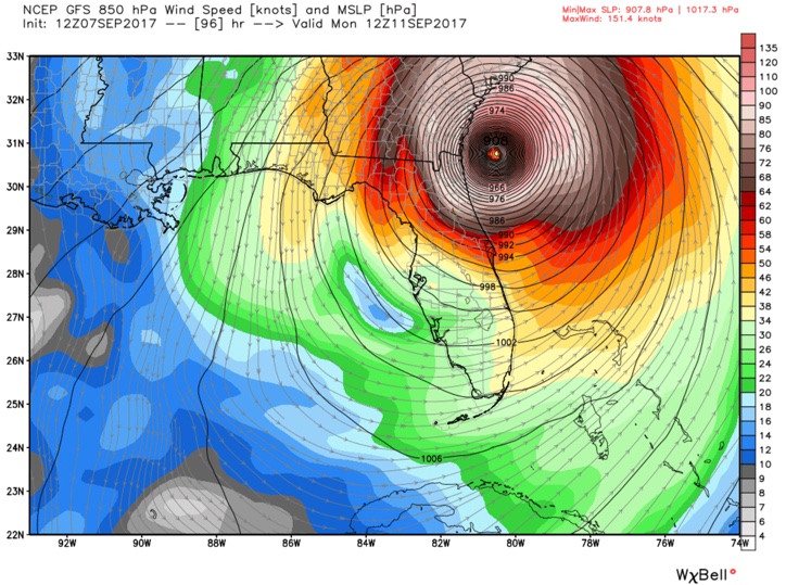
The noon run of the GFS is frankly more concerning for Miami and the East Coast of Florida. The GFS starts intensifying the storm rapidly late Friday night, dropping the central pressure to near 900 mb by early Saturday with winds around 145-150 mph. That would be a strong category four almost category five hurricane. The operational run starts turning it northward early Sunday morning just before it would have made landfall over Biscayne Bay and Miami.
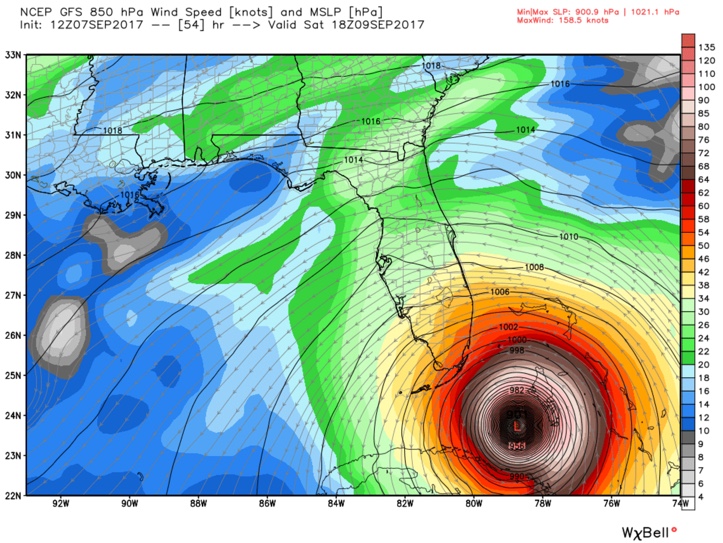
Irma curves north-northwestward, never making landfall in south Florida, passing just offshore along the entire East Coast of the state as a powerful category four hurricane. This would bring hurricane force gusts to every part of the coast of Florida from the Middle Keys to Amelia Island. The landfall would come late Monday morning west of Savannah, putting the historic city in grave danger. A large surge will impact much of the South Carolina coast.
The 12z (7 a.m. CDT) operational run of American global model had been a little more optimistic, keeping the system further offshore and weakening it more as it moved northward.
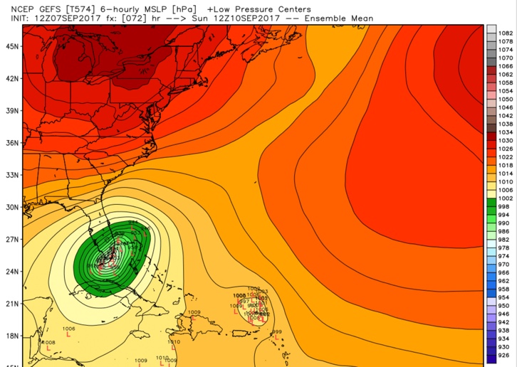
The ensembles from the GFS favor a direct strike on Miami/Fort Lauderdale (around 45%), with around 20% of the members hitting the Lower or Middle Keys. About 15% carry it closely up the East Coast of Florida with another 20% tracking further off the Florida Coast. About 50% of the members go up the Peninsula over land. About 20% head for Georgia and the last 30% moving toward eastern North Carolina.
EUROPEAN
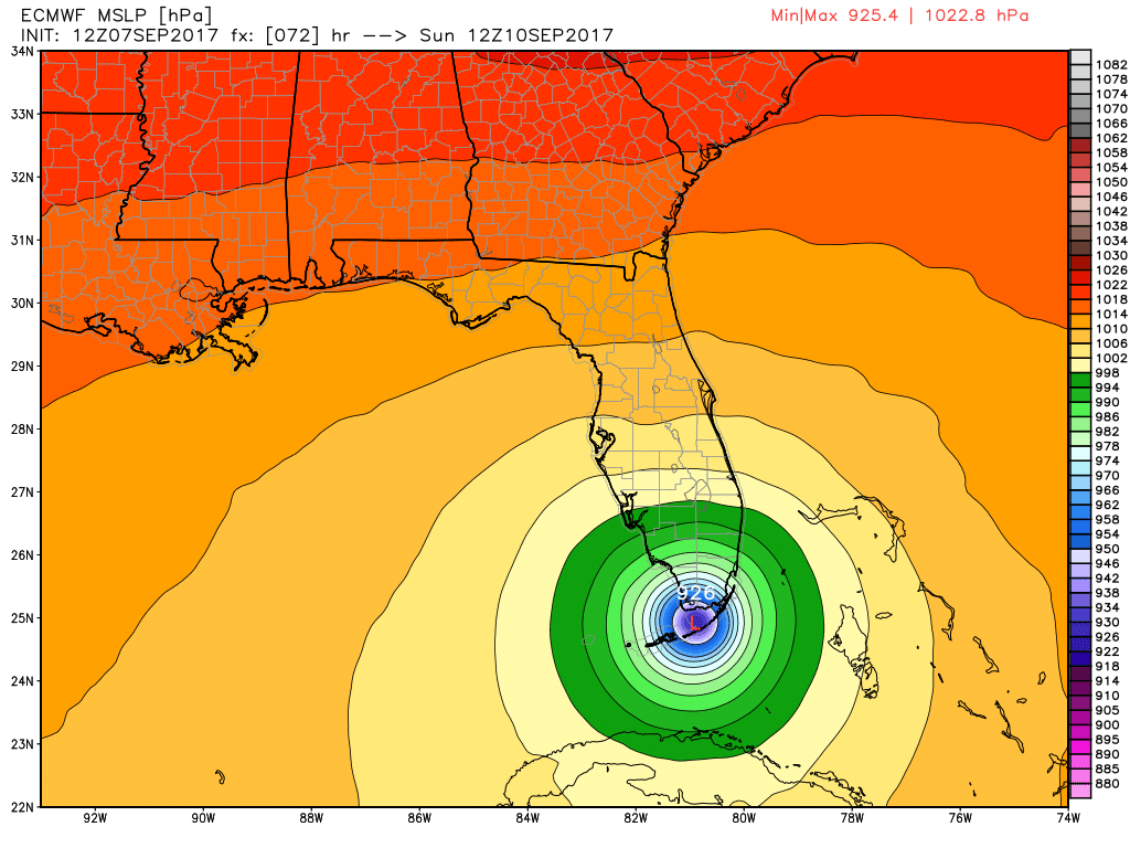
The latest run will have Irma moving a little farther west before the northward turn, but will still bring the eye on shore across the Keys and into the extreme southern part of the Florida Peninsula in the Everglades National Park as a strong category 5 storm. Winds are estimated to be around 170 MPH and minimum pressure will be close to 900mb. After landfall, the eye is modeled to move directly up the spine of the peninsula throughout the day and night on Sunday and into the lunch hour on Monday. At that time, wind speeds are still expected to be near 100 MPH. After that, the center will move up into Georgia and move close to the AL/GA state line and greatly weakening. This solution could bring some heavy rain to Central Alabama, and winds could be gusty to strong at times, over 50MPH over portions of the eastern half of the area on Monday evening and throughout the day on Tuesday.
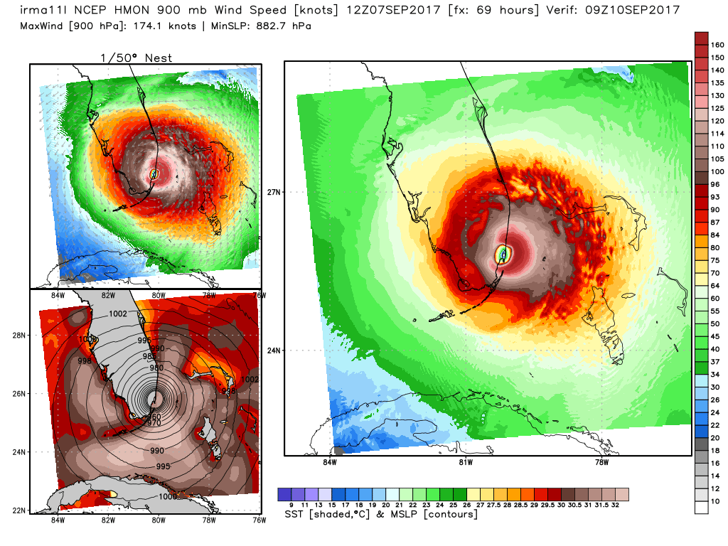
HMON
The latest run of the HMON model had Irma moving onto the southeast Florida coastline and the eye entering into Biscayne Bay and the Miami metropolitan area during the very early morning hours on Sunday (just after midnight). Strength at that time is projected to have a minimum central pressure of 890mb, which sounds really low but is completely possible, and wind speeds around 190 MPH. Actual projected landfall will happen at West Palm Beach just a few hours later. The center makes its way back offshore rather quickly and moves northward, making another landfall near Savannah on early Monday morning as a very strong and destructive category 4 hurricane with winds around 150 MPH.
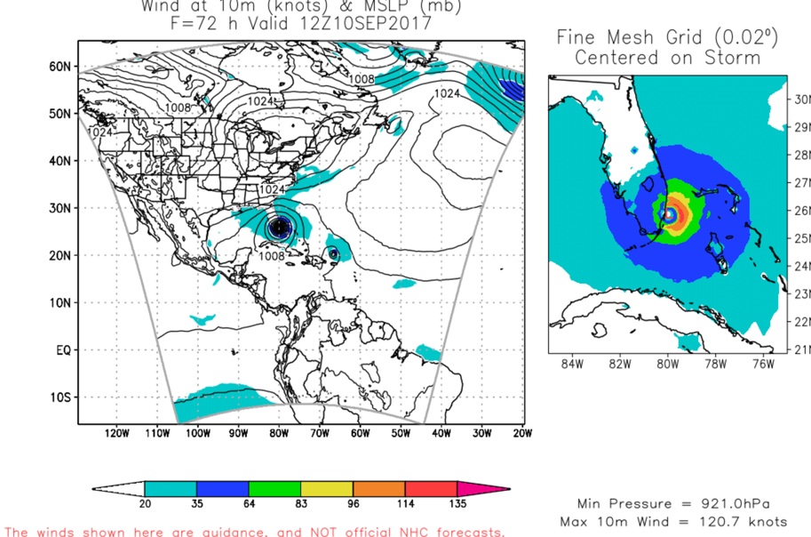
HWRF
The HWRF makes a more direct hit on West Palm Beach early Sunday morning (921 mb) and then makes a secondary landfall west of Savannah Monday noon.
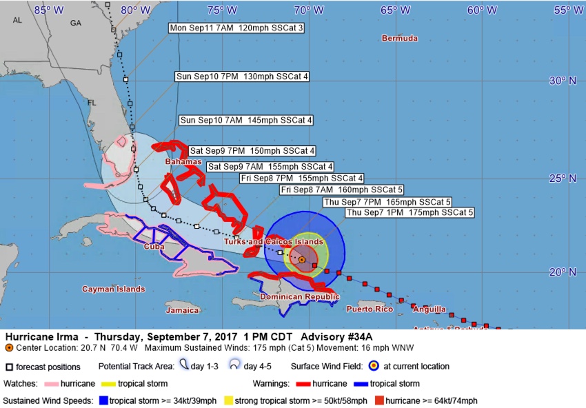
BEST TRACK
The NHC uses all of this data with their huge amount of expertise to produce the best forecast. Here is the track with the notorious cone of uncertainty, that takes into account the average forecast errors to depict the area where the center may end up. The cone gets wider as you got through time because average forecast errors get larger the further out you go in time from the issuance of the forecast.
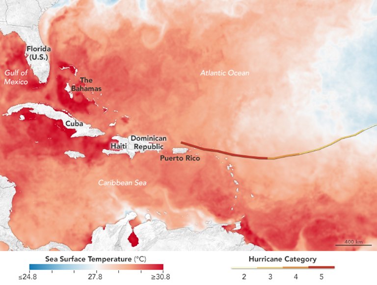
SEA SURFACE TEMPERATURES
The latest sea surface temperature graphic shows that warmer waters lie ahead in the path of the eye of Irma. When Irma makes its way in between Cuba and The Bahamas, sea surface temperatures are in the 86-88 degree range, well more than warm enough to help sustain and possibly strengthen a hurricane.
About the Author (Author Profile)
Scott Martin is an operational meteorologist, professional graphic artist, musician, husband, and father. Not only is Scott a member of the National Weather Association, but he is also the Central Alabama Chapter of the NWA president. Scott is also the co-founder of Racecast Weather, which provides forecasts for many racing series across the USA. He also supplies forecasts for the BassMaster Elite Series events including the BassMaster Classic.Subscribe
If you enjoyed this article, subscribe to receive more just like it.


Comments (35)
Trackback URL | Comments RSS Feed
Sites That Link to this Post