Monday Evening Update On Irma
New model continues to roll in this evening…
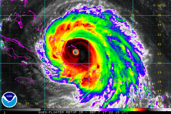
*Irma remains a dangerous, category five hurricane with sustained winds of 175 mph. The eye of Irma should continue to move between Hispaniola and the Turks and Caicos Islands this evening. The core of the hurricane will then move between the north coast of Cuba and the Bahamas during the next day or two.
*NHC in their late afternoon forecast package adjusted the forecast track of Irma slightly to the left, suggesting the circulation center will go northward, right up the spine of Florida. This has big implications for the Florida Atlantic coast; there is high potential for major storm surge and wind damage for the major cities there Sunday and Sunday night, including Miami, Fort Lauderdale, West Palm Beach, Daytona Beach, and Jacksonville.
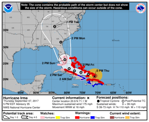
*Orlando could see hurricane force winds during the day Sunday with potential for significant tree and power line damage, and some structural damage.
*The west coast cities like Tampa, St. Petersburg, Sarasota, Fort Myers, and Naples will also see lots of wind and rain with potential for downed trees and power lines. Storm surge damage is most likely from Naples south. But, impact will not be as high as what we expect on the Atlantic coast side of the peninsula.
*If you are under an evacuation order, don’t hesitate to leave. This is a large hurricane with potential for serious damage and storm surge flooding.
*Cities on the Central Gulf Coast like Gulf Shores, Pensacola, Navarre Beach, and Destin won’t have a big direct impact, although it will be windy at times Sunday night and Monday. No rain is expected there with a dry, offshore flow. The rest of next week looks rain-free on the coast as well.
*Panama City Beach will also be on the “good” west side of the circulation, but with the slight adjustment they could see wind gusts Sunday night and Monday in the 25-35 mph range with a few periods of rain. The rest of the week will feature delightful weather with sunny days and fair nights. If I had vacation plans, I would go there with no hesitation.
*Alabama’s weather will be beautiful through the weekend, but we will bring in a chance of rain Monday night and Tuesday as models are now suggesting the remnant circulation will drift westward as it gains latitude over Georgia. It will be windy as well across our state, but not enough wind to produce any significant damage. We will introduce that chance of rain into the forecast.
More later tonight…
Category: Alabama's Weather, ALL POSTS, Tropical
About the Author (Author Profile)
James Spann is one of the most recognized and trusted television meteorologists in the industry. He holds the AMS CCM designation and television seals from the AMS and NWA. He is a past winner of the Broadcast Meteorologist of the Year from both professional organizations.Subscribe
If you enjoyed this article, subscribe to receive more just like it.


