Hunker Down in the Keys! Irma Continues to Strengthen
Hurricane Irma will be one of the worst hurricanes ever in the Florida Keys and perhaps the worst ever to strike Key West.
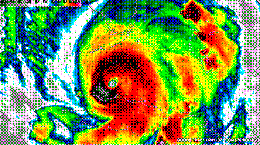
Here are some thoughts on the Hurricane Irma situation just after 4 a.m.:
…Irma’s eyewall is only about 10 miles south of Boca Chica Key. It will reach the Keys as early as 5:15 a.m.
…The center of the eye is now 35 miles southeast of Key West.
…The eye is 11 miles in diameter according to radar.
…The storm’s movement is NNW at 10 mph. A little bit of a turn to the right seems perceptible in the recon fixes.
…It looks like the eye will pass over Key West or over the keys just to the east starting around 8-8:30 a.m. CDT. The calm could last as much as an hour.
…The Air Force plane just flew around in the center. The pressure appears it will come back at 926 mb. I saw a max flight level wind of 135 mph and an SFMR of 120 mph.
…The storm looks more organized on satellite and radar. It is strengthening steadily. Convection near the center has increased on GOES-16 satellite infrared data.
…Max winds according to the Hurricane Center are still 130 mph, but may reach 140 mph before landfall in the Keys. Gusts will exceed 155 mph.
…Anyone left in the Florida Keys needs to be hunkered down now. The worst is yet to come. Move to an interior room away from windows. Gather blankets, pillows, and mattresses to cover yourself. Put on helmets.
About the Author (Author Profile)
Bill Murray is the President of The Weather Factory. He is the site's official weather historian and a weekend forecaster. He also anchors the site's severe weather coverage. Bill Murray is the proud holder of National Weather Association Digital Seal #0001 @wxhistorianSubscribe
If you enjoyed this article, subscribe to receive more just like it.


