Tropical Storm Warnings East Alabama
The weather situation for Central Alabama is quite fluid at this writing, so be sure to check back here often for updates on the latest weather conditions and forecasts.
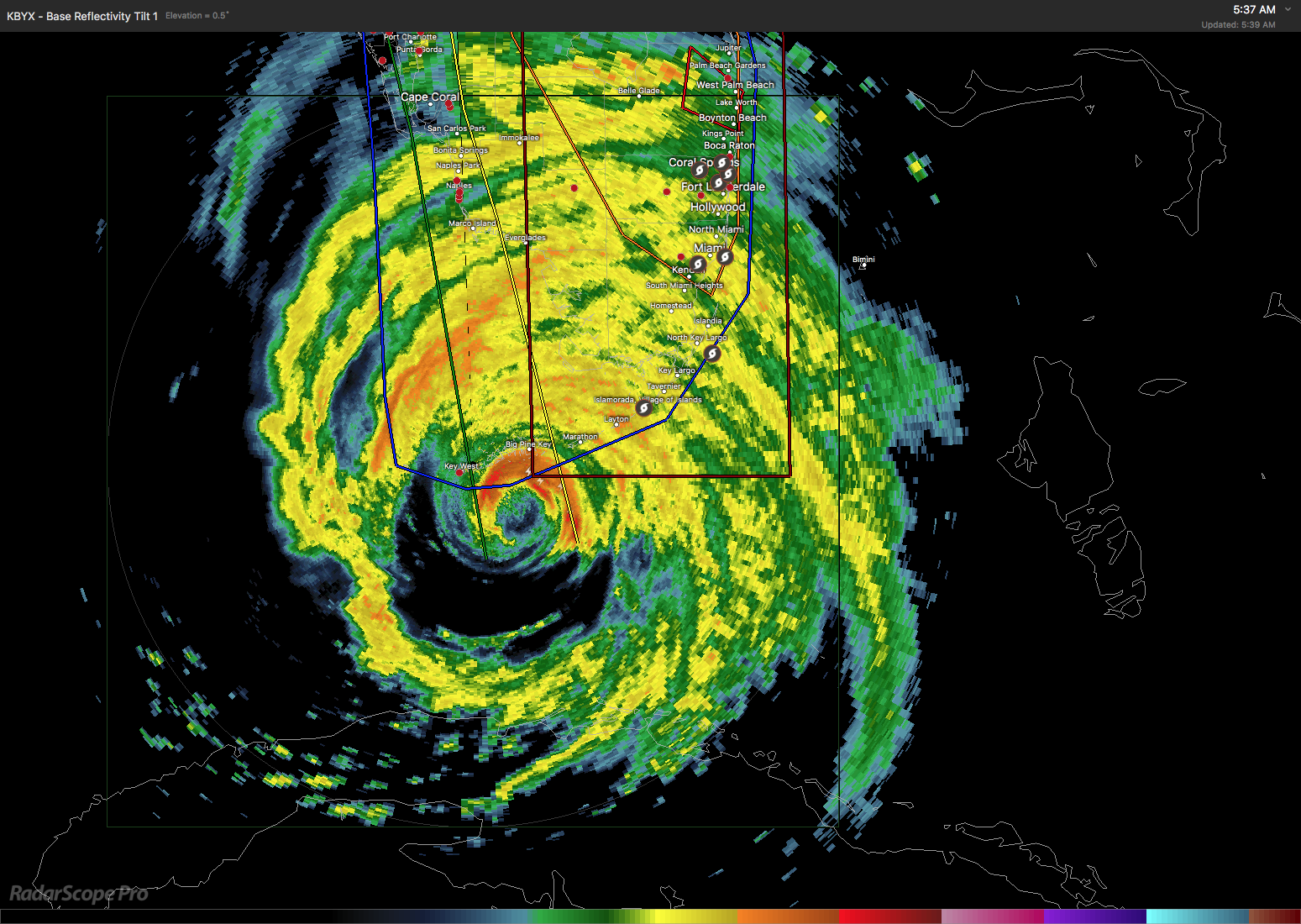
The morning satellite image showed clear skies across all but the southeast quadrant of Alabama and the cloud shield from Irma was quite prevalent. Morning temperatures in Central Alabama were in the lower 60s and the wind across the Southeast US was obviously being impacted by Irma. Clouds will be increasing across Alabama today as Irma progresses at a painfully slow rate across the southern end of the Florida Keys later this morning. The pressure gradient between the surface high over the eastern Great Lakes and the low pressure of Irma will tighten somewhat today with northeast wind at 10 top 15 mph today increasing and becoming gustier on Monday and into Tuesday.
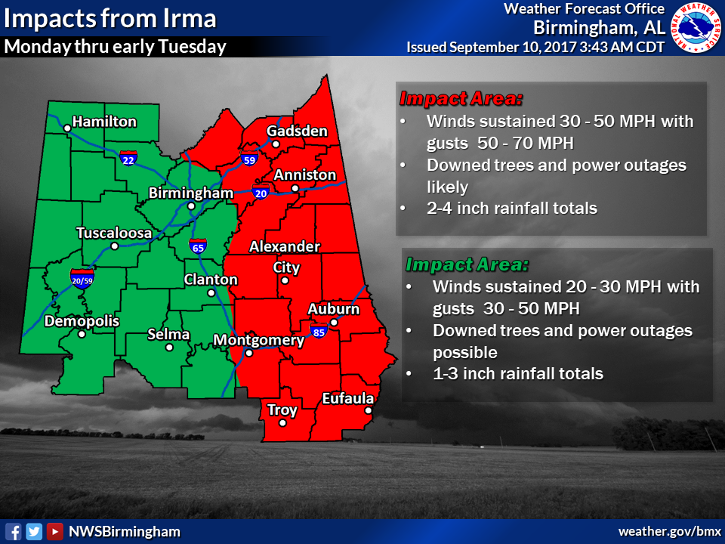
The exact weather you see will depend heavily on the exact track that Irma takes. There are still model differences though the various models are coming much closer together. This is the situation where a few miles one direction or another could make some substantial differences. Based on the NHC track, the NWS in Birmingham has put a number of counties along the eastern side of Alabama under a tropical storm warning while the northeast quadrant of the state was under a tropical storm watch. This includes nearly all of the area east of Interstate 65, but currently does not include Jefferson or Shelby counties. The warning means that tropical storm force wind, wind greater than 39 mph, is possible in the warned area in the next 36 hours. The warning is in effect now and through Monday.
Irma is forecast to move across the Tallahassee area around 2 pm on Monday as a hurricane but weaken to a tropical storm by early Tuesday morning. Weaken is a relative term, because Irma will still be strong enough to down numerous trees and power lines and generally create very unpleasant weather. Rainfall with the approach and passage of Irma will be in the 1 to 5 inch range with 1 to 3 inches in the western part of Alabama and 3 to 5 inches along the eastern portion of the state. Flash flooding should be held to localized spots. Tornadoes are not expected to be a threat with the main tornado threat further east of the track of Irma.
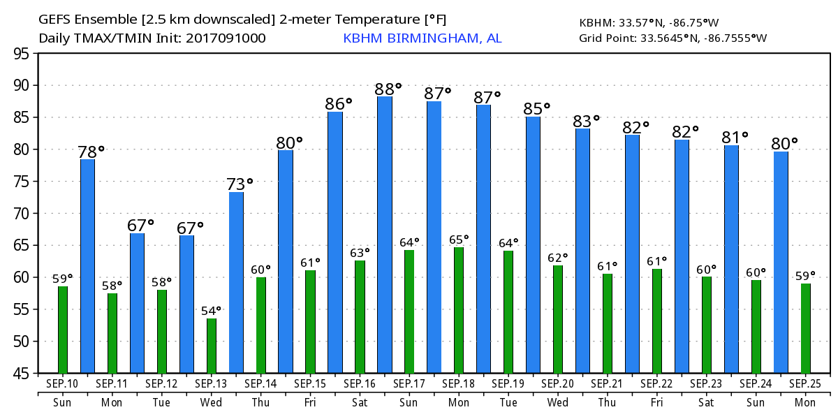
Irma is forecast to become a depression on Wednesday as it moves slowly across West Tennessee and western Kentucky. The upper air reflection of Irma remains strong through the middle of the week, so while the worst of the weather should be ending Tuesday, we’ll continue to see showers and thunderstorms on Wednesday and Thursday. Temperatures Monday and Tuesday will be held down substantially and some places may not reach 70 degrees. We should warm back into the lower 80s for the latter part of the week.
The upper air reflection of Irma will slowly pull away from the Ohio River Valley Wednesday into Thursday. By Friday the upper air reflection of Irma will be over the Mid-Atlantic states as we dry out. Upper air ridging comes into play for Friday and into next weekend. As it does we should see the afternoon highs climb into the middle 80s.
And I don’t want to forget Jose. Jose appears determined to challenge the record for the longest running tropical system in the Atlantic. Jose is forecast to make aloof in the Atlantic between Bermuda and the Bahamas in the Tuesday to Friday time frame. Jose is still visible on the upper air charts out into voodoo country as it meanders offshore from the Mid-Atlantic states and New England from September 20th to 25th.
Looking at the upper air pattern in voodoo country, the GFS is very bullish on bringing an upper level ridge into the eastern US for much of week 2. A very deep and strong upper trough will migrate across the western states and into Canada north of the Great Lakes between the 20th and 25th. But by the time we reach the 25th, another strong trough was making it ashore in the Northwest US. So the big message for this period is that the overall pattern will remain active while the Southeast US remains mainly within an upper ridge.
Be sure to keep up to date with the detailed forecasts from Fort Morgan over to Panama City Beach with the AlabamaWx Weather Blog. Click here to see the AlabamaWx Beach Forecast Center page. The Beach Forecast is partially underwritten by the support of Brett/Robinson Vacation Rentals in Gulf Shores and Orange Beach. Click here to see Brett/Robinson’s Hot Deals now!
The overall weather situation for Central Alabama will have some serious weather for the next three days, so be sure to stay up on the latest weather forecasts and warnings by checking back here often. James Spann will have the next Weather Xtreme video here on Monday morning. Stay safe and Godspeed.
-Brian-
Category: Alabama's Weather, ALL POSTS
About the Author (Author Profile)
Brian Peters is one of the television meteorologists at ABC3340 in Birmingham and a retired NWS Warning Coordination Meteorologist. He handles the weekend Weather Xtreme Videos and forecast discussion and is the Webmaster for the popular WeatherBrains podcast.Subscribe
If you enjoyed this article, subscribe to receive more just like it.


