Eyewall Impacting Lower Keys, Key West: Hurricane Force Gust at NWS Office
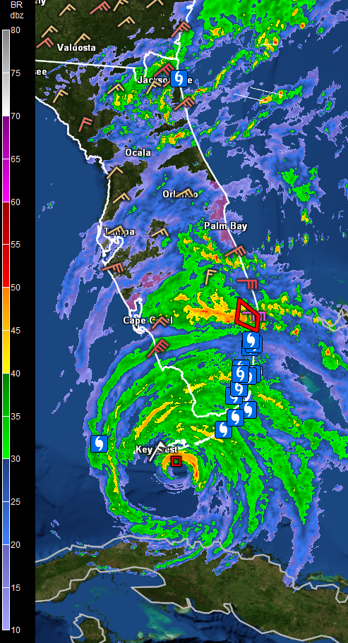
A wind gust to 89 mph was just measured at the National Weather Service Office in Key West. Frequent gusts to around 80 mph are being experienced at the NWS Office. Winds have recently gusted to 81 mph at the Key West International Airpor.
An extreme wind warning is in effect for the Lower Keys for tornado like damage from the eyewall.
The barometer there is down to 28.33 inches or 959 millibars.
The center of the eye is now 19 miles southeast of Key West. It is moving north northwest at 8 mph.
A tornado warning is in effect for the West Palm Beach area. Tornado watches cover the southeastern half of the Florida Peninsula.
Tides are currently running 2.65 feet above normal at Key West.
The Air Force plane is en route to the hurricane to monitor it.
About the Author (Author Profile)
Bill Murray is the President of The Weather Factory. He is the site's official weather historian and a weekend forecaster. He also anchors the site's severe weather coverage. Bill Murray is the proud holder of National Weather Association Digital Seal #0001 @wxhistorianSubscribe
If you enjoyed this article, subscribe to receive more just like it.


