Sunday Morning Notes On Irma
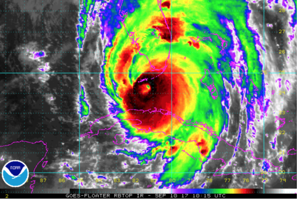
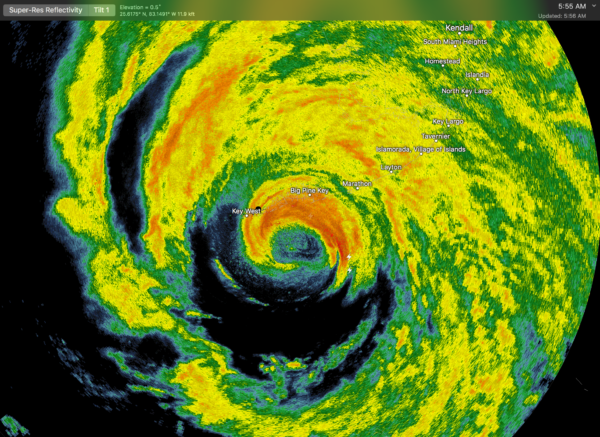
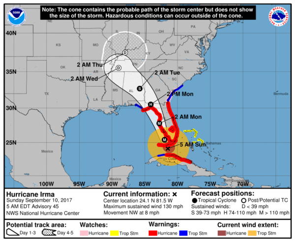
Extremely dangerous Hurricane Irma has made the “north turn”, and is moving over the Florida Keys this morning. On the forecast track, the eye of Irma should move near or over the southwestern coast of the Florida Peninsula later today through tonight.
Maximum sustained winds are near 130 mph with higher gusts. Irma is a category 4 hurricane on the Saffir-Simpson Hurricane Wind Scale. While weakening is forecast, Irma is expected to remain a powerful hurricane as it moves through the Florida Keys and and near the west coast of Florida.
Hurricane-force winds extend outward up to 80 miles from the center and tropical-storm-force winds extend outward up to 220 miles. The National Ocean Service station at Vaca Key Florida recently reported sustained winds of 48 mph and a gust of 78 mph. A private anemometer at Alligator Reef Light, Florida recently reported a wind gust of 88 mph. The latest minimum central pressure reported by an Air Force
Reserve Hurricane Hunter aircraft is 928 mb (27.41 inches).
IMPACT STATEMENTS
FLORIDA PENINSULA: Now, the greatest storm surge and wind damage will come later today and tonight over the Florida West Coast (Naples to Fort Myers to Sarasota to Tampa/St. Petersburg). Here is part of the statement from NWS Tampa…
– CURRENT THREAT TO LIFE AND PROPERTY: Extreme
– The wind threat has remained nearly steady from the
previous assessment.
– Emergency plans should include a reasonable threat for
major hurricane force wind greater than 110 mph of
equivalent Category 3 intensity or higher.
– To be safe, aggressively prepare for the potential of
devastating to catastrophic wind impacts. Remaining efforts
to secure properties should now be brought to completion.
– Extremely dangerous and life-threatening wind is possible.
Failure to adequately shelter may result in serious injury,
loss of life, or immense human suffering. Move to safe
shelter before the wind becomes hazardous.
– POTENTIAL IMPACTS: Devastating to Catastrophic
– Structural damage to sturdy buildings, some with complete
roof and wall failures. Complete destruction of mobile
homes. Damage greatly accentuated by large airborne
projectiles. Locations may be uninhabitable for weeks or
months.
– Numerous large trees snapped or uprooted along with fences
and roadway signs blown over.
– Many roads impassable from large debris, and more within
urban or heavily wooded places. Many bridges, causeways,
and access routes impassable.
– Widespread power and communications outages.
It is important to stress that hurricane force winds will be possible over ALL of the Florida Peninsula (not the Panhandle) later today and tonight. In addition to wind and storm surge damage, a few tornadoes will be possible.
While the impact over the Atlantic coast won’t be as severe, storm surge/wind damage is likely. Orlando will experience hurricane force winds tonight
This is a very serious, life threatening storm. Evacuation orders MUST be followed. It is a matter of life and death for many.
Get specific impact statements from these Florida NWS offices…
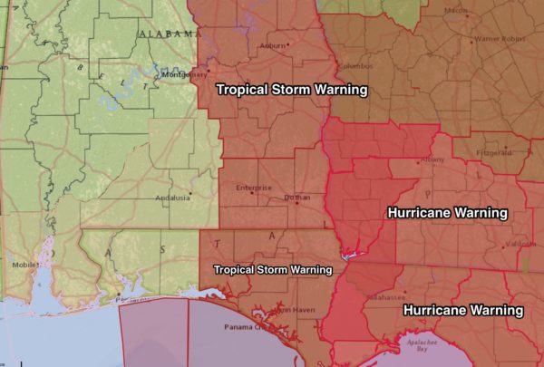
FLORIDA PANHANDLE: A hurricane warning is in effect from Indian Pass eastward; this is where winds could reach hurricane force. A tropical storm warning is in effect from Indian Pass to the Okaloosa/Walton County line.
Rain will be rather light for Pensacola, Navarre Beach, and Destin. It will be windy, of course, with a gusty north wind of 20-35 mph tonight and tomorrow. This is a dry, offshore flow.
At Panama City, they will get into the outer rain shield of tomorrow Monday with north winds of 40-50 mph. They will remain on the “good” west side of the circulation, however, meaning an offshore flow and no storm surge issues. But, the sustained wind could knock down a few trees and bring scattered power outages; there should be little if any structural damage. They are in the tropical storm warning.
Winds will be higher east of Panama City… Port St. Joe, Apalachicola, Cape San Blas will have winds of 60-75 mph Monday. Again, winds here will be out of the north and there will be no storm surge issues with an offshore flow. But, tree and power line damage here is very possible, if not likely. They are under a hurricane warning.
ALABAMA GULF COAST: Little or rain for Dauphin Island, Gulf Shores, or Orange Beach. Tomorrow will be windy with a north wind of 15-30 mph. Again, a dry, offshore flow.
The weather for the rest of the week (after tomorrow) on the Central Gulf Coast will be delightful with ample sunshine each day.
ALABAMA/GEORGIA: Tropical storm warnings have been issued for roughly the eastern half of Alabama, and much of Georgia.
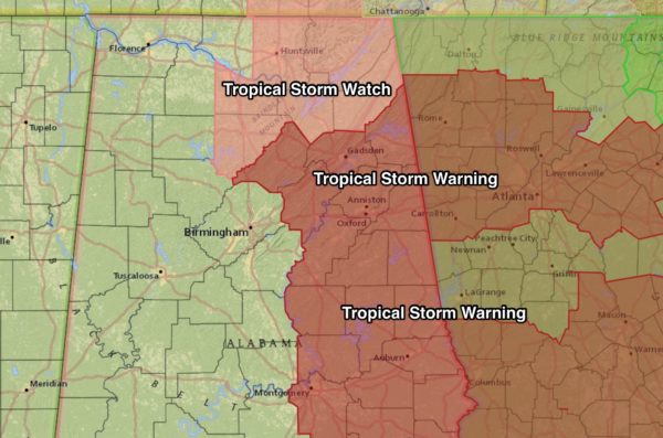
Tropical storm force winds begin at 39 mph, and they are possible across the eastern counties of Alabama and much of Georgia tomorrow afternoon, tomorrow night, and into Tuesday. Some of the cities in the tropical storm warning include Gadsden, Anniston, Sylacauga, Alexander City, Auburn, Montgomery, Troy, Eufaula, Ozark, and Dothan.
The tropical storm warning does not include Birmingham or Tuscaloosa.
A tropical storm watch has been issued for parts of Northeast Alabama, including places like Huntsville, Cullman, and Fort Payne.
Winds in the tropical storm warning are will be in the 30-50 mph range, with potential for gusts to 55/70 mph, especially across high terrain. Here is additional information from the impact statement issued by the NWS Birmingham…. this for those in the tropical storm warning over the eastern part of Alabama…
– CURRENT THREAT TO LIFE AND PROPERTY: Elevated
– The wind threat has remained nearly steady from the
previous assessment.
– Emergency plans should include a reasonable threat for
tropical storm force wind of 39 to 57 mph.
– To be safe, prepare for the potential of limited wind
impacts. Remaining efforts to secure properties should now
be brought to completion.
– Hazardous wind is possible. Failure to adequately shelter
may result in serious injury. Move to safe shelter before
the wind becomes hazardous.
– POTENTIAL IMPACTS: Limited
– Damage to porches, awnings, carports, sheds, and unanchored
mobile homes. Unsecured lightweight objects blown about.
– Many large tree limbs broken off. A few trees snapped or
uprooted, but with greater numbers in places where trees
are shallow rooted. Some fences and roadway signs blown
over.
– A few roads impassable from debris, particularly within
urban or heavily wooded places. Hazardous driving
conditions on bridges and other elevated roadways.
– Scattered power and communications outages.
Again, the main window for the higher winds will come late tomorrow afternoon, tomorrow night, and into Tuesday morning.
Rain amounts of 2-4 inches are likely, with heavier totals, possibly approaching 5 inches, near the Georgia border. Some flooding issues could develop over the eastern third of the state by Tuesday.
On the positive side, there is no tornado threat in Alabama as we remain on the west side of the storm circulation.
Keep an eye on the blog for updates throughout the day…
Category: Alabama's Weather, ALL POSTS, Tropical
About the Author (Author Profile)
James Spann is one of the most recognized and trusted television meteorologists in the industry. He holds the AMS CCM designation and television seals from the AMS and NWA. He is a past winner of the Broadcast Meteorologist of the Year from both professional organizations.Subscribe
If you enjoyed this article, subscribe to receive more just like it.


