Impact Of Irma On Alabama
Some notes on the Alabama impact… Sunday midday…
A tropical storm warning is in effect for much of East and Southeast Alabama tomorrow through Tuesday. A tropical storm watch is in effect for Northeast Alabama.
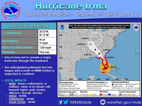
TIMING: Higher winds across Alabama will come from 12:00 p.m. tomorrow through 6:00 p.m. Tuesday as Irma, which should be a tropical depression by then, slides across Northeast Alabama.
THREATS: Gradient wind will be biggest issue. There is no risk of a tornado (SPC defines the tornado threat well to the east, near the coast of Georgia and South Carolina).
Winds over East and Southeast Alabama, in the tropical storm warning, will be in the 30-50 mph range, with higher gusts. Winds on ridges could gust to 60/70 mph in spots. This could take down some trees, and bring power outages.
For the western half of the state, winds will be in the 20-30 mph range with higher gusts. Scattered tree and power line damage is possible.
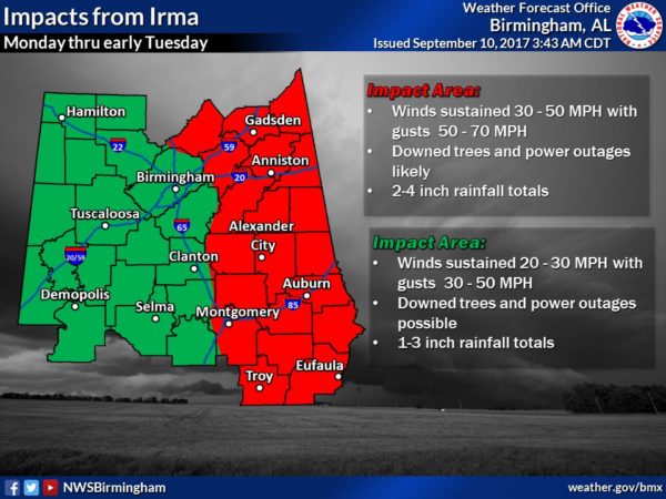
In the tropical storm watch area, over Northeast Alabama, winds will be in the 25-35 mph range with higher gusts late tomorrow, tomorrow night and Tuesday.
ALABAMA GULF COAST: Hardly any rain for the Alabama coast, just a gusty north wind. No real impact there.
Here is a midday Facebook live update on the storm.
SCHOOL CLOSINGS: See the ABC 33/40 closing page here.
We will have frequent updates on the blog through the event!
Category: Alabama's Weather, ALL POSTS
About the Author (Author Profile)
James Spann is one of the most recognized and trusted television meteorologists in the industry. He holds the AMS CCM designation and television seals from the AMS and NWA. He is a past winner of the Broadcast Meteorologist of the Year from both professional organizations.Subscribe
If you enjoyed this article, subscribe to receive more just like it.


