

Quite Warm Out There At Midday, But A Few Showers Are Out There
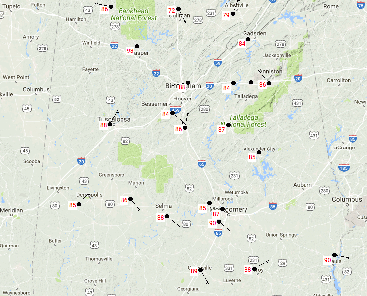
RADAR CHECK AT 1:10 PM

Currently across Central Alabama we have a mix of sun and clouds for most with dry conditions, but a few folks have some rain to deal with. There is decent shower activity located in parts of Winston, Cullman, Blount, and Etowah counties that are putting down some moderate to heavy rainfall. The good news is that none of these are particularly strong, just some good rain. There are a few isolated showers over in western parts of the area as well. All of these are slowly drifting to the south.
TEMPERATURES AT 1:10 PM
Temperatures are currently ranging in between rain cooled air in the lower 70s to hot and steamy 90 degrees to the south. Highs will be able to reach the upper 80s to the lower 90s today, unless shower activity occurs at your location before the hottest part of the day and brings a cool down.
REST OF TODAY
We’ll continue to have a chance of scattered afternoon and early evening showers and thunderstorms throughout the area, otherwise skies will be partly clouds. Afternoon highs will be in the upper 80s to the lower 90s throughout the area. There could be a lingering shower or two through the evening hours, but all rain should diminish by bedtime. We’ll have mostly clear skies throughout the overnight hours with some patchy fog possible. Overnight lows will be in the mid-60s to the lower 70s.
MONDAY’S WEATHER
Even though we will still have pretty moist air over Central Alabama, we will lack the forcing for any shower and thunderstorm development during the day. We’ll have a mix of sun and clouds, and temperatures will be on the very warm to hot side. Afternoon highs will be in the upper 80s to the lower 90s throughout the area. Skies will become mostly clear during the evening hours and stay that way throughout the overnight. Lows will dip down into the mid-60s to the lower 70s.
STILL VERY ACTIVE IN THE TROPICS
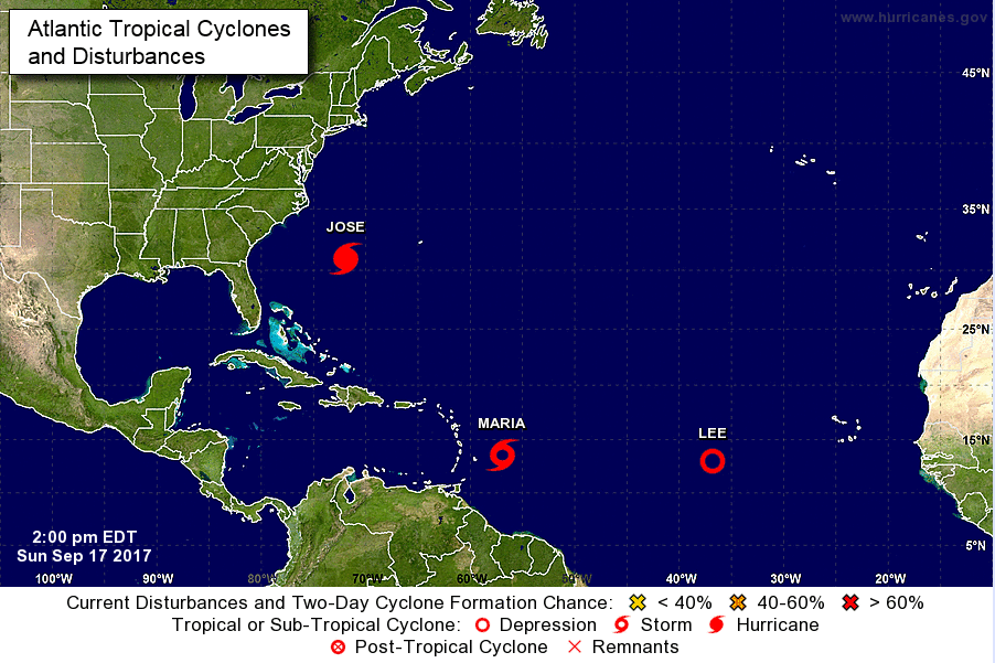
Hurricane Jose is on a northward path well off of the Atlantic Coast and is expected to weaken by Wednesday into a tropical storm and turn eastward. It will have a close approach to Rhode Island and Maryland, but the center is forecast not to make landfall. Dangerous rip currents and rough seas will continue along the coast.
The next storm we need to keep our eyes on is Tropical Storm Maria. She is expected to become a major hurricane within the next 3 or 4 days and its projected path for the next 5 days is pretty similar to where Irma travelled. Maria will cross over the Leeward Islands starting tomorrow evening and then Puerto Rico on Wednesday night into Thursday morning. Then the center will move very close to the northern shores of the Dominican Republic. Long range models continue to have Maria curving to the northeast before reaching the Bahamas within the next 168 hours. After that, we’ll have to see. The GFS is keeping her offshore.
Finally, we get to now Tropical Depression Lee, which may not be with us for much longer. Projected path has Lee moving to the northeast and becoming post-tropical by Tuesday morning. No threat to any land at all.
OUR TROPICAL WEATHER CATEGORY HAS THE LATEST ON ALL ACTIVE STORMS
Stay up-to-date with the latest updates on all of the tropical systems out in the Atlantic Ocean, Caribbean Sea, or in the Gulf of Mexico with the latest posts in our Tropical Weather section. Click here to see the latest.
GOT BEACH PLANS?
Be sure to keep up to date with the detailed forecasts from Fort Morgan over to Panama City Beach with the AlabamaWx Weather Blog. Click here to see the AlabamaWx Beach Forecast Center page.
The Beach Forecast is partially underwritten by the support of Brett/Robinson Vacation Rentals in Gulf Shores and Orange Beach. Click here to see Brett/Robinson’s Hot Deals now!
ADVERTISE WITH ALABAMAWX
Now is the time to set your marketing campaign on AlabamaWX. The site has enjoyed a 71% jump in page views this year! The website has already enjoyed over 12 MILLION page views this year. We can customize a creative, flexible and affordable package that will suit your organization’s needs. Contact Bill Murray at (205) 687-0782.
E-FORECAST
Get the AlabamaWx seven-day forecast delivered directly to your inbox by email twice daily. It is the most detailed weather forecast available in Central Alabama. Click here to subscribe. It’s free!
ON THIS DAY IN WEATHER HISTORY
1989 – Hurricane Hugo hit the Virgin Islands, producing wind gusts to 97 mph at Saint Croix. Hurricane Hugo passed directly over the island of Saint Croix causing complete devastation and essentially cutting off the island from communications. A storm surge of five to seven feet occurred at Saint Croix. The only rain gauge left operating, at Caneel Bay, indicated 9.40 inches in 24 hours. Hurricane Hugo claimed the lives of three persons at Saint Croix, and caused more than 500 million dollars damage. A ship, Nightcap, in the harbor of Culebra, measured wind gusts as high as 170 mph. A cold front brought high winds to the Great Basin and the Rocky Mountain Region, and thunderstorms along the cold front produced wind gusts to 66 mph at Yellowstone Park WY.
WEATHERBRAINS
Check out the show at www.WeatherBrains.com. You can also subscribe on iTunes. You can watch the show live at live.bigbrainsmedia.com on Monday nights starting at 8:30 PM CDT. You will be able to see the show on the James Spann 24×7 weather channel on cable or directly over the air on the dot 2 feed.
Category: Alabama's Weather, ALL POSTS
About the Author (Author Profile)
Scott Martin is an operational meteorologist, professional graphic artist, musician, husband, and father. Not only is Scott a member of the National Weather Association, but he is also the Central Alabama Chapter of the NWA president. Scott is also the co-founder of Racecast Weather, which provides forecasts for many racing series across the USA. He also supplies forecasts for the BassMaster Elite Series events including the BassMaster Classic.Subscribe
If you enjoyed this article, subscribe to receive more just like it.


