

Showers Today, Dry Monday/Tuesday
The Weather Xtreme Video is a little late on this Sunday morning due to my being in Garden Grove, CA, attending the annual conference of the National Weather Association.
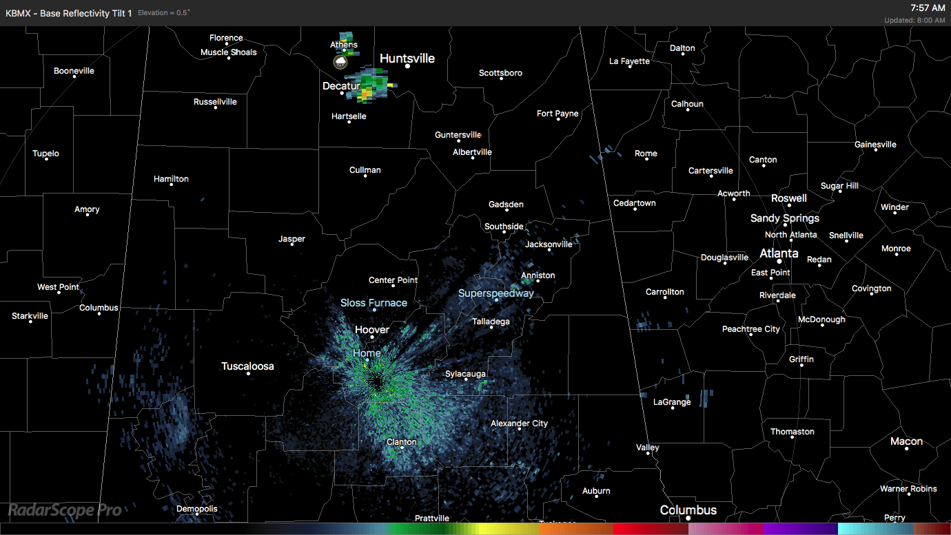
Much of Alabama waking under a clear sky but some dense fog had also formed this morning reducing visibility in some locations to less than a mile. Temperatures in most locations were close to 70 degrees to start the day. With a mix of clouds and sun after the fog burns off, the afternoon highs should rise into the upper 80s with a chance of showers. In fact, one small shower was visible on radar between Huntsville and Decatur.
The tropical Atlantic remained active with three named storms. Hurricane Jose was churning northward off the East Coast of the US producing swells on the East Coast as well as Bermuda. While the storm is forecast to remain offshore with a turn to the northeast on Wednesday, the proximity of the error cone to the eastern seaboard of the US means that all interests there should stay up with the latest forecasts on Jose should watches or warnings be required.
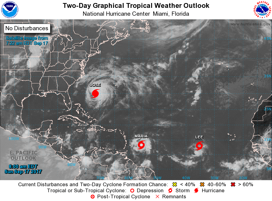
Maria was a tropical storm but forecast to intensify into a hurricane and become a major hurricane before approaching Puerto Rico on Wednesday. It will move through the northern Leeward Islands and the Virgin Islands late Monday and Tuesday ravaging an area already reeling from Irma. It is still too early to forecast with accuracy the impact that might occur to the US, but the longer range models are suggesting a turn to the north just east of the Bahamas during next weekend.
Lee was a tropical storm this morning but is not likely to remain so too long since the environment is rather hostile with substantial wind shear expected to affect it as it moves northwestward over the open Atlantic. Lee will likely be a depression by Tuesday.
For those headed to the beach, a detailed look at the weather from Fort Morgan to Panama City Beach can be found on the AlabamaWx Beach Forecast Center page. The Beach Forecast is partially underwritten by the support of Brett/Robinson Vacation Rentals in Gulf Shores and Orange Beach. Click here to see Brett/Robinson’s Hot Deals now!
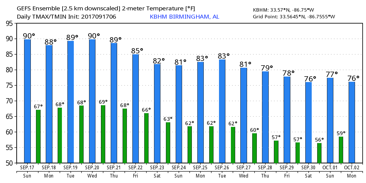
The upper air pattern over the Southeast US will feature a ridge while over the western US we will see the development of a substantial trough digging into that area by the weekend. With the upper ridge in place over us, we’ll see shower chances today, but moisture levels fall enough Monday and Tuesday to expect to see dry days with highs flirting with the 90-degree mark.
Shower chances return for the latter half of the week as moisture levels rise slightly with showers driven primarily by afternoon heating with the absence of any real weather system. Temperatures will wane a trifle as we head into the weekend falling from the upper 80s on Tuesday and into the middle 80s at the end of the week and into the weekend.
Looking into voodoo country, the GFS starts out with a split flow across the US with a trough in the western Great Lakes and one hanging back over the Southwest US. That evolves into a trough digging into the Southeast US around the 29th/30th of September suggesting some stormy weather for us then. That strong trough move on briskly with an upper ridge becoming the main feature for us by the 2nd of October.
James Spann will be up first thing on Monday morning with the next edition of the Weather Xtreme Video. Special thanks to Scott Martin for handling the video yesterday so I could participate in the WeatherReady Fest at the Discovery Cube Orange County. Have a great day and Godspeed.
-Brian-
Category: Alabama's Weather, ALL POSTS
About the Author (Author Profile)
Brian Peters is one of the television meteorologists at ABC3340 in Birmingham and a retired NWS Warning Coordination Meteorologist. He handles the weekend Weather Xtreme Videos and forecast discussion and is the Webmaster for the popular WeatherBrains podcast.Subscribe
If you enjoyed this article, subscribe to receive more just like it.


