Isolated Storms Give Way to a Dry Week
Our satellite image this morning showed clear skies across all but the southeast corner of the state with a few spots reporting reduced visibility due to some patchy fog. As we saw yesterday, we should have a mostly sunny day with only an isolated thunderstorms, but like yesterday in Cherokee County, a couple of these may produce damaging wind. Look for our afternoon highs to be in the middle and upper 80s.
Beach Weather: Beach weather will be somewhat wet through Tuesday before the weather improves. Highs will be mainly in the middle 80s with the water temperature running around 84 degrees. Click here to see the AlabamaWx Beach Forecast Center page. The Beach Forecast is partially underwritten by the support of Brett/Robinson Vacation Rentals in Gulf Shores and Orange Beach. Click here to see Brett/Robinson’s Hot Deals now!
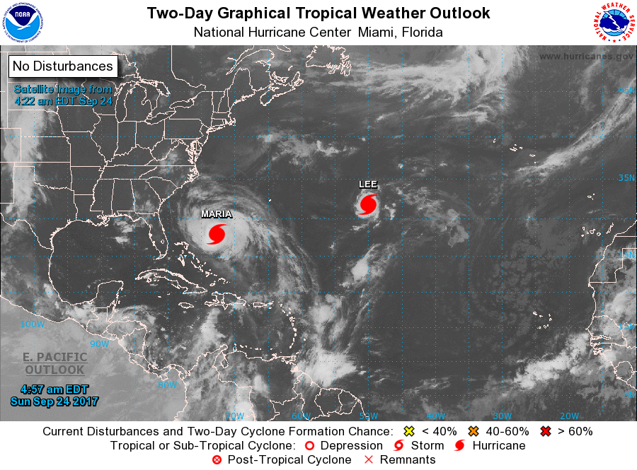
As we continue to move away from the peak of hurricane season, we have two storms in the Atlantic Basin, Maria that had weakened somewhat to a category 2 hurricane just northeast of the Bahamas and Lee, nearly dead center of the Atlantic Ocean, that had strengthened to a hurricane while it meandered out there. Maria is forecast to remain a hurricane as it tracks northward between Bermuda and the US East Coast. Wednesday it will be making its closest approach to the US as it turns northeastward off the coast of North Carolina. Swells along the US East Coast from Florida all the way to New York will present a danger until Maria begins moving away. Some direct impacts of Maria are possible as it moves closer to the US coast, so all interests along the East Coast should stay informed on the latest information about Maria.
The upper low over the Gulf Coast continued to weaken and move into the Lower Mississippi River Valley. But as I pointed out yesterday, there is a lack of moisture with precipitable water values running around 1.4 inches or less, so for Central Alabama there remains only a small chance for a few thunderstorms today. That upper air feature will dissipate from Tuesday into Wednesday and our high temperatures will remain mainly in the upper 80s.
Tuesday into Wednesday the trough over the western US separates with a chunk of it cutting off over Arizona while a chunk of it over Canada moves briskly westward. This results in a cold front moving out of the Upper Mississippi River Valley toward the Southeast US. Temperatures Wednesday remain warm with highs in the upper 80s.
The front makes its approach to the area on Thursday and Friday, but the GFS has trended even drier than what we saw on the 06Z run yesterday. With a surface low over southern Minnesota Thursday and Friday, we should see a nice drop in temperatures by the end of the week with highs dropping into the lower 80s and lows into the 60s. Unfortunately, the surface high slides eastward, so we won’t get quite as cool next weekend as it looked yesterday with highs in the lower 80s and lows in the 60s. Precipitation over the next five days through Friday morning is likely to be rather slim.
Moisture surges back into the Lower Mississippi River Valley on Sunday promising the potential for scattered showers and storms. The GFS has an upper trough along with an inverted trough at the surface along the east coast of Florida. We’re verging on voodoo country, but if this feature materializes, we’ll have to watch it for some wet weather over the Southeast US into next week.
Looking out into voodoo country, the GFS develops an upper closed low over the Ohio Valley around the 4th of October. There should be enough moisture for us to see some showers and storms. But the upper flow transitions into a zonal pattern around the 6th of October. The zonal pattern does not stick around long as the GFS builds a strong ridge over the Southeast US around the 9th of October. Climatologically, October is the driest month of the year for Central Alabama.
I’m excited to be emceeing the Ride for Kids for the Pediatric Brain Tumor Foundation again this year at Barber Motorosports Park. I think this is my fourth or fifth year to be their emcee. So if you have a motorcycle and want to help this cause, come on out today starting at 9:30 am. James Spann will be back with the next edition of the Weather Xtreme Video bright and early on Monday morning. Have a great day and Godspeed.
-Brian-
Category: Alabama's Weather, ALL POSTS
About the Author (Author Profile)
Brian Peters is one of the television meteorologists at ABC3340 in Birmingham and a retired NWS Warning Coordination Meteorologist. He handles the weekend Weather Xtreme Videos and forecast discussion and is the Webmaster for the popular WeatherBrains podcast.Subscribe
If you enjoyed this article, subscribe to receive more just like it.


