Potential Tropical System In The Gulf This Weekend
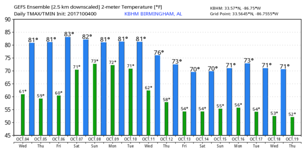
DRY THROUGH FRIDAY: Today will be the 15th consecutive day without measurable rain for Birmingham and much of North/Central Alabama, and the dry spell continues through Friday with mostly sunny warm days and fair pleasant nights thanks to an upper ridge over us.
Beyond Friday, the forecast gets complicated thanks to a tropical system that is expected to be in the Gulf of Mexico.
TROPICAL SITUATION: A tropical disturbance (Invest 90L), now over the Southwest Caribbean and off the coast of Central America, is expected to lift northward in coming days, ultimately developing into a tropical depression or storm by Friday in the southern Gulf of Mexico. From there, a north, or north/northeast motion should continue, with the system moving into the Gulf Coast Sunday.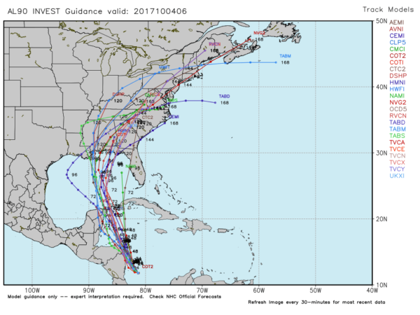
Here some important notes this morning…
*The system hasn’t even formed yet, so there is no way of knowing now where this moves onshore, or intensity at landfall. But, of course, there are ideas on the table.
*The American global model (GFS) suggests landfall on the Southeast Louisiana coast, with a motion up through eastern Mississippi that could put Alabama on the wet side of the circulation; this could bring lots of rain to our state by Saturday night and Sunday. However, the more reliable European model (ECMWF) shows a landfall east of Port St. Joe, Florida Sunday, leaving Alabama on the dry, west side of the system. I think we need to lean in that direction in our forecast.
*I would say it is doubtful that the system becomes a hurricane due to dry air west of the path, and westerly shear. But, a good chance it becomes Tropical Storm Nate. The main impact will be heavy rain along and east of the circulation center.
*If you have weekend trip planned to the Gulf Coast, I would not cancel at this point. Just understand tropical storm conditions are possible for some spots by Saturday night and Sunday. For now, it looks like the highest impact will be from Fort Walton Beach eastward to Panama City Beach and Cape San Blas Sunday. Understand, as stated above, it is simply too early to be specific and this could easily change.
*This system will long gone by the Shrimp Festival in Gulf Shores next weekend (October 12-15).
*For North/Central Alabama, for now, we will forecast a mostly dry day Saturday with just a chance of a shower by afternoon. Then, rain becomes more likely Sunday, mainly over the eastern half of the state. But, understand this can, and probably will change.
FOOTBALL WEATHER: For the high school games Friday night, the sky should be clear with temperatures falling from around 80 degrees at kickoff, through the 70s during the game.
Auburn hosts Ole Miss Saturday at Jordan-Hare Stadium (11:00a CT kickoff)… the sky will be partly sunny with temperatures rising from near 78 degrees at kickoff into the low 80s by the final whistle. A few widely scattered showers are possible.
Alabama is on the road; they will take on the Texas A&M Aggies Saturday in College Station, Texas Saturday evening (6:15p CT kickoff). The sky will be clear with temperatures falling from near 88 degrees at kickoff, to near 80 by the end of the game.
UAB’s homecoming is Saturday; the Blazers take on Louisiana Tech at Legion Field (3:00p CT kickoff)… for now we are forecasting a partly sunny sky with only widely scattered showers. About 83 degrees at kickoff, falling to near 80 by the fourth quarter.
Please keep in mind the forecast for the Auburn and UAB is subject to change due to the tropical system in the Gulf of Mexico.
NEXT WEEK: A cold front will push through Tuesday night or Wednesday with some chance of showers, followed by much cooler air for the latter half of the week. See the Weather Xtreme video for maps, graphics, and more details.
BEACH FORECAST: Click here to see the AlabamaWx Beach Forecast Center page. The Beach Forecast is partially underwritten by the support of Brett/Robinson Vacation Rentals in Gulf Shores and Orange Beach. Click here to see Brett/Robinson’s Hot Deals now!
WEATHER BRAINS: Don’t forget you can listen to our weekly 90 minute netcast anytime on the web, or on iTunes. This is the show all about weather featuring many familiar voices, including our meteorologists here at ABC 33/40.
CONNECT: You can find me on all of the major social networks…
Facebook
Twitter
Google Plus
Instagram
Pinterest
Snapchat: spannwx
Look for the next Weather Xtreme video here by 4:00 this afternoon… enjoy the day!
Category: Alabama's Weather, ALL POSTS, Weather Xtreme Videos
About the Author (Author Profile)
James Spann is one of the most recognized and trusted television meteorologists in the industry. He holds the AMS CCM designation and television seals from the AMS and NWA. He is a past winner of the Broadcast Meteorologist of the Year from both professional organizations.Subscribe
If you enjoyed this article, subscribe to receive more just like it.


