Hurricane Nate – What To Expect
Early this morning (7a CT), the center of Hurricane Nate was located near latitude 25.7 North, longitude 88.0 West. Nate is moving toward the north-northwest near 22 mph, and this general fast motion is expected to continue through tonight. A turn toward the north is forecast tomorrow morning, followed by a turn toward the north-northeast thereafter. On the forecast track, the center of Nate will move across the central and northern Gulf of Mexico today and will make landfall along the central U.S. Gulf coast tonight, most likely on the Mississippi coast.
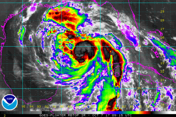
Reports from NOAA and Air Force Reserve Hurricane Hunter aircraft indicate that maximum sustained winds have increased to near 85 mph with higher gusts. Some additional strengthening is possible before Nate makes landfall along the northern Gulf coast.
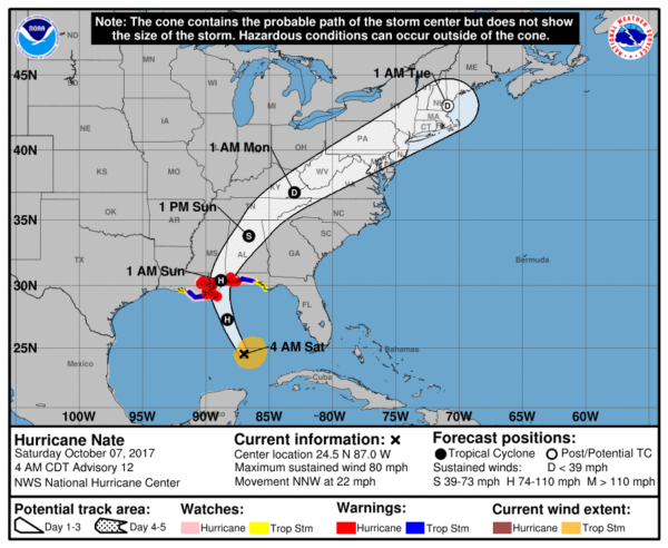
A Hurricane Warning is in effect for…
* Grand Isle Louisiana to the Alabama/Florida border (including all of the Alabama Gulf Coast)
* Metropolitan New Orleans and Lake Pontchartrain
A Storm Surge Warning is in effect for…
* Morgan City Louisiana to the Okaloosa/Walton County Line Florida
* Northern and western shores of Lake Pontchartrain
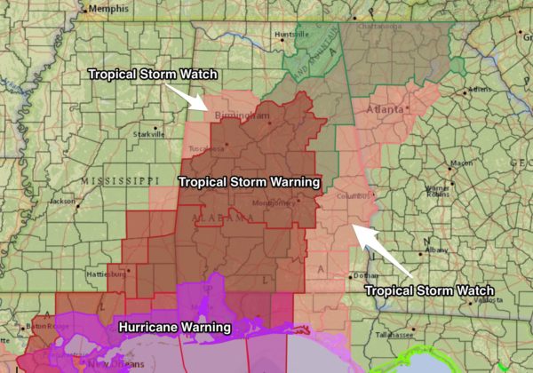
A Tropical Storm Warning is in effect for…
* Lake Maurepas
* West of Grand Isle to Morgan City Louisiana
* East of the Alabama/Florida border to the Okaloosa/Walton County Line.
A Hurricane Watch is in effect for…
* Lake Maurepas
* East of the Alabama/Florida border to the Okaloosa/Walton County Line
* West of Grand Isle to Morgan City Louisiana
A Storm Surge Watch is in effect for…
* East of the the Okaloosa/Walton County Line to Indian Pass Florida
A Tropical Storm Watch is in effect for…
* East of the Okaloosa/Walton County Line to Indian Pass Florida
* West of Morgan City to Intracoastal City Louisiana
A Tropical Storm Warning has been issued for inland Alabama as far north as Tuscaloosa, Birmingham, Pell City, and Talladega…
GULF COAST: Conditions will deteriorate on the Central Gulf Coast today, with increasing wind and rain. The combination of a dangerous storm surge and the tide will cause normally dry areas near the coast to be flooded by rising waters moving inland from the shoreline. The water is expected to reach the following heights above ground if the peak surge occurs at the time of high tide…
Morgan City, Louisiana to the mouth of the Mississippi River…4 to 6 ft
Mouth of the Mississippi River to the Alabama/Florida border…5 to 9 ft
Alabama/Florida border to the Okaloosa/Walton County Line…4 to 6 ft
Okaloosa/Walton County Line to Indian Pass, Florida…2 to 4 ft
Indian Pass to Crystal River, Florida…1 to 3 ft
The deepest water will occur along the immediate coast near and to the east of the landfall location, where the surge will be accompanied by large and destructive waves. Surge-related flooding depends on the relative timing of the surge and the tidal cycle, and can vary greatly over short distances.
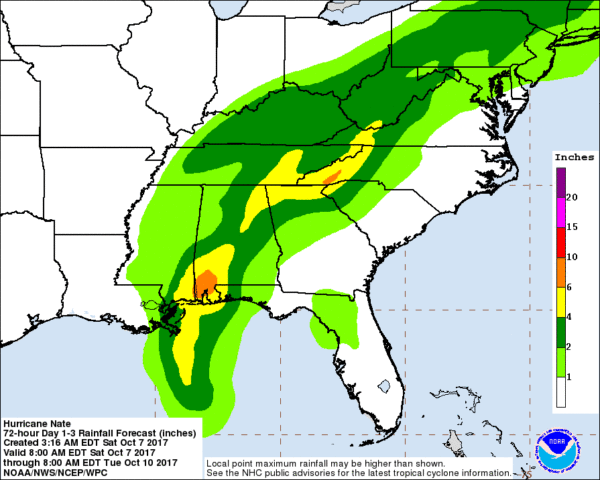
In addition to storm surge issues, rain amounts on the Gulf Coast will be in the 3 to 6 inch range, and a few tornadoes are possible as well.
The City of Gulf Shores, in conjunction with the City of Orange Beach, will enforce a mandatory curfew beginning at 8:00 tonight through 6 a.m. tomorrow. This curfew is in place for the safety of citizens due to expected hurricane-force winds during this time. All vehicles should stay off of roadways until the curfew has expired. Local businesses are asked to prepare and adjust for proper closing times to allow for employees to return home safely before the curfew begins.
Conditions will improve on the coast tomorrow as Nate moves to the north.
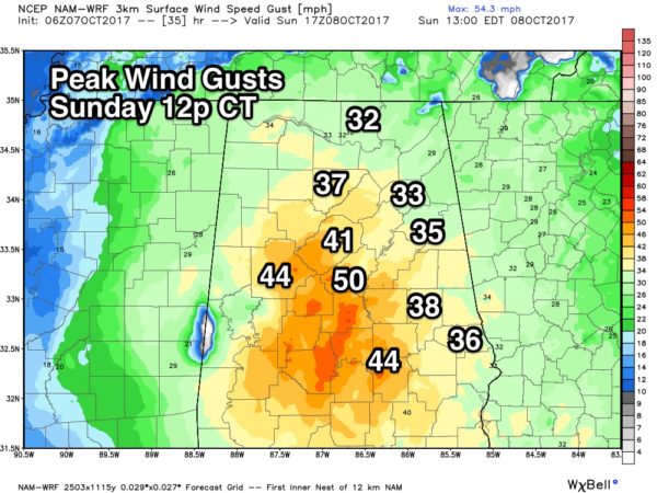
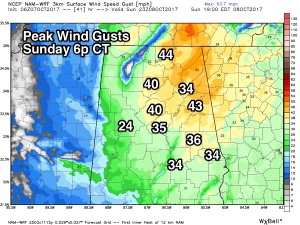
NORTH/CENTRAL ALABAMA: Clouds will increase today, but we only expect a few scattered showers. Wind and rain will increase after midnight tonight and during the day tomorrow. Sustained winds will ramp up into the 30-50 mph range tomorrow, with potential for higher gusts on ridges. This will be sufficient for tree damage and power outages…
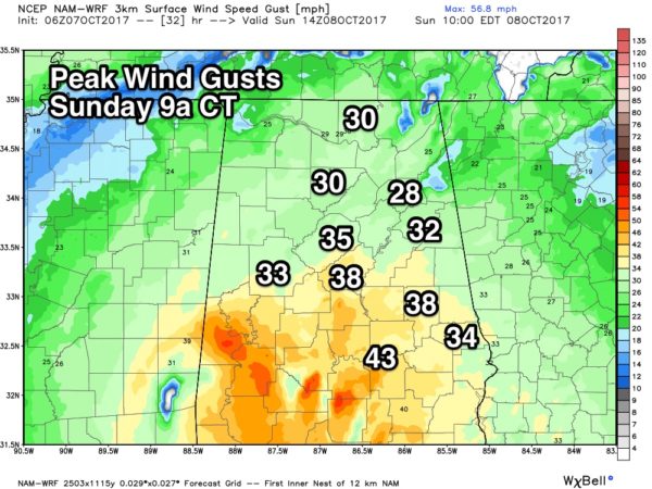
Rain amounts of 2-4″ are likely, with potential for locally higher amounts. A flash flood watch has been issued for much of Central and Northeast Alabama.
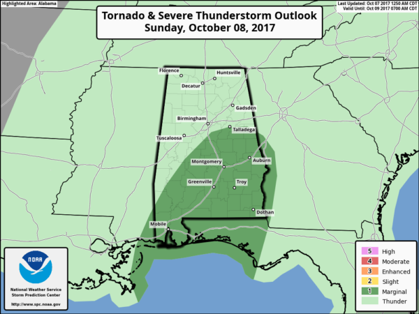
And, a few isolated tornadoes are possible tomorrow, generally east and south of a line from Linden to Alabaster to Talladega to Wedowee.
Wind and rain will slowly diminish tomorrow night.
Keep an eye on the blog for frequent updates this weekend!
Category: Alabama's Weather, ALL POSTS, Tropical
About the Author (Author Profile)
James Spann is one of the most recognized and trusted television meteorologists in the industry. He holds the AMS CCM designation and television seals from the AMS and NWA. He is a past winner of the Broadcast Meteorologist of the Year from both professional organizations.Subscribe
If you enjoyed this article, subscribe to receive more just like it.


