Nate Strengthens, Moves Closer
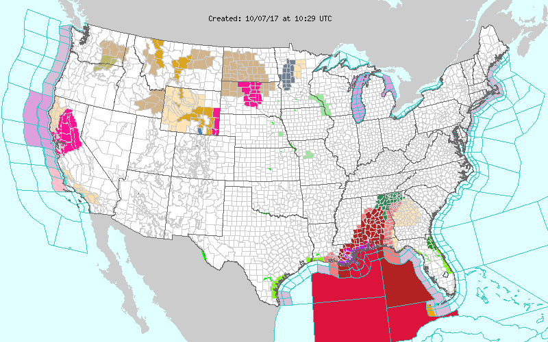
All eyes this morning are watching Hurricane Nate in the southern Gulf of Mexico which is making a beeline for the Central Gulf Coast. Here is a list of the warnings and watches covering Alabama:
A Hurricane Warning and Storm Surge Warning are in effect for Baldwin (Central, Coastal, Inland) and Mobile counties (Central, Coastal, Inland).
A Tropical Storm Warning is in effect for Butler, Choctaw, Clarke, Conecuh, Covington, Crenshaw, Escambia, Greene, Monroe, Perry, Washington, Wilcox, Autauga, Bibb, Chilton, Coosa, Dallas, Elmore, Greene, Hale, Jefferson, Lowndes, Marengo, Montgomery, Perry, Shelby, St. Clair, Sumter, Talladega, and Tuscaloosa counties.
A Tropical Storm Watch is in effect for Barbour, Blount, Bullock, Calhoun, Chambers, Cherokee, Clay, Cleburne, Coffee, Dale, Etowah, Fayette, Geneva, Greene, Hale, Jefferson, Lee, Macon, Pickens, Pike, Randolph, Russell, Tallapoosa, and Walker counties.
A Flash Flood Watch is in effect for Baldwin, Butler, Choctaw, Clarke, Conecuh, Escambia, Mobile, Monroe, Washington, Wilcox, Marshall, Jackson, DeKalb, Blount, Etowah, Calhoun, Cherokee, Cleburne, Tuscaloosa, Jefferson, Shelby, St. Clair, Talladega, Clay, Sumter, Greene, Hale, Perry, Bibb, Chilton, Coosa, Tallapoosa, Marengo, Dallas, Autauga, Lowndes, Elmore, and Montgomery counties.
Please see other posts on this blog for additional details on the impacts of Hurricane Nate. And be sure to check back here often as we update the information on Nate.
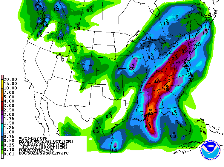
Nate is forecast to move into the Central Gulf Coast just to the west of Mobile, AL, around 1 am on Sunday. This location can still change as the storm approaches the coast – nothing with tropical systems is ever set completely. The storm is forecast to track to the northeast across Central and Northeast Alabama. Areas along and to the right of the track an expect to see very heavy rain with rainfall totals of 2 to 4 inches possible with amounts potentially reaching 5 inches in places. Severe weather with isolated tornadoes will be possible along and just to the east of the track over the Louisiana-Mississippi-Alabama Gulf coasts areas including the western edge of Northwest Florida. The risk continues into Day 2 extending northward across much of southern and Central Alabama.
Aloft, a fast moving upper trough moves into New England on Sunday while another trough digs into the Northwest US. That second trough digs into the 4-corners area on Monday while Nate moves well away but leaves high moisture levels behind. This keeps us in rather high chances for rain through Tuesday.
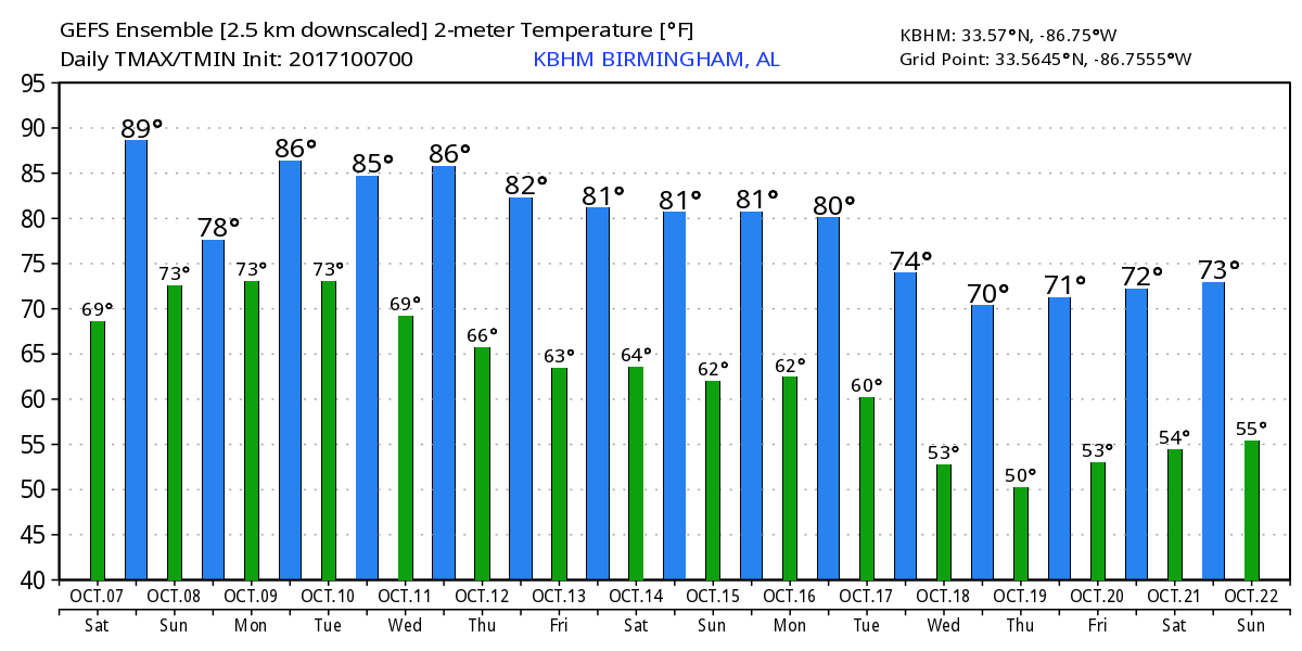
The 4-corners trough ejects northeastward on Tuesday and Wednesday reaching the eastern Great Lakes by Wednesday. This should finally drag a front into and across the Southeast US on Wednesday lowering our rain chances and sweeping the moisture out of here. The upper pattern goes into a ridge configuration so the latter part of the week will be warm once again with highs in the middle 80s, even pushing the upper 80s some. The latter part of the week should be dry along with the warmth.
Looking out into voodoo country, the upper ridge weakens as a strong trough moves into the western Great Lakes around October 16th. That trough moves into the eastern US around the 18th and sticks around through the 21st. While mainly a dry pattern, it does suggest temperatures falling somewhat as you would expect into middle portions of October.
I will be heading out in the ABC 3340 Storm Chaser in a couple of hours to welcome Nate to Alabama. You can follow along on this tropical adventure by watching the video on Facebook Live, just search for AB 3340 Storm Chaser. I do not believe I will be in a position to produce a Weather Xtreme Video on Sunday morning, but there will be lots of notes here as Nate pays a visit to Alabama. Godspeed.
-Brian-
 .
.
Category: Alabama's Weather, ALL POSTS
About the Author (Author Profile)
Brian Peters is one of the television meteorologists at ABC3340 in Birmingham and a retired NWS Warning Coordination Meteorologist. He handles the weekend Weather Xtreme Videos and forecast discussion and is the Webmaster for the popular WeatherBrains podcast.Subscribe
If you enjoyed this article, subscribe to receive more just like it.


