Saturday Morning Update On Central Alabama’s Weather
CURRENT LIST OF WATCHES & WARNINGS ALONG THE GULF COAST

A Hurricane Warning is in effect for…
* Grand Isle Louisiana to the Alabama/Florida border
* Metropolitan New Orleans and Lake Pontchartrain
A Storm Surge Warning is in effect for…
* Morgan City Louisiana to the Okaloosa/Walton County Line Florida
* Northern and western shores of Lake Pontchartrain
A Tropical Storm Warning is in effect for…
* Lake Maurepas
* West of Grand Isle to Morgan City Louisiana
* East of the Alabama/Florida border to the Okaloosa/Walton County Line.
A Hurricane Watch is in effect for…
* Lake Maurepas
* East of the Alabama/Florida border to the Okaloosa/Walton County Line
* West of Grand Isle to Morgan City Louisiana
A Storm Surge Watch is in effect for…
* East of the the Okaloosa/Walton County Line to Indian Pass Florida
A Tropical Storm Watch is in effect for…
* East of the Okaloosa/Walton County Line to Indian Pass Florida
* West of Morgan City to Intracoastal City Louisiana
CURRENT LIST OF WATCHES & WARNINGS FOR NORTH/CENTRAL ALABAMA
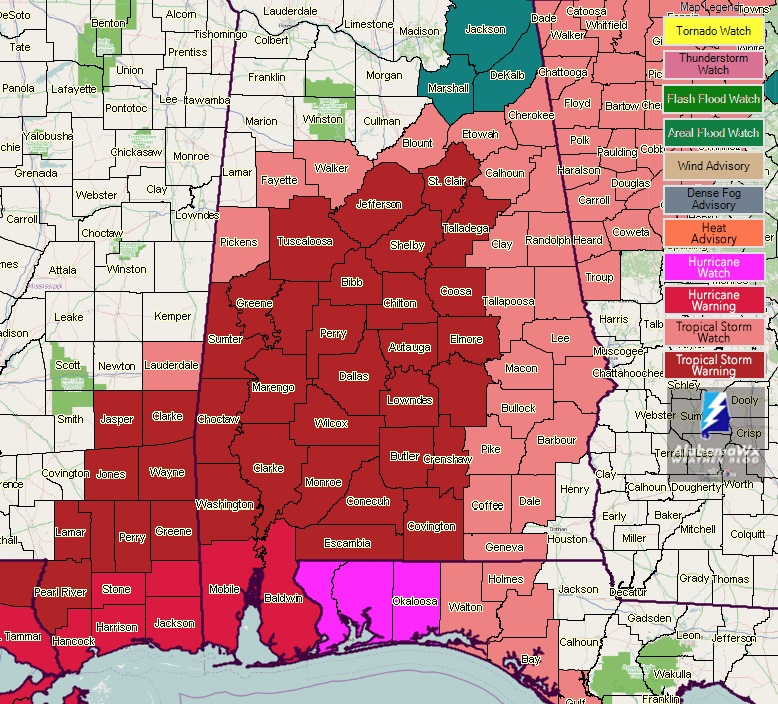
A Tropical Storm Warning is in effect until further notice for…
* Autauga, Bibb, Butler, Chilton, Choctaw, Clarke, Conecuh, Coosa, Covington, Crenshaw, Dallas, Elmore, Escambia, Greene, Hale, Jefferson, Lowndes, Marengo, Monroe, Montgomery, Perry, Shelby, St. Clair, Sumter, Talladega, Tuscaloosa, Washington, and Wilcox counties
A Tropical Storm Watch is in effect until further notice for…
* Barbour, Blount, Bullock, Calhoun, Chambers, Cherokee, Clay, Cleburne, Coffee, Dale, Etowah, Fayette, Geneva, Lee, Macon, Pickens, Pike, Randolph, Russell, Tallapoosa, and Walker counties
A Flash Flood Watch is in effect in Central Alabama from Saturday evening to Sunday evening for…
* Autauga, Bibb, Blount, Calhoun, Cherokee, Chilton, Clay, Cleburne, Coosa, Dallas, Elmore, Etowah, Greene, Hale, Jefferson, Lowndes, Marengo, Montgomery, Perry, Shelby, St. Clair, Sumter, Talladega, Tallapoosa, and Tuscaloosa counties
A Flash Flood Watch is in effect In North Alabama from Sunday morning to Monday morning for…
* De Kalb, Jackson, and Marshall counties
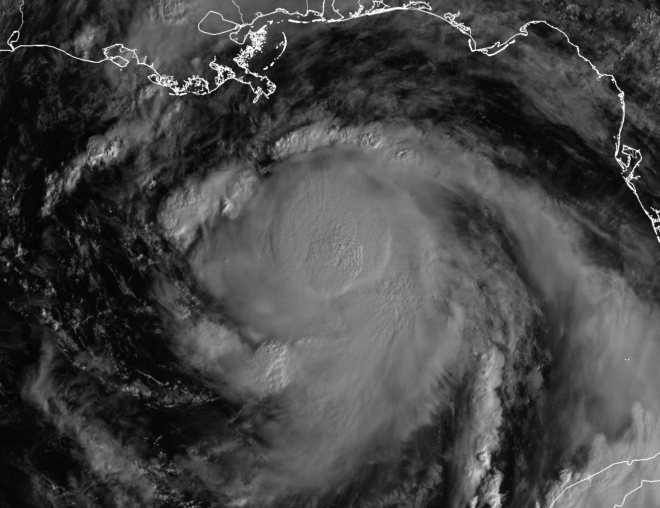
THE LATEST ON HURRICANE NATE
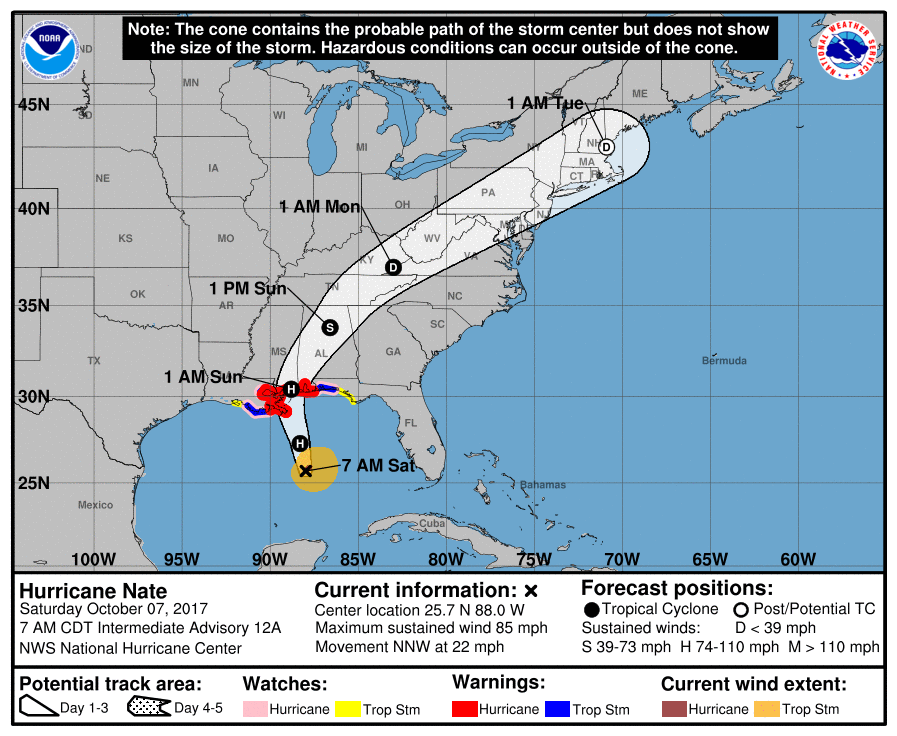
As of the 7:00 AM update from the National Hurricane Center, maximum sustained winds are up to 85 MPH, while the minimum central pressure is down to 986mb. Nate is still moving to the north-northwest at 22 MPH. The current forecast track still has landfall of the center just after midnight tonight on the Mississippi coast very close to Biloxi as a strong category 1 storm with maximum sustained winds at 90 MPH.
A local State of Emergency has been issued for Gulf Shores and A voluntary evacuation is in effect along parts of Baldwin County, and people with RVs, campers, mobile homes, non-residents, and people in flood-prone areas are being encouraged to leave the area until the storm passes. A curfew is in effect this evening for Gulf Shores and Orange Beach starting at 8:00 PM tonight and going through 6:00 AM Sunday. All beaches and state parks will be closed to the public until further notice. Jack Edwards National Airport will close tonight at 8:00 PM.
On the current forecast track from the NHC, conditions will start to deteriorate along the beaches this afternoon and evening as the outer bands will start reaching the shoreline. Rip currents and dangerous surf have already started along the coast and no one should be in the water at all at this point.
The worst of the hurricane will reach the Alabama Gulf Coast tonight and persists through the pre-dawn hours on Sunday. Sustained tropical force winds with hurricane force wind gusts will be likely tonight, along with very heavy rainfall, and a few tornadoes and waterspouts can be expected. Flooding along the beaches and just inland is likely to occur, with storm surge of 3-5 feet above ground expected, along with the heavy rain.
Conditions will gradually start to improve after the center passes by and moves north of the beaches. By Sunday evening, conditions will be much better and rainfall will be scattered in nature.
HOW WILL NATE AFFECT CENTRAL ALABAMA
Conditions for Central Alabama will really start to deteriorate during the early morning hours on Sunday, as heavy rain and gusty winds start to move in from still Hurricane Nate. As Nate moves northeastward through the area, gradual weakening will occur, but strong winds can still be expected all the way through the area.
By 1:00 PM Sunday, the center will be just northeast of the Birmingham area as a tropical storm. At that time, maximum sustained winds are forecast to be around 50 MPH. The forward speed of Nate will really start to increase to the northeast and the center will be out of the area by 3:00-4:00 PM.
Winds: For much of the central parts of the area, we could see wind gusts of 40-60 MPH, with higher gusts up to 70 MPH possible in the southwestern parts. For the extreme eastern and western parts of the area, wind gusts of 20-40 MPH will be possible. Fallen trees and powerlines are possible, and some communities could lose power. If this occurs, it may take a few hours to get the power restored due to the strong winds and dangerous conditions.
Tornadoes: The main risk for tornadoes at this point will be south of a line from Demopolis to Alabaster to Talladega to Ranburne. No tornadoes are expected for locations west of the center as Nate progresses through the area.
Rain: Heaviest totals will be along and east of the I-20/59 and I-59 corridors, where 3-4 inches are possible. Totals will drop off as you are farther away from the center where 1-3 inches are possible. Locations in the southwestern part of the area could see up to 5-6 inches. Flooding is a possibility.
We will continue to have updates throughout today and tomorrow here on the blog. Be sure to have your safety kits ready, fresh batteries in your radios and flashlights, a full tank in the generators, and a fully-charged cellphone on standby.
Category: Alabama's Weather, ALL POSTS
About the Author (Author Profile)
Scott Martin is an operational meteorologist, professional graphic artist, musician, husband, and father. Not only is Scott a member of the National Weather Association, but he is also the Central Alabama Chapter of the NWA president. Scott is also the co-founder of Racecast Weather, which provides forecasts for many racing series across the USA. He also supplies forecasts for the BassMaster Elite Series events including the BassMaster Classic.Subscribe
If you enjoyed this article, subscribe to receive more just like it.


