Nate Will Bring Significant Impacts to Central Alabama Late Tonight, Especially on Sunday
It has the feel of an approaching tropical cyclone out there today across Central Alabama. I have been feeling those since 1969, when Hurricane Camille made landfall when I was 7 years old. I remember Hurricane Edith in 1971 which came right across Central Alabama as a tropical depression. There was Agnes in 1972, Carmen in 1974, Eloise in 1975. Then Frederic in 1979, Danny with its tornadoes in 1985, a scary Opal in 1995 and a very wet Danny in 1997. Isidore in 2002 was memorable, as was Ivan in 2004, the terrible storms of 2005 (Dennis Katrina and Rita that all impacted Alabama) and Fay in 2008 and Claudette in 2009. And then there was Irma from this year.
Hurricane Nate will bring strong winds, heavy rains and tornadoes to Central Alabama. Let’s break down the timing and intensity of the impacts:
RAIN
Precipitable water values are running nearly 2.3 inches across Southwest Alabama this afternoon and over two inches across South Central Alabama. This is 180-200% above normal for this time of year!
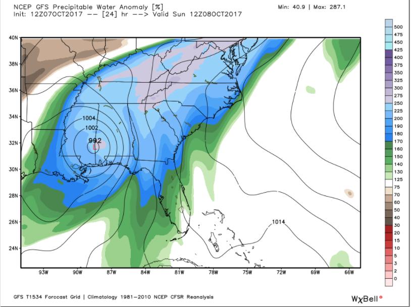
These values will increase to 2.5 inches across most of Central Alabama by morning, which is going to be 225-250% above normal! With a fast-moving tropical storm moving up into Central Alabama, you would expect heavy rainfall to result.
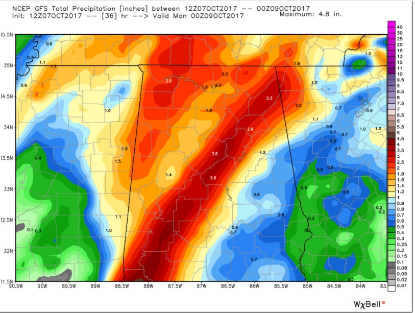
The good news is that the speed of forward motion will limit the duration of the heavy rain. Still, a band of 3-4 inch amounts appears likely across Central Alabama near and just east of the track of the center of the tropical storm.
Here are official QPF totals from the Weather Prediction Center:
As far as timing, the first light feeder band has already lifted across Central Alabama. It extends from Lamar and Fayette counties through Cullman, Blount, Etowah and Cherokee Counties at this hour.
Rain is already increasing over Southwest Alabama. This rain will move into Central Alabama, mainly west of I-65 by 6 p.m. this evening.
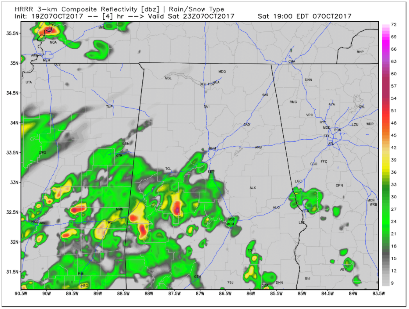
It will overspread the area during the evening. This is what the radar could look like by 9 p.m.
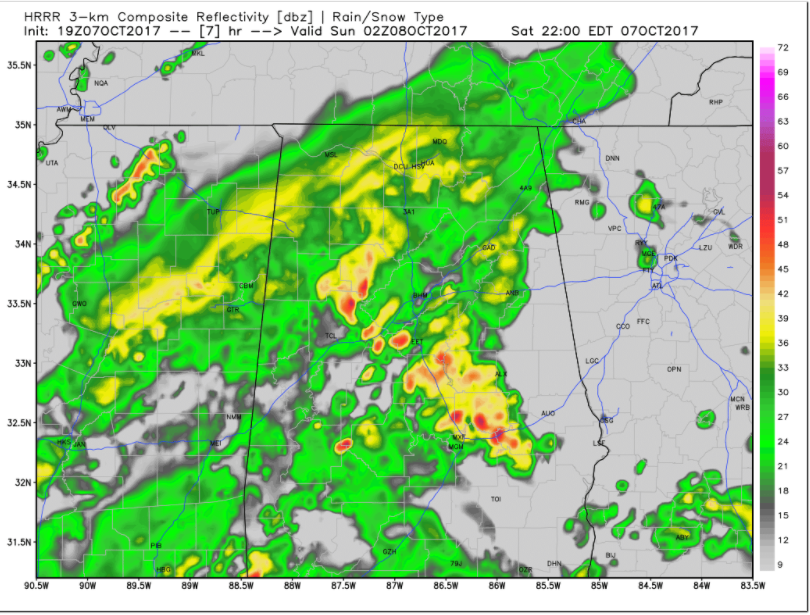
Heavy rain will lift into North Alabama through midnight. By 5 a.m. more heavy rain will cover much of Central Alabama with the core of what may still be Hurricane Nate entering the southwestern part of the area. That core will be moving into Central Alabama by 7 a.m. spreading across areas along and south of I-59 through the morning hours and impacting Tuscaloosa and Birmingham.
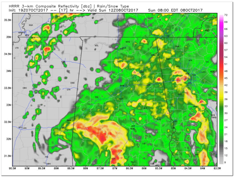
FLash flood watches are in effect. We have been very dry lately, but flooding will be a good bet.
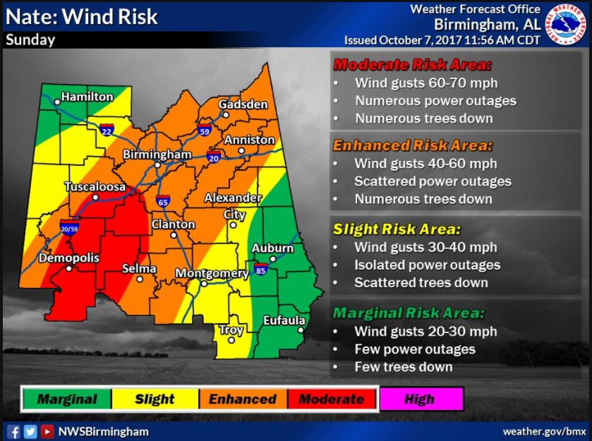
WIND
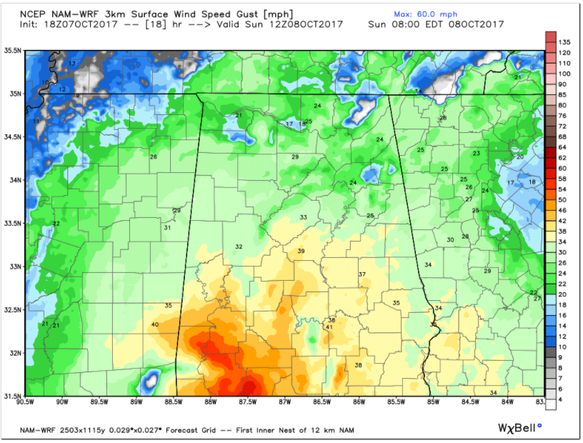
Nate should be a hurricane all the way into Southwest Alabama but should remain a strong tropical storm well into Central Alabama. Wind gusts to 50-60 mph could impact much of Central Alabama as the system moves to the northeast across the state.
Winds will begin to gust to 20-25 mph over Central Alabama by early evening.
Here are projected wind gusts from the 3km NAM at 7 a.m:
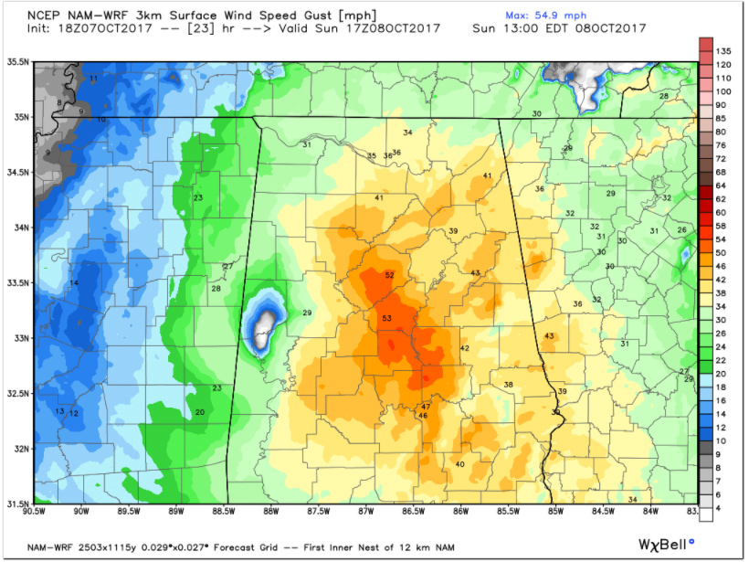
At noon:
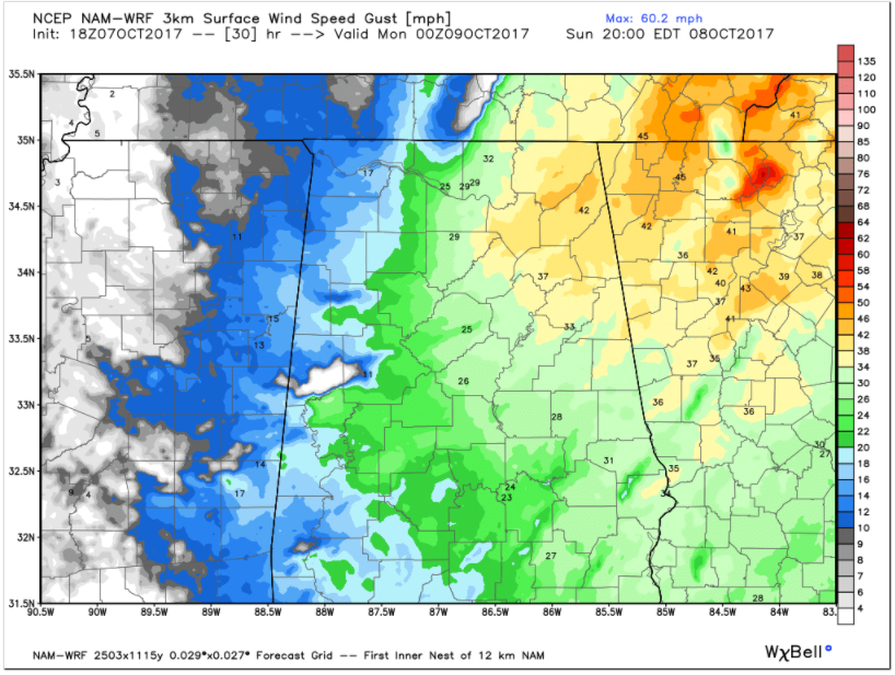
And at 7 p.m. as winds slowly diminish over Central Alabama, but remain strong over Northeast Alabama.
Tropical storm warnings cover much of the area. Wind advisories are in effect where they aren’t.
There will be power outages and trees down across the area. Here is a look at where th emost widespread impacts may be felt:
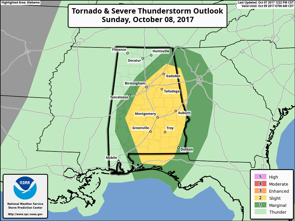
TORNADOES
Brief tornadoes will form tomorrow along convective bands on the eastern side of the track of Nate, especially if sunshine can break out between the bands.
Here is the severe weather threat area for tomorrow:
Stay with AlabamaWX for constant updates throughout the night and tomorrow.
Category: Alabama's Weather, ALL POSTS
About the Author (Author Profile)
Bill Murray is the President of The Weather Factory. He is the site's official weather historian and a weekend forecaster. He also anchors the site's severe weather coverage. Bill Murray is the proud holder of National Weather Association Digital Seal #0001 @wxhistorianSubscribe
If you enjoyed this article, subscribe to receive more just like it.


