Conditions Along The Gulf Coast Continue To Deteriorate
WHAT’S HAPPENING ACROSS THE ALABAMA GULF COAST
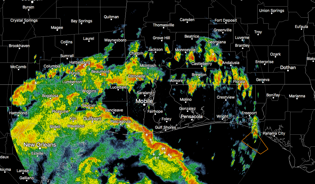
Currently across the Alabama Gulf Coast, another feeder band from Hurricane Nate is moving onshore. As we have already seen with an earlier band, a few waterspouts have formed that have prompted the issuance of the first tornado warning for Baldwin County at 2:15 PM. There are a few heavier downpours with some lightning out there, but at this point no circulations are being picked up on Mobile radar.
Winds at this point across southwestern Alabama are not too bad, with peak gusts in the 20-25 MPH neighborhood. Those numbers will continue to increase as we get further into the late afternoon and evening hours, as the center of Nate continues its approach.
WATCHES & WARNINGS
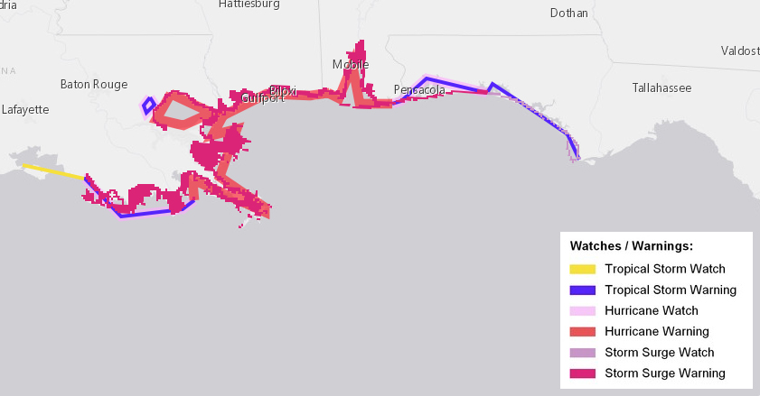
A Hurricane Warning is in effect for…
* Grand Isle Louisiana to the Alabama/Florida border
* Metropolitan New Orleans and Lake Pontchartrain
A Storm Surge Warning is in effect for…
* Morgan City Louisiana to the Okaloosa/Walton County Line Florida
* Northern and western shores of Lake Pontchartrain
A Tropical Storm Warning is in effect for…
* Lake Maurepas
* West of Grand Isle to Morgan City Louisiana
* East of the Alabama/Florida border to Indian Pass Florida
A Hurricane Watch is in effect for…
* Lake Maurepas
* East of the Alabama/Florida border to the Okaloosa/Walton County Line
* West of Grand Isle to Morgan City Louisiana
A Storm Surge Watch is in effect for…
* East of the Okaloosa/Walton County Line to Indian Pass Florida
A Tropical Storm Watch is in effect for…
* West of Morgan City to Intracoastal City Louisiana
WHAT CAN BE EXPECTED THROUGHOUT TONIGHT & INTO TOMORROW MORNING
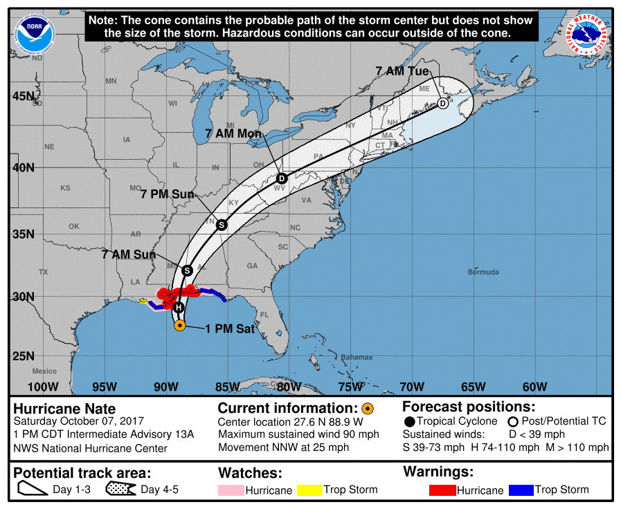
Tropical storm force winds will be likely along the coast starting within a couple of hours and persist into Sunday morning. Depending on where the center makes landfall later tonight, hurricane force winds could be possible, mainly closest to the center. At this point with the latest NHC track, the center will make landfall just east of Biloxi around midnight as a category 2 hurricane, with maximum sustained winds around 105-110 MPH.
Maximum storm surge will occur late tonight into early Sunday morning, pretty close to when high tide occurs a little after midnight. The Mobile Bay region and coastal Baldwin County could see storm surge heights of 5-10 feet above normally dry ground. The western Florida Panhandle could see 3-6 feet above normally dry ground.
Along with the storm surge, life-threatening rip currents and surf will be battering the beaches from now until at least Sunday afternoon. If you have no business being in the water, DON’T GO IN. All beaches in Alabama are closed to the public, including the state park property.
With the current forecast landfall to occur just east of Biloxi, all of the Alabama and western Florida Panhandle will have an elevated threat for tornadoes from now until around Sunday morning. Once the center passes by, the tornado threat will be over.
We can also see rainfall totals of 3-6 inches with heavier localized amounts possible, which could lead or help exacerbate flooding.
EVACUATIONS & CLOSURES
The City of Gulf Shores has issued an evacuation order for all properties along West Beach Boulevard located west of Little Lagoon Pass/Lee Callaway Bridge, along with the West Beach areas between West 8th Street and the Little Lagoon Pass/Lee Callaway Bridge. Once sustained winds reach 45 MPH, all access to the W.C. Holmes Bridge on State Highway 59 will be restricted, which is expected to occur around 7:00 PM tonight.
A voluntary evacuation is in effect along the rest of the Baldwin County beaches. People with RVs, campers, mobile homes, non-residents, and people in flood-prone areas are being encouraged to leave the area until the storm passes.
For Gulf Shores and Orange Beach, a curfew goes into effect later tonight at 8:00 PM until 6:00 AM Sunday morning. Baldwin County has opened the Baldwin County Coliseum in Robertsdale for anyone seeking shelter. Jack Edwards National Airport is now closed until further notice.
About the Author (Author Profile)
Scott Martin is an operational meteorologist, professional graphic artist, musician, husband, and father. Not only is Scott a member of the National Weather Association, but he is also the Central Alabama Chapter of the NWA president. Scott is also the co-founder of Racecast Weather, which provides forecasts for many racing series across the USA. He also supplies forecasts for the BassMaster Elite Series events including the BassMaster Classic.Subscribe
If you enjoyed this article, subscribe to receive more just like it.


