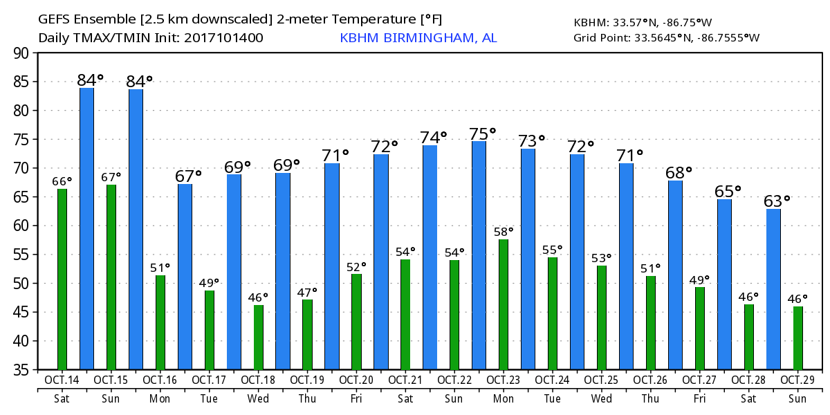
Warm Today, Sunday, Cooler Monday
The Southeast US is starting out somewhat split with clouds covering the Carolinas and Georgia while clear weather prevails across the western half of the Southeast. For Alabama, today will be another dry day with very warm afternoon highs in the middle 80s, nearly 10 degrees warmer than the 30-year averages suggest (76 is the 30-year average high for the middle of October). But moisture levels will move upward today and Sunday ahead of a cold front that is projected to move through Alabama Sunday. The front and associated upper trough will certainly bring some forcing for showers and thunderstorms, but moisture will be a little shy, so while showers and thunderstorms are likely to occur, coverage will keep rain chances to around 30 to 40 percent. The afternoon highs will be in the middle 80s for the last time in at least a week. The front will pass out of Alabama by Monday morning as clearing moves from the northwest to the southeast.
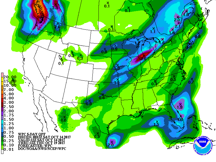
Rainfall for the next five days will be limited to what falls from Sunday afternoon through Monday morning. With precipitable water values mainly at or below 1.7 inches for the northern half of the state, rainfall will be fairly light with spotty amounts of a quarter of an inch or less.
RACE WEEKEND AT TALLADEGA
Warm, dry weather today forecast today for Talladega with highs in the 80s. There is a 30 percent chance for showers for the Alabama 500 Sunday, but we still project afternoon temperatures in the low to mid 80s; a few showers are more likely Sunday night ahead of a cold front.
FOOTBALL WEATHER
Alabama will host the Arkansas Razorbacks this evening with a 6:15 pm CDT kickoff at Bryant-Denny Stadium in Tuscaloosa for homecoming. The sky will be partly cloudy and the temperature will be about 82 degrees at kickoff falling to near 75 by the final whistle. Auburn travels to Baton Rouge to take on LSU this afternoon with a 2:30 pm CDT kickoff. The game will be played under a sunny sky; the temperature will be close to 88 degrees at kickoff falling back into the low 80s by the fourth quarter. UAB will host Middle Tennessee at Legion Field in Birmingham this evening with a 5:30 pm CDT kickoff. The weather is expected to be partly cloudy with temperatures falling from near 83 at kickoff into the 70s by the second half.
TROPICS
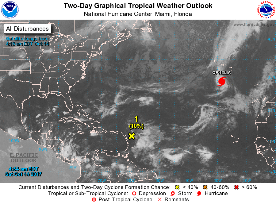
A disturbance east of the Leeward Islands has only a low chance of developing in coming days; if anything forms there, it will move north and seems to be no threat to land. Hurricane Ophelia is still in the eastern Atlantic; it will threaten Ireland and the U.K. early next week as a post-tropical cyclone. Elsewhere, the rest of the Atlantic basin is quiet.
BEACH FORECAST: Click here to see the AlabamaWx Beach Forecast Center page. The Beach Forecast is partially underwritten by the support of Brett/Robinson Vacation Rentals in Gulf Shores and Orange Beach. Click here to see Brett/Robinson’s Hot Deals now!
WEEK AHEAD
The upper trough will basically beat the ridge down by Monday and Tuesday as we establish a trough over the eastern US. Monday will be much cooler with highs only in the lower 70s and humidity levels way down as dew points are forecast to plunge into the 40s with a nice northwesterly flow aloft. The upper trough will stick with us into mid-week as a surface high develops and moves across the Middle Mississippi River Valley and into the southern Appalachians by Wednesday. Tuesday and again Wednesday morning will some of the coldest lows so far this Fall season as readings dip into the 40s. According to National Weather Service records, the lowest temperature at the Birmingham Shuttlesworth International Airport so far in the Fall of 2017 has been 51 back on September 7th.
Upper ridging takes place for the latter portion of the week which strong upper troughs impact the western US. This will keep a surface high pressure system in place across the eastern half of the country, so I expect to see temperatures rise into the middle and upper 70s for the days from Wednesday through Saturday. Lows will also warm nicely as daily values remain in the 50s.
Looking further out into voodoo country, the GFS maintains troughiness over the eastern US keeping us near or slightly below seasonal averages. There is a brief weak ridging pattern around the 27th of October, but that ridging does not last long as the pattern moves back to an eastern US trough by the 29th of October. Overall the pattern looks fairly dry in the absence of any kind of good southerly flow.
WEATHER BRAINS: Don’t forget you can listen to our weekly 90 minute netcast anytime on the web, or on iTunes. This is the show all about weather featuring many familiar voices, including our meteorologists here at ABC 33/40.
I’ve very excited to have been invited to be a judge in the chili cook-off at Mt. Cheaha late this morning. If you are in the area, be sure to come by and say hello. I’ll have the next Weather Xtreme Video posted here around 7 am or so on Sunday. Enjoy what may be one of the warmest days we’ll see here for a while. Godspeed.
-Brian-
Category: Alabama's Weather, ALL POSTS
About the Author (Author Profile)
Brian Peters is one of the television meteorologists at ABC3340 in Birmingham and a retired NWS Warning Coordination Meteorologist. He handles the weekend Weather Xtreme Videos and forecast discussion and is the Webmaster for the popular WeatherBrains podcast.Subscribe
If you enjoyed this article, subscribe to receive more just like it.


