Warm but Turning Much Cooler Monday
Clouds wedged into Alabama across the northern half yesterday morning and stuck around just about all day contributing to my forecast bust. Instead of the warm, sunny day, it was a cloudy, somewhat dreary and cool day. Sort of a sample of the colder air forecast to arrive Monday. This morning clouds cover a portion of Central and South Alabama with the front poised in northeastern Arkansas to enter the state of Alabama this afternoon. Some scattered showers are possible to develop in the warm and relatively moist air mass ahead of the front, but most of us will get our best shot at rain as the front moves across Central Alabama this evening and early Monday morning. The front is forecast to move briskly through the Southeast US as the upper trough moves across the eastern Great Lakes. Temperatures today will be in the lower 80s, and it sure looks like this will be the last really warm day for quite some time.
RACE WEEKEND AT TALLADEGA
Warm weather today for Talladega with highs in the 80s, but there is a 30 percent chance for showers for the Alabama 500 Sunday; showers are more likely Sunday night ahead of a cold front.
TROPICS
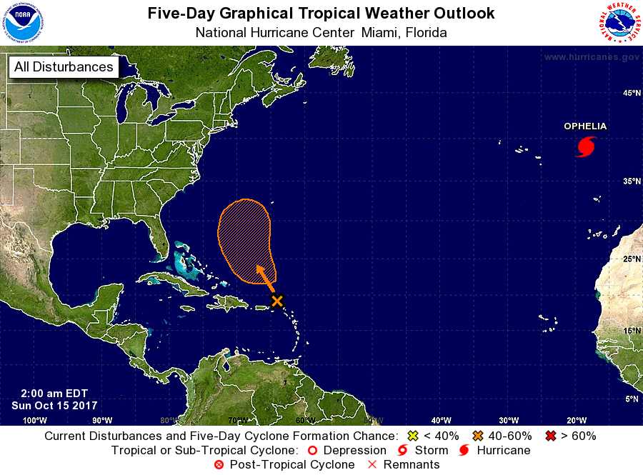
A disturbance east of the Leeward Islands has only a low chance of developing in coming days; if anything forms there, it will move north and seems to be no threat to land. Hurricane Ophelia is still in the eastern Atlantic; it is taking aim at Ireland and the U.K. as a post-tropical cyclone. Elsewhere, the rest of the Atlantic basin is quiet.
BEACH FORECAST: Click here to see the AlabamaWx Beach Forecast Center page. The Beach Forecast is partially underwritten by the support of Brett/Robinson Vacation Rentals in Gulf Shores and Orange Beach. Click here to see Brett/Robinson’s Hot Deals now!
THE WEEK AHEAD
Rainfall for the round of showers and thunderstorms with the front appears to be a little greater than we were forecasting yesterday. Because of the showery nature of the precipitation, not everyone will see the same amount of rain, but it looks like many locations should see rainfall amounts around a half inch. Showers and storms should be moving through pretty quickly, so no excessive precipitation is expected.
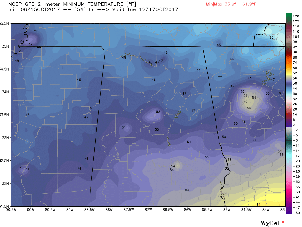
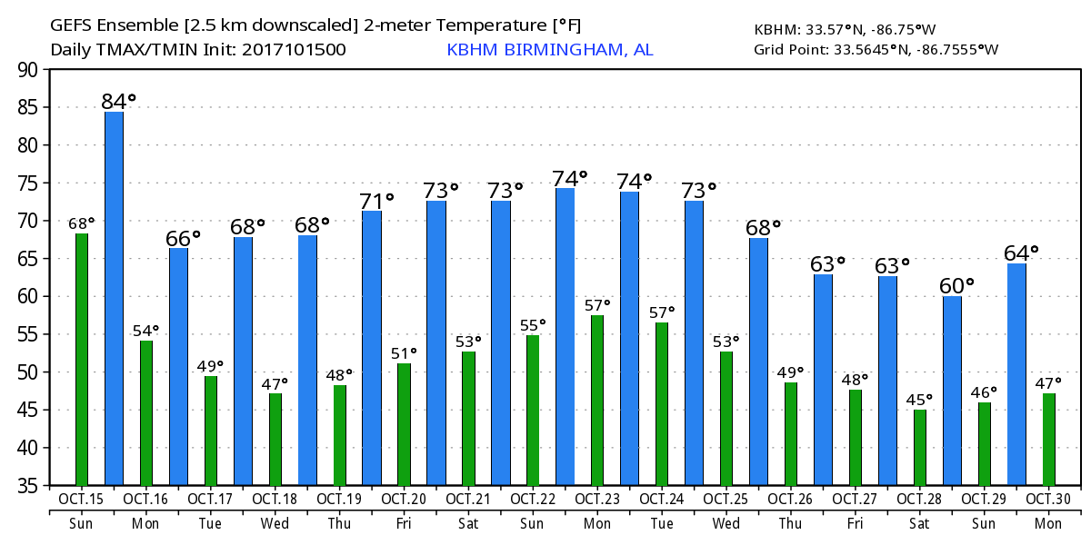
By Monday at midday the cold front is moving out of Alabama, and the upper flow over the Southeast US goes northwesterly bringing cool, dry air into the Southeast US. The surface high will settle into the Ohio River Valley by Tuesday setting the stage for what could be the coolest mornings so far this Fall season with morning lows Tuesday and Wednesday in the 40s. Daytime highs Monday, Tuesday, and Wednesday are expected to be in the lower 70s. That will feel a little cooler with the dew points in the middle 40s.
The latter part of the week will feature the development of an upper ridge over the Southeast US building northward across a chunk of the eastern US. The surface high will be situated just to our north over the Ohio River Valley. This sets the stage for morning lows around the 50 to 52 degree mark with afternoon highs in the upper 70s. Together with the continuation of low dew points, it should feel absolutely great.
VOODOO COUNTRY
The overall pattern into next weekend looks like it will keep us dry with temperatures pretty close or just slightly above seasonal values. A strong upper trough is forecast to bring a surface front into the Lower Mississippi River Valley Sunday, so it looks like we could see a pretty good shot at some rain Monday as we move into voodoo country. That front should produce another round of cool weather around the 24th. An upper ridge promises to bring temperatures back up around the 26th, and then look out Nellie! The GFS is projecting a really strong upper trough to dig into the East Coast around the 28th of October and that pattern looks very chilly with a northwesterly flow coming into the Southeast US straight out of western Canada. If that pattern verifies, we could be looking at the first freeze for Fall 2017. But it is voodoo country, so we’ll see how this evolves. But if you don’t like cold weather, not to worry. An upper ridge is forecast to build into the area around the 30th of October helping to bring temperatures back up.
I had a great time serving as one of the chili cook-off judges at the Cheaha State Park Chill-O-Ween. There was a remarkable crowd there for the event, and the chili was just great. There were 10 different chili styles for everyone to sample. That was my first opportunity to be a chili judge and I hope I get another shot at it. Plus Cheaha State Park is an awesome place to visit even if you have no reason at all. James Spann will be back with the next Weather Xtreme Video bright and early on Monday morning. Enjoy this last really warm day for a while. Godspeed.
-Brian-
Category: Alabama's Weather, ALL POSTS
About the Author (Author Profile)
Brian Peters is one of the television meteorologists at ABC3340 in Birmingham and a retired NWS Warning Coordination Meteorologist. He handles the weekend Weather Xtreme Videos and forecast discussion and is the Webmaster for the popular WeatherBrains podcast.Subscribe
If you enjoyed this article, subscribe to receive more just like it.


