Widespread Frost Tonight, Above Normal Temperatures, Showers By End of the Week
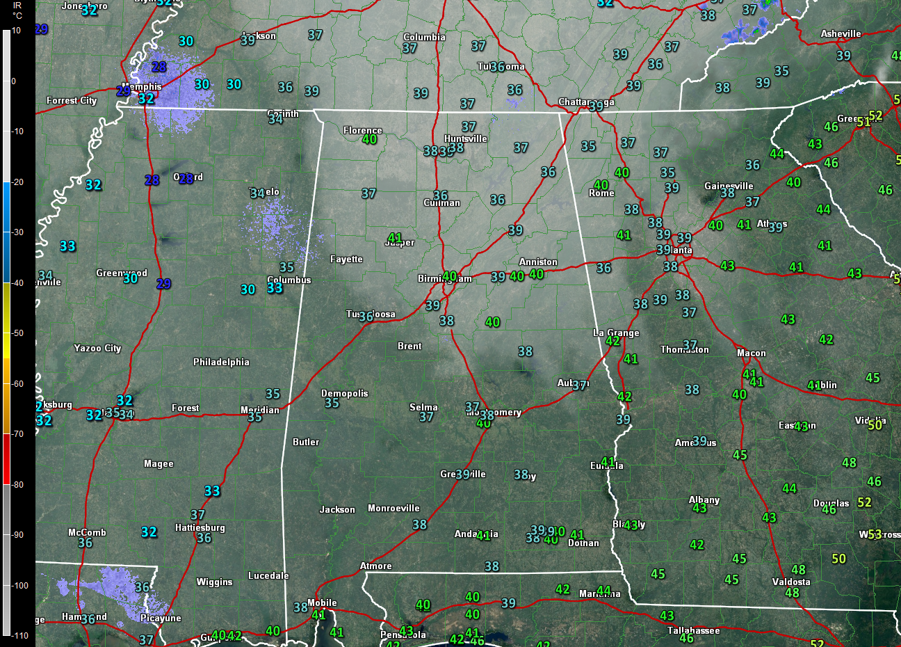
Good morning! We’re off to a chilly start this morning, with lows in the lower and middle 30s across much of the area. There is some frost, especially over western sections of the state, where skies cleared earlier and winds calmed a bit. One more frosty night is in store before moderation sets in for the early part of the week.
Here are 5 a.m. temperatures overlaid on a visible satellite image:
Let’s dig into the details.
ON THE WEATHER MAPS: We find the axis of a deep upper-level trough extending from near South Bend, Indiana to near Anniston, Alabama. This trough is becoming negatively tilted as it rotates northeastward. This system will spin up a powerful extratropical low over eastern North Carolina that will pound the northeast with wind and rain, aided by the moisture from Tropical Storm Phillippe, which it will absorb by Monday. Our upper flow will go from northwesterly today to more westerly tonight and Monday. This will allow temperatures to moderate. A disturbance will approach in this flow by Wednesday but will be stymied by an upper level high to our east that will flex its muscles. As that high weakens over the weekend, another trough will have a shot to bring more showers. Let’s go day by day.
TODAY: Sunny but cool. Highs in the 50s. Tonight will feature upper 30s to near 40F over West Alabama with lower and middle 30s for areas east of I-65. Frost advisories will likely be required for tonight and early Monday for areas east of I-65.
MONDAY MODERATION: Highs on Monday will reach into the middle 60s again with near total sunshine. Monday night lows will be in the lower and middle 40s.
TUESDAY – FLIRTING WITH 70F: The ol’ thermometer will be flirting with 70F by Tuesday afternoon, after morning lows in the 40s. Skies should be partly cloudy.
WEDNESDAY/THURSDAY WARMTH: That approaching upper level and surface frontal system will try to trigger a few showers by late Wednesday into Thursday. Highs both days will be in the middle 70s. Lows will be near 60F.
SHOWERS ROUND TWO: That flexing high-pressure system to our east will beat down the approaching system Wednesday, but it should weaken enough to allow another system to produce showers and a few storms late Frida y into Saturday. The good news is that the showers look like they will be diminishing in time for the Alabama/LSU contest in Tuscaloosa Saturday evening. Things look better earlier in the day at Auburn travels to College State to take on Texas A&M in a late morning tilt. Sunday look like it will be mainly dry and mild.
VOODOOLAND: It looks like glancing storm system will bring chances of shows and storms on the 7th and the 11th.
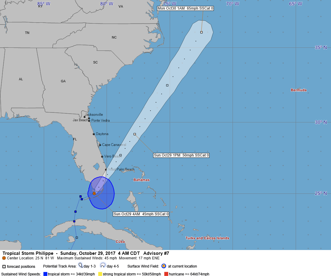
ALL ABOU PHILIPPE: The system over the western Caribbean finally got its act together on Saturday and became Tropical Storm Philippe. It is accelerating northeastward this morning and is already north of the Bahamas and east of Vero Beach. It still was disorganized overnight but strengthened even as it was crossing South Florida. All this despite increasing wind shear and dry air that the storm was battling. Winds spreading apart and accelerating up in the upper levels allowed the intensification to happen. Tropical Storm Warnings were in effect for the marine waters along the Keys and Southeast Florida with a Tropical Storm Watch for coastal locations. Top winds are 50 mph now.
But the big story is the low that is forming over eastern North Carolina. This low will strengthen rapidly as it tracks up the East Coast. It will also entrain a lot of the moisture from Phillippe starting tonight and Monday. This will produce some very heavy rainfall amounts over New England, where flash flood watches are in effect. The strong low-pressure system will produce strong winds from New York to Boston as well. In the Big Apple, winds of 25-35 mph with gusts to 55 mph have prompted a high wind watch. Boston is expecting wind gusts to 65 mph, and high wind warnings cover much of New England.
GULF COAST WEATHER: Dry and cool today along the beautiful beaches of Alabama and Northwest Florida. Highs today will be in the lower 60s. It’s back to the lowe r70s tomorrow and 70s will be the rule through Friday. A few 80-degree readings will show up by the weekend. Showers will be few and far between all week, and most likely by Saturday and the weekend. The water temperature at Pensacola this morning was 69.1F. The rip current risk is moderate today, but things will be smoothing out a bit by tomorrow through the rest of the week.
Click here to see the Beach Forecast Center page. Save Up To 25% on fabulous Fall Beach Vacations on the Alabama Gulf Coast with Brett/Robinson! The Beach Forecast is partially underwritten by the support of Brett/Robinson Vacation Rentals in Gulf Shores and Orange Beach. Click here to see Brett/Robinson’s best beach offers now!.
WEATHERBRAINS: This week, the panel will entertain newly minted Ph.D. Meteorologist Josh Eachus from WBRZ-TV in Baton Rouge, LA. He is a self-proclaimed Communications Nerd and we will be talking about social media and meteorology. Check out the show at www.WeatherBrains.com. You can also subscribe on iTunes. You can watch the show live at live.bigbrainsmedia.com. You will be able to see the show on the James Spann 24×7 weather channel on cable or directly over the air on the dot 2 feed.
ON THIS DATE IN 2012: The center of Superstorm Sandy made landfall at 7:30 p.m. EDT near Brigantine NJ. The storm was over 1,300 miles wide, cost $85 billion in damage, killed at least 192 people and destroyed at least 650,000 homes. 8.5 million people were without power from South Carolina to Maine to Ohio. Follow my weather history tweets on Twitter. I am @wxhistorian at Twitter.com.
Category: Alabama's Weather, ALL POSTS
About the Author (Author Profile)
Bill Murray is the President of The Weather Factory. He is the site's official weather historian and a weekend forecaster. He also anchors the site's severe weather coverage. Bill Murray is the proud holder of National Weather Association Digital Seal #0001 @wxhistorianSubscribe
If you enjoyed this article, subscribe to receive more just like it.


