Pleasant Days, Cool Nights
FOGGY START: We have a Dense Fog Advisory up this morning for parts of Central and East Alabama, visibility is down to under a quarter of a mile in spots. Once the fog dissipates, the day should be sunny with a high in the mid 60s this afternoon.
REST OF THE WEEK: Look for mostly sunny, pleasant days and clear, cool nights through Friday. Highs mostly in the 60s, lows mostly in the 40s. Colder spots will visit the 30s early tomorrow and Wednesday morning. Some scattered clouds will develop Friday, but we still should see a good deal of sunshine.
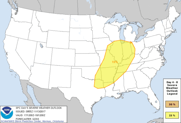
TO THE NORTHWEST OF ALABAMA: We note SPC has defined a severe weather risk on Friday (Day 5) from Northeast Texas up to near Chicago and Indianapolis ahead of a vigorous low that will move into the Great Lakes region Saturday… the “witch of November”…
THE ALABAMA WEEKEND: A cold front trailing the Great Lakes low will pass through the state Saturday, and will bring a chance of rain and storms to our state as the weekend begins. A few strong storms will be possible along the front; the main issue will come from straight line thunderstorm winds mainly over the northern third of the state, where dynamic forcing will be stronger.
Timing of the rain Saturday is uncertain. The American global model (the GFS) hints the best chance of rain and storms will come during the morning hours, while the European model (the ECMWF) is slower, with storms most likely during the afternoon. One way or another, it won’t rain all day, just if you have something planned outdoors just be ready for some rain at times, and possibly a strong thunderstorm.
Sunday looks sunny and very cool with a high in the 48-52 degree range; we will be close to freezing early Sunday morning.
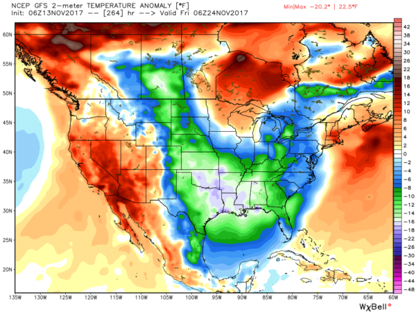
NEXT WEEK: The week starts will chilly weather; a widespread freeze is very possible early Monday. Then, later in the week, global models show the coldest air so far this season moving in here by Thanksgiving Day and Black Friday with potential for highs in the 40s and lows in the 20s. Cold air likely hangs around for the Iron Bowl on Saturday November 25, but too early for a specific forecast, of course. See the Weather Xtreme video for maps, graphics, and more details.
TROPICS: A disturbance over the eastern Atlantic has a medium chance of developing over the next five days… no threat to North America. The rest of the Atlantic basin is quiet.
BEACH FORECAST: Click here to see the AlabamaWx Beach Forecast Center page. The Beach Forecast is partially underwritten by the support of Brett/Robinson Vacation Rentals in Gulf Shores and Orange Beach. Click here to see Brett/Robinson’s Hot Deals now!
WEATHER BRAINS: Don’t forget you can listen to our weekly 90 minute netcast anytime on the web, or on iTunes. This is the show all about weather featuring many familiar voices, including our meteorologists here at ABC 33/40. We will produce this week’s show tonight at 8:30 CT… you can watch it live here.
CONNECT: You can find me on all of the major social networks…
Facebook
Twitter
Google Plus
Instagram
Pinterest
Snapchat: spannwx
I have a weather program this morning at West Elementary in Vestavia Hills… look for the next Weather Xtreme video here by 4:00 this afternoon. Enjoy the day!
Category: Alabama's Weather, ALL POSTS, Weather Xtreme Videos
About the Author (Author Profile)
James Spann is one of the most recognized and trusted television meteorologists in the industry. He holds the AMS CCM designation and television seals from the AMS and NWA. He is a past winner of the Broadcast Meteorologist of the Year from both professional organizations.Subscribe
If you enjoyed this article, subscribe to receive more just like it.


