Rain Chances Afternoon and Evening Then Dry
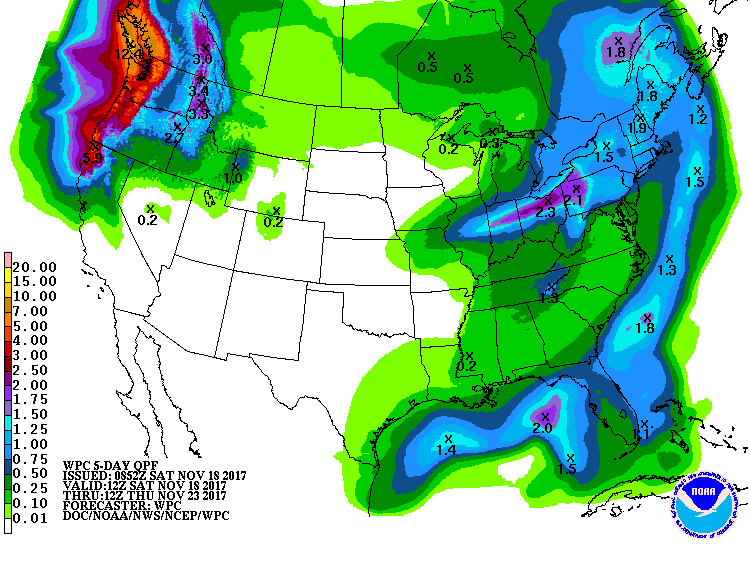
The sky across the northern half of Alabama was mostly cloudy with sunrise while the southern portion of the state was partly cloudy. Temperatures were mainly in the 40s in East Alabama and in the 50s across West Alabama while it was quite a bit warmer across Mississippi where readings were in the 60s. Temperatures showed the significant warm air advection taking place just to our west ahead of the surface front. A low pressure storm system was located in the vicinity of St. Louis this morning with a cold front trailing southwestward into West Texas. A nice upper trough over the Central Plains was poised to move across the eastern half of the country later today and into the first half of Sunday bringing some meager rain chances to Central Alabama. Moisture remained somewhat limited keeping rain chances in check and holding rainfall totals to less than a quarter of an inch for those who do see showers. It should be fairly warm today with most locations seeing at least the mid and upper 60s and some locations from Birmingham southward could see a high of 69 to 72.
Football Weather: Alabama hosts the Mercer Bears at Bryant-Denny Stadium with an 11 am CST kickoff. The sky will be cloudy and a shower is possible by the fourth quarter, but the best chance of showers in Tuscaloosa should come after 3:00 pm. Temperatures will be in the upper 60s at kickoff rising to near 72 by the second half. Auburn will host Louisiana-Monroe Saturday at Jordan-Hare Stadium also with an 11 am CDT kickoff. It will be mostly cloudy but dry; best chance of rain in Auburn comes after 6:00 pm. Temperatures will be in the 65-70 degree range. And UAB will be down in Gainesville at The Swamp to take on the Florida Gators with a 3 pm CST kickoff. The weather will be be mostly sunny with a kickoff temperature near 80 degrees at kickoff dropping back into the mid 70s by the second half.
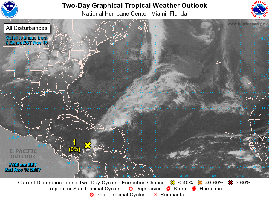
Tropics: A disturbance over the far southern Caribbean has a low chance of development over the next five days. Elsewhere the Atlantic basin is quiet.
Beach Forecast: Click here to see the AlabamaWx Beach Forecast Center page. The Beach Forecast is partially underwritten by the support of Brett/Robinson Vacation Rentals in Gulf Shores and Orange Beach. Click here to see Brett/Robinson’s Hot Deals now!
SPC has a small area outlined for the standard slight risk of severe storms centered mainly on western Kentucky for Day 1. The marginal risk area just clips the Northwest and North Central parts of Alabama. Days 2 and 3 go very quiet.

The front blasts quickly through Alabama this evening and early Sunday along with the upper trough so that by daybreak Sunday the front should be exiting the state taking any rain chances with it. The strong northwesterly flow and cold air advection will drop highs back into the 50s for Sunday and again Monday.
Monday we see the upper air pattern go briefly into a ridge so Monday will be warmer by several degrees than Sunday. Monday morning we should see widespread temperatures in the lower 30s across North and Central Alabama as the surface high settles in over the Southeast US and our wind goes calm for Monday morning providing good radiational cooling conditions. I think there will be some widespread frost, but the air will be very dry with dew points into the lower and middle 20s.
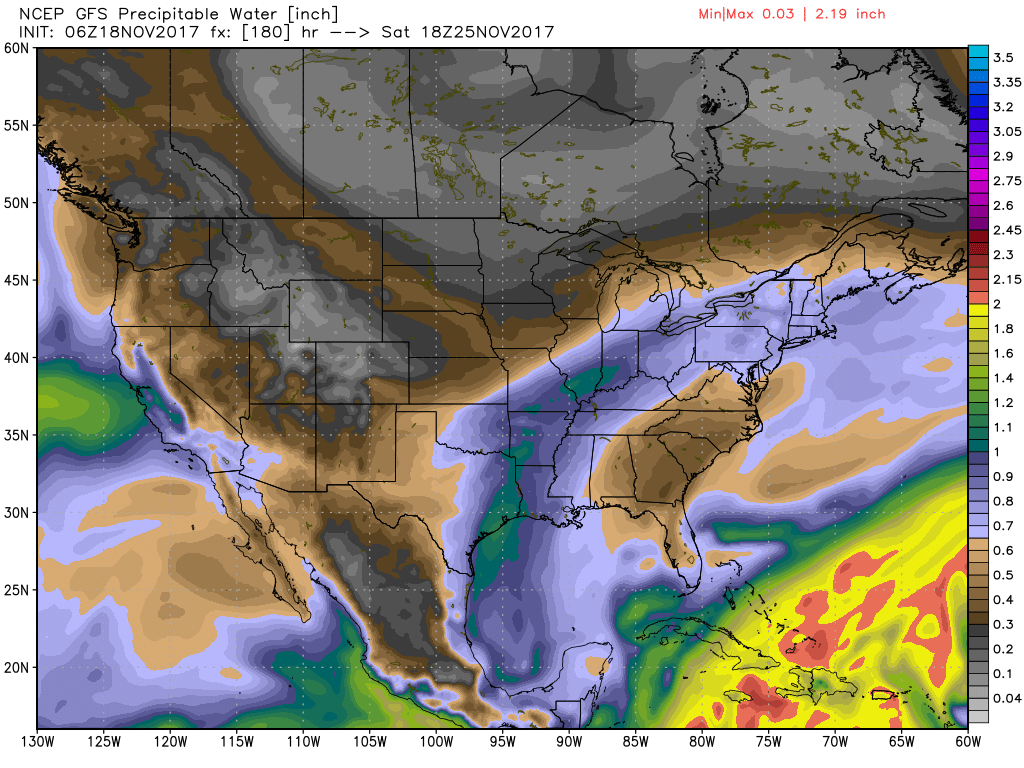
For the rest of the week into Thanksgiving and Black Friday, we see another deep trough migrate into the Southeast from the northwest, so we should stay mild but dry. As you can see from the precipitable water chart below for Wednesday, the atmosphere is forecast to remain very dry over nearly all of the United States. Tuesday and Wednesday we should see highs in the 60s with lows around 40, values pretty close to what you would expect for the middle to latter part of November.
The strong upper trough and closed low moves off the Southeast US coast on Thanksgiving Day, so the weather should be dry but chilly with highs Thanksgiving day only in the 50s. A new short wave coming across the Central Plains on Saturday will probably bring some clouds, however, precipitable water values remain quite low so it looks like Black Friday along with next weekend will remain dry even if a front manages to make it into the Southeast by next Sunday. Highs should be in the 50s along with lows in the 30s for Friday and the weekend.
Looking into voodoo country, the pattern remains fast with a series of upper troughs. One digs into the East on November 27th, but by the 29th we’re under a nice ridge that suggests a nice warm up by the 29th and 30th. Another trough glances by well to our north around December 1st, and then a strong trough comes out of the Rockies around the 3rd. Keep in mind that our Fall severe weather season typically stretches into the first couple of weeks of December, so we are not necessarily out of the woods just yet.
WEATHER BRAINS: Don’t forget you can listen to our weekly 90 minute netcast anytime on the web, or on iTunes. This is the show all about weather featuring many familiar voices, including our meteorologists here at ABC 33/40.
Look for my next Weather Xtreme Video here Sunday morning by 7:00 or so. Enjoy the weekend and Godspeed.
-Brian-
Category: Alabama's Weather, ALL POSTS
About the Author (Author Profile)
Brian Peters is one of the television meteorologists at ABC3340 in Birmingham and a retired NWS Warning Coordination Meteorologist. He handles the weekend Weather Xtreme Videos and forecast discussion and is the Webmaster for the popular WeatherBrains podcast.Subscribe
If you enjoyed this article, subscribe to receive more just like it.


