Freeze Warning for Monday Morning
I think I used the right word yesterday when I mentioned that the cold front would “blast” through Alabama. It certainly lived up to that description as it came through the state yesterday afternoon and evening with a few severe thunderstorm warnings posted in the Tennessee River Valley and north. You can see from the temperature trace at my station in Helena exactly when the rain and the front came by.
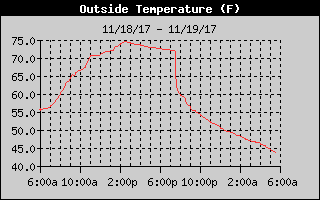
The satellite view of the Southeast US this morning showed a large area of clear skies, but there were still large areas of low clouds across the eastern half of Alabama and into Georgia. The sky should continue to clearing for those areas with clouds with the area sunny by late morning. But what a difference a day makes in temperature. The afternoon highs today should be only in the 50s, about 20 degrees colder than the middle 70s we saw yesterday. The wind won’t be quite as strong as yesterday, but for the morning and early afternoon the wind will be in the 10 to 20 mph range out of the northwest.
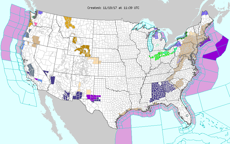
The surface high over Texas this morning settles into the Southeast US tonight and early Monday paving the way for good radiational cooling along with the cold air advection. The result is that freeze warnings have been posted for late tonight into early Monday morning for nearly all of Alabama with the exception of a row of counties along the Florida border.
The weather for the week ahead including Thanksgiving is expected to be dry. The front that blasted through last night is going to leave very dry air in its wake, and little in the way of moisture return is forecast to occur over the next several days. The upper trough that brought the front will move off the Atlantic Coast as it is replaced by an upper ridge briefly on Monday. So we should see our afternoon highs on Monday return to near 60.
Another short wave digs into the northern Gulf of Mexico on Tuesday, Wednesday, and Thursday, so this returns our flow aloft to the northwest keeping temperatures capped in the lower 60s at best. This pattern also remains dry without a good moisture return, so we stay dry into Thanksgiving. After the widespread freezing temperatures on Monday, we should warm enough with lows through midweek in the upper 30s.
The trough over the Southeast US on Thanksgiving moves eastward into the Atlantic for Black Friday and into the weekend. This maintains the dry and cool northwesterly flow into the weekend. Highs Friday and Saturday will reach the lower 60s with lows in the lower 40s. A weak short wave aloft Sunday will reinforce the cold air dropping afternoon highs back into the 50s.
Tropics: A disturbance over the far southern Caribbean has a low chance of development over the next five days. Elsewhere the Atlantic basin is quiet.
Beach Forecast: Click here to see the AlabamaWx Beach Forecast Center page. The Beach Forecast is partially underwritten by the support of Brett/Robinson Vacation Rentals in Gulf Shores and Orange Beach. Click here to see Brett/Robinson’s Hot Deals now!
Looking further into the future, the pattern for voodoo country stays fairly active. The GFS is pumping up a nice ridge over the eastern US around the 29th of November which should spell some really warm temperatures for late November. I dare say we might see values reaching the lower 70s. A short wave in Canada and the Great Lakes will dampen the ridge somewhat around the 2nd of December. But the look of the upper air pattern is rather scary for the 4th of December with a pattern that strongly suggests the potential for a significant round of severe weather. This is voodoo country, so we’re not making a specific forecast right now. I’m just saying that if this pattern verifies, it is definitely suggestive of big round of severe weather. We’ll continue to watch this, but we know this far out in voodoo country, changes will occur and the whole feature may be gone in the next model run.
I forgot to mention yesterday that I had a great time doing a severe storm spotter training session for the Bald Rock Amateur Radio Club in Pell City. A big thanks goes to Mike Shaw for arranging everything, and we had a nice turnout. You can expect to see the next Weather Xtreme Video posted here by James Spann first thing on Monday morning. It will be quite cold Monday morning, so if your vehicle is parked outside, you may need a little extra time to get your windshield clear for driving. Have a great day and Godspeed.
-Brian-
Category: Alabama's Weather, ALL POSTS
About the Author (Author Profile)
Brian Peters is one of the television meteorologists at ABC3340 in Birmingham and a retired NWS Warning Coordination Meteorologist. He handles the weekend Weather Xtreme Videos and forecast discussion and is the Webmaster for the popular WeatherBrains podcast.Subscribe
If you enjoyed this article, subscribe to receive more just like it.


