Showers Return To Alabama Thursday
BLUE SKY AND SUNSHINE: Temperatures are in the 67-70 degree range across North/Central Alabama this afternoon with hardly a cloud in the sky. Tonight will be mostly fair and not as cold as recent nights; most places will see a low in the 40s early tomorrow.
TOMORROW/THURSDAY: The weather remains dry tomorrow, but we will see a general increase in clouds as a short wave approaches from the west. The weather will stay mild with a high not too far from 70 degrees, almost ten degrees above average for the end of November. Then, on Thursday, we will mention a chance of showers as a surface front moves in. Moisture will be rather limited, and we project rain amounts to be a quarter of an inch or less for most communities. The high Thursday will be in the mid to upper 60s with a mostly cloudy sky.
FRIDAY THROUGH THE WEEKEND: The sky becomes partly sunny Friday; the high will be in the 65-69 degree range. Then, over the weekend, the weather stays dry with with pleasant afternoons and cool nights. The high Saturday will be in the upper 60s, then dropping into the mid 60s Sunday. Lows over the weekend will be mostly in the 40s.
FOOTBALL WEATHER: For the high school playoff games Friday evening, the sky will be mostly fair with temperatures falling through the 50s.
For Auburn fans headed to Atlanta and the SEC Championship game Saturday against Georgia (3p CT kickoff)… no weather worries, of course, inside Mercedes-Benz Stadium, but for those walking to the game the sky will be mostly cloudy with just a small chance of a shower; afternoon temperatures should be in the 60s.
Jacksonville State hosts the Kennesaw State Owls Saturday at Burgess–Snow Field (1p CT kickoff)… the sky will be partly sunny with temperatures in the 60s during the game.
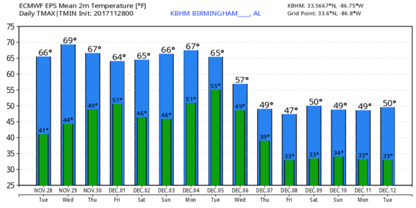
NEXT WEEK: After a cold start early Monday with morning lows near freezing, we rise into the 60s Monday afternoon with a sunny sky. Global models are in better agreement now concerning the pattern change; we will have a good chance of rain and possible thunderstorms Wednesday night into Thursday, followed by sharply colder air Friday. For now the severe weather threat looks low; rain amounts should be in the 1/2 to 1 inch range. By Friday (December 8) highs will drop into the 40s for the northern half of Alabama.
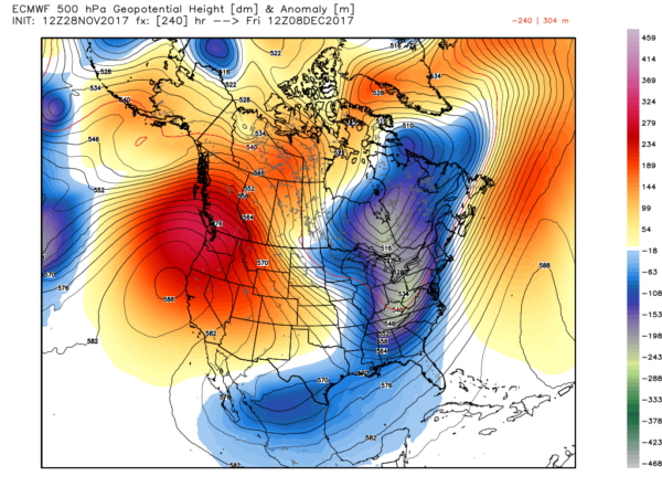
Looks like temperatures will remain below average through mid-December as a blocked upper air pattern keeps an upper trough over the eastern third of the U.S. See the Weather Xtreme video for maps, graphics, and more details.
BEACH FORECAST: Click here to see the AlabamaWx Beach Forecast Center page. The Beach Forecast is partially underwritten by the support of Brett/Robinson Vacation Rentals in Gulf Shores and Orange Beach. Click here to see Brett/Robinson’s Hot Deals now!
WEATHER BRAINS: Don’t forget you can listen to our weekly 90 minute netcast anytime on the web, or on iTunes. This is the show all about weather featuring many familiar voices, including our meteorologists here at ABC 33/40.
CONNECT: You can find me on all of the major social networks…
Facebook
Twitter
Google Plus
Instagram
Pinterest
Snapchat: spannwx
Look for the next Weather Xtreme video here by 7:00 a.m. tomorrow…
Category: Alabama's Weather, ALL POSTS, Weather Xtreme Videos
About the Author (Author Profile)
James Spann is one of the most recognized and trusted television meteorologists in the industry. He holds the AMS CCM designation and television seals from the AMS and NWA. He is a past winner of the Broadcast Meteorologist of the Year from both professional organizations.Subscribe
If you enjoyed this article, subscribe to receive more just like it.


