

Nice Weekend, Colder by End of Week
If you are a fan of the milder weather that we’ve been experiencing, be sure to take advantage of the next several days. Model projections continued to point to a major pattern shift with a deep trough over the eastern US which will spell much colder weather for the entire eastern US.
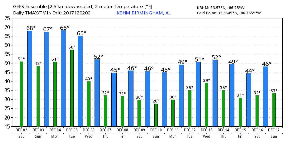
This morning we continue to be plagued with dense fog with dense fog advisories for a big section off the southern US from coastal Texas to Georgia. The fog is not likely to burn off to reveal a clear sky, but instead gradually lift into a cloud layer. There will probably be some thin spots in the clouds where we could see of peeks at the sun. Temperature forecasts are a little tricky. I believe it will be mild, but I’m afraid the cloud deck will limit the upward extent of temperatures with highs mainly to the middle 60s. Where we do get some significant breaks in the clouds, highs could rise to near 70. Even the middle 60s would be about 5 degrees above our seasonal average.

Football Weather: For Auburn fans headed to Atlanta and the SEC Championship game this afternoon against Georgia with a 3 pm CST kickoff, there are no weather worries, of course, inside Mercedes-Benz Stadium, but for those walking to the game the sky will be partly sunny; afternoon temperatures should be in the 60s. And Jacksonville State hosts the Kennesaw State Owls today at Burgess–Snow Field with a 1 pm CST kickoff where the sky will be mostly cloudy with temperatures in the middle 60s during the game.
Fog will become a problem once again tonight and into the first part of Sunday morning. I suspect we’ll see another dense fog advisory for much of the southern two-thirds of Alabama. With a ridge aloft and high pressure centered over Ohio, there is just no push to get this moisture out of the area. Highs Sunday will once again vary depending on just how much sun a spot gets with highs in the range of 65 to 70, still mild for early December.
Monday we begin to take note of the strong upper trough coming out of the northern Rockies. The upper trough generates a surface low over the northern Rockies on Sunday that moves out into Minnesota on Monday as a surface front trails to the southwest into Oklahoma and North Texas. Moisture is forecast to surge northward ahead of the front in the strong southerly flow Monday and Tuesday. Precipitable water levels are forecast to reach the range of 1.2 to 1.4 inches, sufficient for some better rains but somewhat shy for any real threat of severe storms. SPC has an area of thunderstorms outlooks ahead of the front on Monday, Day 3. Monday remains mild with highs likely to reach the lower 70s.
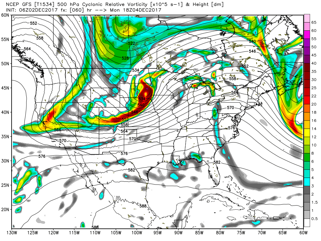
Tuesday the upper trough really digs into the eastern US producing a broad trough over the East by Wednesday. The surface low moves quickly into eastern Canada by Wednesday with the cold front project to move through Alabama Tuesday afternoon and during the first half of Wednesday. By 18Z Wednesday the front should be located along the Gulf Coast. Highs Tuesday will be largely dependent on the exact timing of frontal passage at your location. Highs may occur in some locations early in the day Tuesday. Wednesday may be a somewhat raw day for much of Alabama as temperatures struggle to reach the lower 50s. We should see some improvement in the sky cover Wednesday with sunshine returning during the latter part of the day.
From Thursday through Saturday, the pattern is going to remain somewhat unchanged with the trough firmly established in place over the eastern US. This will allow a series of short wave troughs to rotate through the larger trough helping to reinforce the cold air. Highs during this period will stick in the 50s with morning lows getting into the upper 20s and lower 30s. Each of the short waves troughs may bring some clouds with them, but overall precipitable water values will remain quite low, below a half inch.
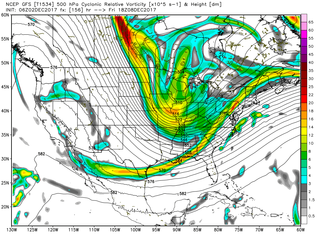
Looking out into voodoo country, the upper trough over the eastern US remains stuck in place until around the 15th of December. From the 16th through the 17th, the pattern begins another big shift as the upper trough migrates into the Atlantic as it is replace by a strong upper ridge. This pattern promises to bring some warmer weather back to the eastern US for the middle of December.
Beach Forecast: Click here to see the AlabamaWx Beach Forecast Center page. The Beach Forecast is partially underwritten by the support of Brett/Robinson Vacation Rentals in Gulf Shores and Orange Beach. Click here to see Brett/Robinson’s Hot Deals now!
WEATHER BRAINS: Don’t forget you can listen to our weekly 90 minute netcast anytime on the web, or on iTunes. This is the show all about weather featuring many familiar voices, including our meteorologists here at ABC 33/40.
Thanks so much for tuning into the Alabama Weather Blog. I’m excited to be emceeing the Helena Christmas Parade once again this year. The parade kicks off at 1 pm and runs from the Publix/Walmart intersection northward along 261 into Old Town Helena. While the sky may be cloudy, temperatures will be mild some come on out for a great parade. This evening and Sunday I will be filling in for Charles Daniel on the news on ABC 3340, so tune in for the latest updated forecast. I plan to have the next Weather Extreme Video posted by 7 or so on Sunday morning. Have a great day and Godspeed.
-Brian-
Category: Alabama's Weather, ALL POSTS
About the Author (Author Profile)
Brian Peters is one of the television meteorologists at ABC3340 in Birmingham and a retired NWS Warning Coordination Meteorologist. He handles the weekend Weather Xtreme Videos and forecast discussion and is the Webmaster for the popular WeatherBrains podcast.Subscribe
If you enjoyed this article, subscribe to receive more just like it.


