Mild Temperatures This Week; Wet/Stormy At Times
SOME SUN: We have some breaks in the cloud cover over the northern third of our state this afternoon… most of the showers are over the southern counties, and very scattered in nature. Temperatures have reached the 60 degree mark across North/Central Alabama. Clouds thicken tonight, and showers remain isolated.
TOMORROW/WEDNESDAY: An upper low is lifting out of the Southwest U.S., and will bring a big rain event to parts of the southern U.S. over the next few days. Here in Alabama, most of the rain will come tomorrow afternoon, tomorrow night, and into at least part of the day Wednesday. The rain could be heavy at times over the northern third of the state, where 48 hour totals could be in the 3-4″ inch range… places like Birmingham, Tuscaloosa, Anniston, and Gadsden should see 1-2″.
The air will become unstable late tomorrow night and into Wednesday, and a few strong to severe thunderstorms are possible. SPC has a “marginal risk” of severe storms defined for the I-20/59 corridor..
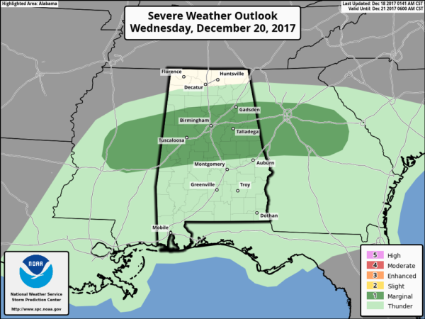
Seems like the main risk of severe storms will come from 3:00 a.m. until 3:00 p.m. Wednesday; the primary threat will come from gusty straight line winds, but forecast helicity values suggest an isolated tornado or two will be possible. We will watch radar trends closely.
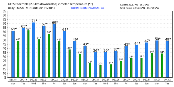
Temperatures will be mild; we reach the mid 60s tomorrow, and then Wednesday’s high will be close to 70 degrees.
THURSDAY/FRIDAY: Thursday for now looks dry and mild; with a mix of sun and clouds the high will be at or just over 70 degrees. Clouds thicken Thursday night, and rain moves back into the state Friday ahead of a cold front. Some thunder is possible, but for now severe storms are not expected.
THE ALABAMA WEEKEND: Forecast confidence drops dramatically over the weekend as models diverge in their solutions in a complex pattern. The GFS (American model) suggests Saturday will be dry and colder, followed by a chance of rain again Sunday or Sunday night as a wave of low pressure forms along the front. We will trend the forecast toward this solution, but the European model (ECMWF) holds the front off until Sunday and suggests a chance of rain both days with mild temperatures.
We will forecast highs in the 50s over the weekend for now, but understand it could be warmer or colder, depending on the placement of the Arctic front.
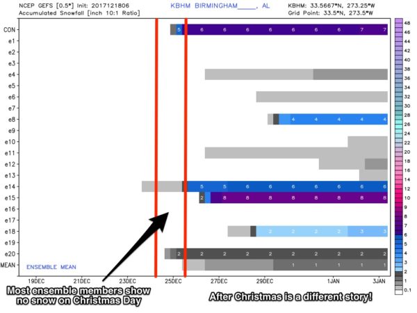
CHRISTMAS DAY: The forecast doesn’t get any easier. Both global models suggest a wave forms on the Arctic front with some chance of precipitation, which is in stark contrast to the dry look they gave just 12 hours ago. We will introduce for now a chance of rain on Christmas Day, with potential for some “wintry precipitation” on the northern periphery across the northern third of the state. We stress this is a low confidence forecast, and it will change in coming days.
While the precipitation forecast is very iffy, we are growing in confidence that Christmas Day will be cold. Some places across North Alabama could hold below freezing all day as Arctic air settles into our state.
In fact, all of next week looks very cold, and ensemble model output hints at potential for winter mischief perhaps in the cold air during the mid-week period. Just too early to know.
We need to get through the mid-week rain/storm event, and we will have a much better look at the Christmas weather situation Thursday and Friday. Take some time to watch the Weather Xtreme video for maps, graphics, and more details.
BEACH FORECAST: Click here to see the AlabamaWx Beach Forecast Center page. The Beach Forecast is partially underwritten by the support of Brett/Robinson Vacation Rentals in Gulf Shores and Orange Beach. Click here to see Brett/Robinson’s Hot Deals now!
WEATHER BRAINS: Don’t forget you can listen to our weekly 90 minute netcast anytime on the web, or on iTunes. This is the show all about weather featuring many familiar voices, including our meteorologists here at ABC 33/40.
CONNECT: You can find me on all of the major social networks…
Facebook
Twitter
Google Plus
Instagram
Pinterest
Snapchat: spannwx
I enjoyed seeing the 6th graders today at Mountain Brook Elementary School… be looking for them on the Pepsi KIDCAM today at 5:00 on ABC 33/40 News! The next Weather Xtreme video will be posted here by 7:00 a.m. tomorrow…
Category: Alabama's Weather, ALL POSTS, Weather Xtreme Videos
About the Author (Author Profile)
James Spann is one of the most recognized and trusted television meteorologists in the industry. He holds the AMS CCM designation and television seals from the AMS and NWA. He is a past winner of the Broadcast Meteorologist of the Year from both professional organizations.Subscribe
If you enjoyed this article, subscribe to receive more just like it.


