Wind Advisory Issued For the NE Parts of Central Alabama Until 3PM
Strong gradient winds ahead and behind the front will continue through the afternoon in the northeast.
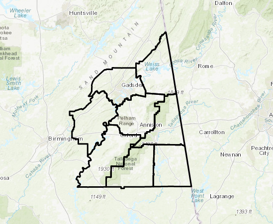
The National Weather Service in Birmingham has issued a Wind Advisory, which is in effect until 3 PM CST this afternoon. The counties in the advisory are Etowah, Calhoun, Cherokee, Cleburne, St. Clair, Talladega, Clay, and Randolph.
TIMING…of the strong winds will continue through 3 pm.
WINDS…of 15 to 25 mph with gust near 35 mph will be possible.
IMPACTS…include difficult driving and downed trees and larger limbs. Unsecured outdoor decorations and patio furniture may also become displaced.
A Wind Advisory means that wind gusts of 35 mph are expected. Winds this strong can make driving difficult…especially for high profile vehicles. Use extra caution.
Category: Alabama's Weather, ALL POSTS
About the Author (Author Profile)
Scott Martin is an operational meteorologist, professional graphic artist, musician, husband, and father. Not only is Scott a member of the National Weather Association, but he is also the Central Alabama Chapter of the NWA president. Scott is also the co-founder of Racecast Weather, which provides forecasts for many racing series across the USA. He also supplies forecasts for the BassMaster Elite Series events including the BassMaster Classic.Subscribe
If you enjoyed this article, subscribe to receive more just like it.


