Cold Definite; Winter Precipitation Still Fuzzy
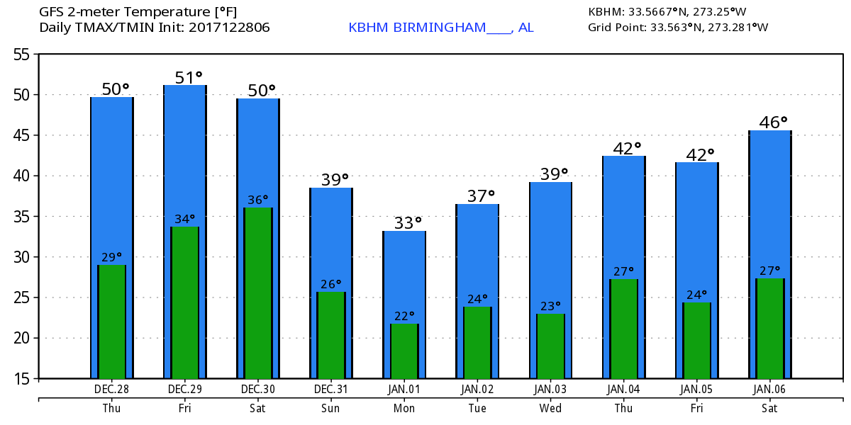
The morning is starting out with low clouds along the Gulf Coast while much of the northern two-thirds of the state is covered by high cirrus clouds. Temperatures are at or below freezing for about the northern 60 percent of Alabama while the southern 40 percent is mainly in the 30s. Mobile is at 39 while Dothan is our warmest spot at 45. It does look like we should see a little warmer day today with highs in the upper 40s, warmer in that it beats the high of 42 yesterday in Birmingham but awfully hard to call 49 degree warm!
The upper air pattern continued to be stuck in the broad trough across the eastern two-thirds of the country. At the surface a strong 1038 millibar high pressure system was moving across the eastern Great Lakes which was setting up a cold air damming, known as CAD or the wedge, for North Georgia. The wedge does not currently appear strong enough to have a serious impact on Alabama weather today or Friday. With the continuation of the upper trough and surface high to our north, we will remain cold and dry Thursday, Friday, and Saturday. Friday and Saturday will likely see our afternoon highs reach the lower 50s. Keep in mind the 30-year average for late December is 54, so we’re going to remain below seasonal averages. Lows do much the same with readings 28 to 33 for those days, again below the seasonal average of 35.
There are two big events on the horizon. The first is the potential for a wintry mix of precipitation with the primary threat mainly for Central and North Alabama. Unfortunately the computer models, mainly the GFS and ECMWF, have not done us well. After being somewhat consistent for several days, the GFS has trended drier. And on the 12Z run yesterday, the ECMWF flipped to an almost identical solution as the GFS. But the latest run of the ECMWF has trended to a much wetter solution that the GFS. So we are still stuck without a solid solution. The two graphics depicting the onset of precipitation from the two models is below.
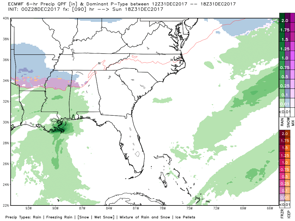
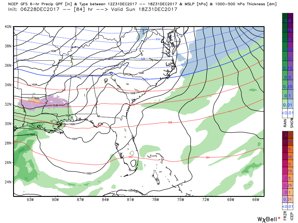
While we may not have a highly confident forecast, we can probably anticipate several elements. There is the potential for wintry precipitation coming primarily on Sunday across the northern half of Alabama. Moisture levels appear low so the wintry precipitation is likely to be light. There is no skill at the moment in determining exact boundaries between liquid and frozen precipitation areas. That will have to wait until we get closer. The main threat area, despite the change in the GFS solution, still appears to be along and north of I-20. Precipitation is forecast to occur mainly Sunday afternoon and evening but could begin as early as Sunday morning especially for West Central and Northwest Alabama. Both models are now ending the precipitation quickly as it moves out rapidly by the first hour of New Year’s Day.
Then comes the second big event – coldest air we’ve seen this season. A strong surface high will be situation across the Central US pumping cold air southward from Canada while the upper air pattern remains in the cold trough that is deepened over the eastern US as the ridge pumps up along the West Coast. This will bring our lows for the first few days of 2018 into the teens with highs for those days struggling to get out of the 30s.
For Wednesday and Thursday, the Arctic grip maintains its hold on the eastern US including Alabama so lows will remain in the teens with highs only in the 30s. This Arctic air has been well forecasted, so people should consider taking precautions for the cold which will be lasting long enough to have significant impacts on items such as exposed pipes.
Looking out into voodoo country, the GFS is suggesting some warmer days around the 9th and 10th of January, but the overall pattern remains quite active with a nearly constant parade of upper air troughs for us to deal with.
Both Auburn and Alabama will be playing inside enclosed stadiums, so there is no worry about the weather during the games. But getting there and home may see some issues. For those headed to Atlanta for the Peach Bowl with Auburn facing the UCF Knights with an 11:45 am CST kickoff, New Year’s Eve will be cold with a high of only 39 along with the potential for rain, snow, and sleet. Game day will also be cold with a high of only 36.
For the Sugar Bowl in New Orleans where Alabama and Clemson face-off at 7:45 pm CST, there will be a chance for rain for New Year’s Eve with a high of 59. New Year’s Day should also see some chance for rain with a high around 41.
Travel on New Year’s Eve could pose some issues for traveling to either game. Due to the light nature of precipitation expected this does not appear to be a significant impact on travel. Keep in mind, we’re still several days out, so the clarity of the precipitation situation should become better as we close in on the event.
Beach Forecast: Click here to see the AlabamaWx Beach Forecast Center page. The Beach Forecast is partially underwritten by the support of Brett/Robinson Vacation Rentals in Gulf Shores and Orange Beach. Click here to see Brett/Robinson’s Hot Deals now!
WeatherBrains: Don’t forget you can listen to our weekly 90 minute netcast anytime on the web, or on iTunes. This is the show all about weather featuring many familiar voices, including our meteorologists here at ABC 33/40.
Thanks so much of tuning into the Weather Xtreme Video. I’m going to be filling in for Meaghan Thomas tomorrow morning on ABC 3340, so Bill Murray will have the hot seat for the video on Friday morning. Enjoy the dry weather for the next several days, and be sure to do what you can to protect your property from the Arctic cold expected for the start of 2018. Godspeed.
-Brian-
Category: Alabama's Weather, ALL POSTS, Weather Xtreme Videos
About the Author (Author Profile)
Brian Peters is one of the television meteorologists at ABC3340 in Birmingham and a retired NWS Warning Coordination Meteorologist. He handles the weekend Weather Xtreme Videos and forecast discussion and is the Webmaster for the popular WeatherBrains podcast.Subscribe
If you enjoyed this article, subscribe to receive more just like it.


