

Winter Weather Advisories Expanded; A Few Things to Look For
The NWS Birmingham has added Clay and Randolph Counties to the Winter Weather Advisory, for the reasons we expunded upon in the Noon Forecast Update on AlabamaWX. Temperatures may well be cold enough for precipitation to begin as freezing rain tonight after midnight in the advisory counties of East Alabama.
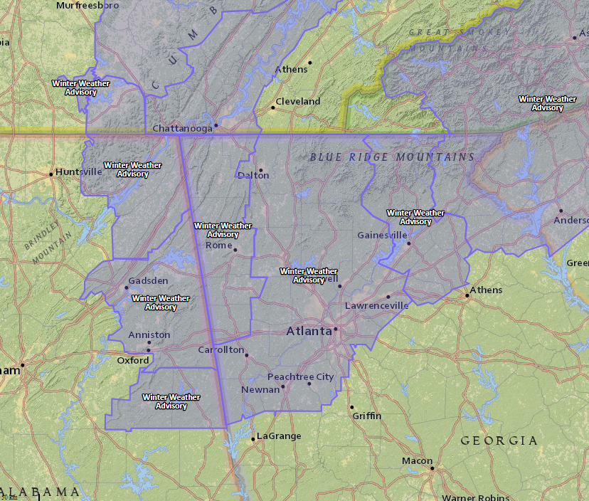
The advisory now includes: Calhoun, Clay, Cleburne, Cherokee and Etowah Counties in Central Alabama and Franklin, DeKalb and Jackson Counties in Northeast Alabama.
The Birmingham counties are in effect until 3 p.m. tomorrow. The Huntsville Counties until 6 p.m. Monday.
From Holly Allen at the NWS Birmingham:
Partners, we added Clay and Randolph counties to the winter weather advisory. Timing remains the same….Midnight thru 9AM Monday. Overall thinking remains the same, as rainfall moves in, some areas in the northeast will be around 32F for a few hours before warmer air arrives. Looking at new temperature guidance, Clay and Randolph now hit 32 for a few hours as rain moves in. Think impacts are the same as before: minor accumulations on mainly elevated surfaces. Two things to watch: how cloud cover moving into the area affects temp trends this evening (it might prevent cooling this evening and we remain too warm for freezing rain) and if the cooler air in the valleys in the northeast is slower to erode early in the morning (monitoring surface obs will be very important).
IMPORTANT FOR ALABAMA FANS HEADING TO ATLANTA
The NWS in Atlanta has also expanded their Winter Weather Advisory to include the northern third of Georgia, including the Atlanta Metro area.
Here is their afternoon discussion on the situation:
…INCREASING CHANCE OF LIGHT FREEZING RAIN FOR A LARGER PORTION OF
NORTH GEORGIA MONDAY MORNING…
A low confidence/potentially high impact winter weather event is the
cause of concern with this update that now looks to involve an
increased chance of light freezing rain potential for a majority of
north GA including the Atlanta metro area for Monday morning.
While some guidance has flip-flopped on amount of actual
precipitation reaching the ground when dealing with a lingering
hybrid CAD wedge at the low levels, there has been enough of some
short term and hi-res solutions that have more widespread
development. There is a pretty robust slug of isentropic upglide
given the Nam 300K theta sfc and while the other upper level forcing
may be breaking off into a southern cutoff and northern impulse, it
is tough to assume the southern extent of this would have much in
robbing moisture (which looks more after 18z before the wave splits).
For sfc temps, have used a blend of some known local hi-res
solutions that better resolve southern wedges along with a few main
solutions. This results in nearly all of north GA at least a few
degrees below freezing starting after midnight. The initial thicker
cirrus deck this afternoon into evening may not help much from how
it’s reduced insolation, and then after the subfreezing values
settle in, the low clouds look to push in from the SW to aid in
wedge reinforcement. Any precip in the morning will be dealing with
dewpts in the single digits to teens initially and some evap cooling
may have further diabatic in-situ reinforcement for the wedge as
well.
As alluded to above,this is basically a low confidence but
potentially very high impact event for our local area given the
number of travelers coming into the local area on Monday. Even a
trace of drizzle given anticipated temps could create quite the
travel headaches through Monday morning. Based on this and the
wetter trends in the short term models, have opted to go winter
weather advisory from Heard through the southern metro and along I
85 to Jackson and Banks. Could see perhaps needing another tier
on the south side of this but will let evening and mid shift have
another look. Will segment advisory based on start and end times
and likely have 3 groups.
Potential exists to have this persist if you believe some short
term guidance (NAM4KWRF) through 18Z and beyond. Temps today with
just thin cirrus have been below forecast which gives some cause
for concern for Monday. Should cold air lock in for a longer
period, saturated profile would support slightly greater ice
accumulations than we are currently advertising.
Category: ALL POSTS, Winter Weather
About the Author (Author Profile)
Bill Murray is the President of The Weather Factory. He is the site's official weather historian and a weekend forecaster. He also anchors the site's severe weather coverage. Bill Murray is the proud holder of National Weather Association Digital Seal #0001 @wxhistorianSubscribe
If you enjoyed this article, subscribe to receive more just like it.


