More on the Potential Snow Impacts for Tuesday
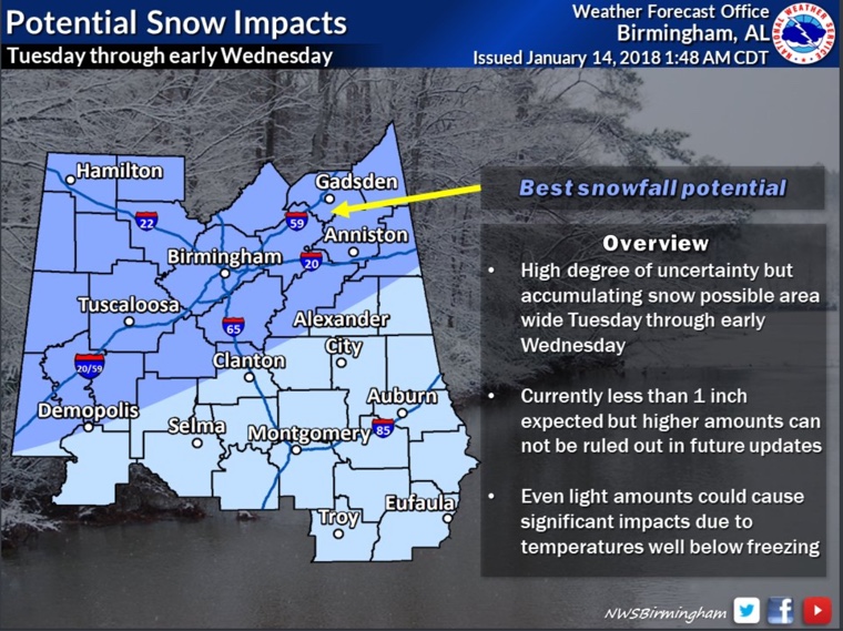
National Weather Service snowfall impact graphic for Tuesday.
All the focus on this forecast is on the potential for snowfall on Tuesday, and that does appear to be very possible. But the continuing cold is also an important topic of conversation. There will be a brief respite next weekend and a longer term moderation in the week following. Let’s dig into the details.
After a bitterly cold morning, all temperatures across North and Central Alabama are above freezing now. Afternoon highs will be in the 30s along and north of US-278. 40s will be common south of this.
A lobe of mid-level energy and mid-level moisture is swinging through the huge trough that is cover the eastern two-thirds of the United States. That energy is causing light snow across parts of Missouri and Arkansas, where winter weather advisories are in effect. Lows tonight will be in the lower and middle 20s across the area.
The clouds will begin to clear from the south Monday morning. With increasing sunshine on the holiday tomorrow, temperatures will approach lowers to middle 50s in places like Tuscaloosa, Demopolis and Montgomery. Readings at Birmingham, Anniston, Gadsden and Hamilton will center around 50F.
TUESDAY SNOW: Another shot of intensely cold air will start pouring southeastward across the Northern Plains and Midwest tonight and Monday. The cold front that is the vanguard of this airmass will arrive in Northwest Alabama after midnight and will move to the I-59 Corridor by early afternoon.
A band of light snow will move southeastward during the day, along and behind the cold front. It should affect places like Hamilton, Jasper and Cullman through mid-afternoon and move into the I-59 Corridor and places like Tuscaloosa, Birmingham, Anniston and Gadsden after that. The band should be weakening as it goes further southeast and its main support moves off to the northeast.
By mid-morning, ½ to 1 inch of snow will be on the ground in the Shoals area of Northwest Alabama. By noon, a dusting will extend to places like Fayette, Carbon Hill and Cullman with an inch on the ground in Hamilton. By 6 p.m., the dusting will reach places like Tuscaloosa, the Birmingham Metro and Gadsden. The snow will dust areas from Sumter and Hale County through Shelby County into Talladega and Anniston.
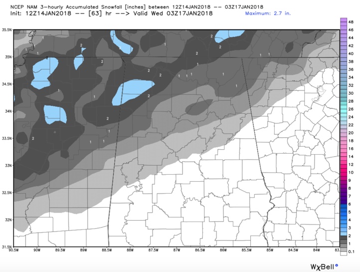
Here is the 12km NAM snowfall forecast by 9 p.m. Tuesday night:
TRAVEL PROBLEMS: Travel impacts are possible despite the light snowfall amounts that are expected since temperatures will be very cold as temperatures fall quickly into the middle and lower 20s behind the front. Check the latest forecasts, because there is still plenty of uncertainty in this forecast and its impacts.
BITTER COLD REMAINS WITH THE SNOW: Overnight Tuesday night, temperatures will plunge into the teens across the entire area. A few spots will get into the single digits. Only areas along and south of the Alabama River will remain in the 20s by Wednesday morning. Thursday morning will be nearly as cold.
Category: Alabama's Weather, ALL POSTS
About the Author (Author Profile)
Bill Murray is the President of The Weather Factory. He is the site's official weather historian and a weekend forecaster. He also anchors the site's severe weather coverage. Bill Murray is the proud holder of National Weather Association Digital Seal #0001 @wxhistorianSubscribe
If you enjoyed this article, subscribe to receive more just like it.


