Mesoscale Models are Calling for Additional Snow Development This Evening
A collaborative post by Bill Murray and Scott Martin.
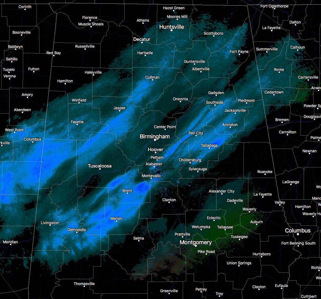
Radar continues to show a mix of snow flurries to snow showers across a good bit of North and Central Alabama at this time, with the heavier snow showers over an area from Moundville to Livingston in the southwestern parts of the area, with another heavier band stretching from Alabaster nearly to Demopolis. There is a bit of enhancement in Cullman County and some additional accumulations are possible there through 6:00 PM. Also looks like intensification of the snowfall is occurring on the front of the snow band.
At this point, it looks like the snow is over for locations in the northwestern parts of the state, including Florence, Muscle Shoals, Russellville, Hamilton, Double Springs, Vernon, and Millport. NWS Huntsville is In the process of clearing Madison and Morgan counties from the Winter Weather Advisory. The back edge of precipitation has pushed south and east of these counties.
The main event is yet to reach much of the east and southeastern parts of the area, including Selma, Montgomery, Clanton, Alexander City, Wedowee, Auburn, Troy, and Eufaula.
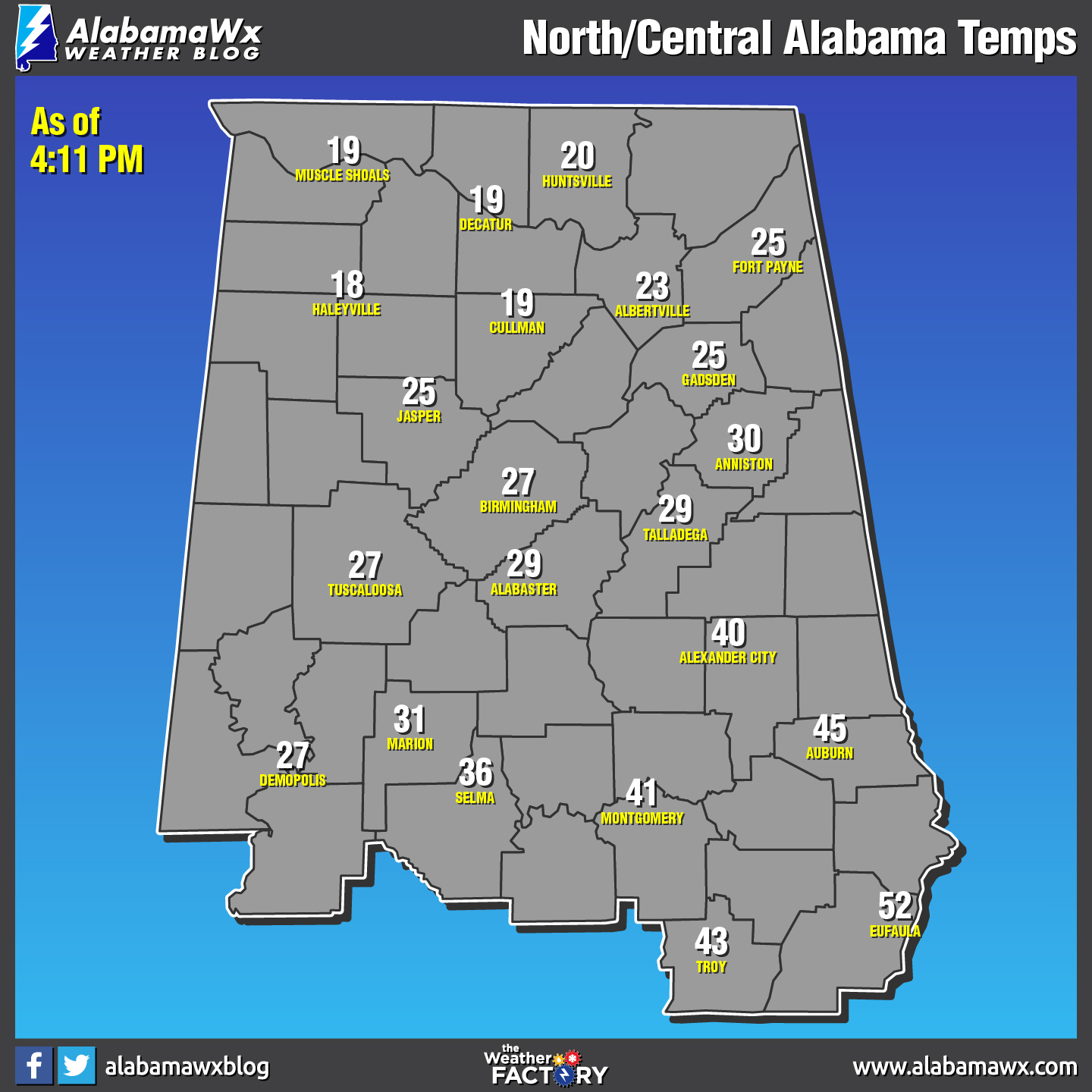
Temperatures have already reached the upper teens in the northwestern parts of the state, with 20s reaching as far south as Demopolis to Alabaster to Talladega. South and east of that line are ranging from the mid-30s to the lower 50s. The freezing mark will eventually be seen in the southeastern corner of the area by 9-10PM tonight.
A Hard Freeze Warning is in effect for all of the Central Alabama counties until 9:00 AM Wednesday, along with a Wind Chill Advisory. A Wind Chill Advisory is in effect for the North Alabama counties until 10:00 AM Wednesday. Please remember the 4-Ps… People, Pets, Plants, and Pipes. The cold air that will be in place can cause damage to plants and property, so be sure you take the proper steps to protect those. Be sure to check on the elderly and make sure they have proper and safe ways of staying warm. Bring those pets indoors as this cold will be harmful or even deadly.
Many schools have already decided to close in the northern half of the state. For the latest on closings and delays, please visit the ABC 33/40 Closings page by clicking here.
THE WORST IS YET TO COME FOR THE I-59 CORRIDOR; AREAS EAST AND SOUTHEAST AS WELL
The radar from Birmingham is showing two main bands of snow across Central Alabama. The southeastward movement has slowed a bit, and the radar echoes are getting heavier. This has been well foretold by the mesoscale models over the past couple of hours.
Here is the HRRR, WRF and 3km NAM for 4 p.m., 6 p.m. and 9 p.m. showing additional snow development.
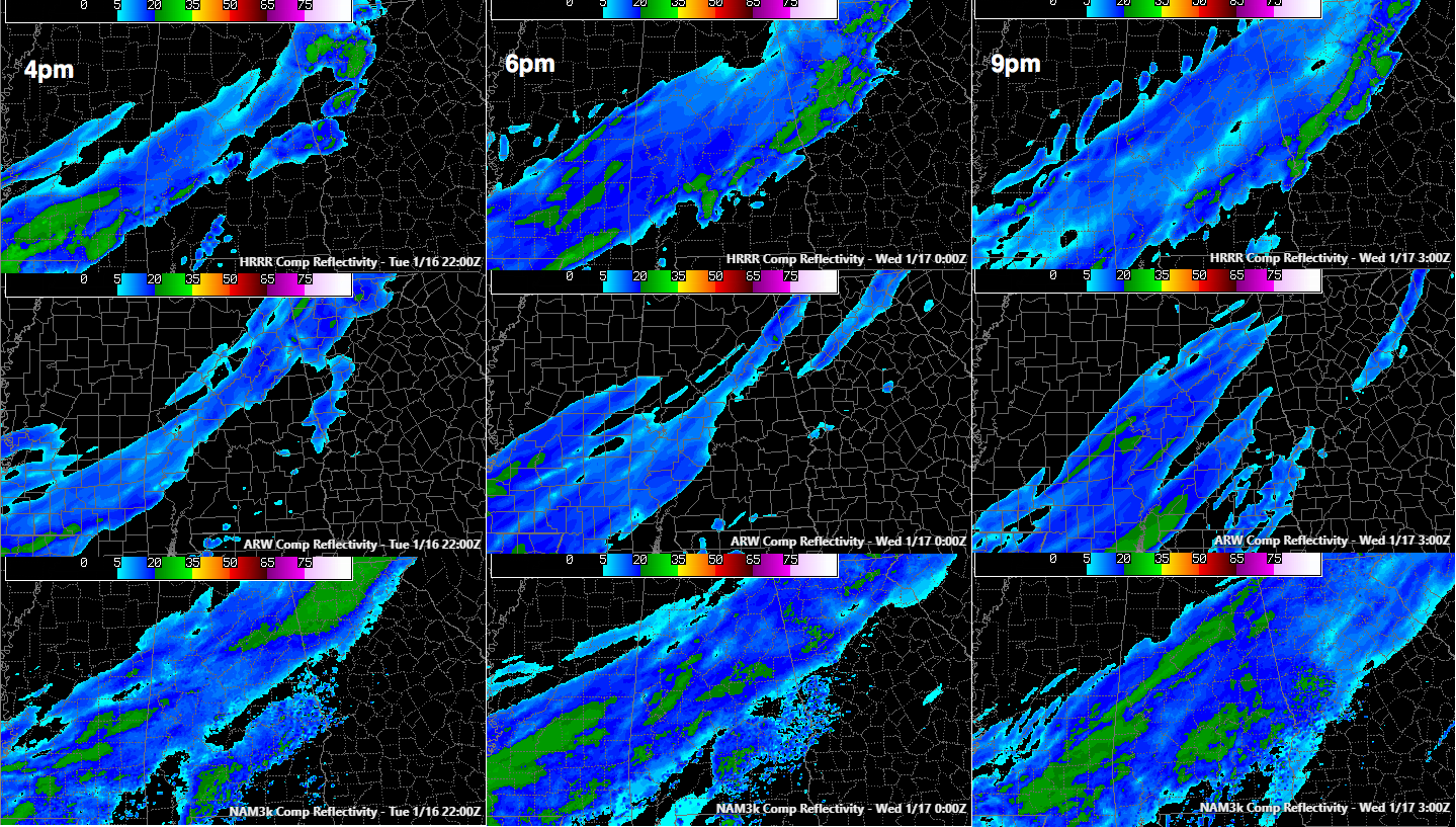
If it pans out, that means several more hours of snow is likely for Pickens, Sumter and Greene Counties through Tuscaloosa, Bibb and Perry Counties into Jefferson Shelby and Chilton Counties.
The snow should begin to move out by 8-9 p.m. over western Counties, by 10 p.m. in Tuscaloosa and 11 p.m. in Birmingham.
The heavier snow will spread into eastern Alabama from Blount and St. Clair Counties over to the Georgia border including Cherokee, Calhoun and Cleburne Counties, southward through Talladega, Clay and Randolph Counties into the hours after midnight.
Snowfall amounts should be less than one inch in all these areas, but with temperatures heading toward overnight lows near 10F across the area, roads will become icy and hazardous shortly after any heavier snow falls.
FURTHER SOUTH
Snow will push southeastward into the I-85 Corridor between 9-10 p.m. It will push into Southeast Alabama by 5-6 a.m.
STAY OFF THE ROADS
Multiple roads throughout the northwestern parts of the area have been deemed impassable by EMA and Law Enforcement officials, and Winston County EMA has already announced that all roads in the county will be closed as of 6:30 p.m. Fayette County just announced their roads are closed as of 4 p.m. Walker County EMA has treated some bridges, but only for emergency traffic tonight. Roads that may be closed soon. Secondary roads are not in good shape in areas west and north of Birmingham.
Conditions are deteriorating in parts of Jefferson County as well. As the temperature continues to drop and the snow continues to fall, roadways will begin to become impassable as the snowfall continues to march eastward across the state.
We recommend that everyone stay off the roads as much as possible overnight.
SLOW IMPROVEMENT TOMORROW
Skies will clear overnight, but temperatures tomorrow will have a hard time getting above freezing across the northern half of the state. Most of the improvement will come from sublimation, which is the direct change from a solid to a gas. But roads could remain hazardous through much of tomorrow and into Thursday in some of the more impacted locations.
Keep checking back with us on the blog throughout the evening for the latest updates, and follow us on Twitter and Facebook (@AlabamaWxBlog).
Category: Alabama's Weather, ALL POSTS
About the Author (Author Profile)
Scott Martin is an operational meteorologist, professional graphic artist, musician, husband, and father. Not only is Scott a member of the National Weather Association, but he is also the Central Alabama Chapter of the NWA president. Scott is also the co-founder of Racecast Weather, which provides forecasts for many racing series across the USA. He also supplies forecasts for the BassMaster Elite Series events including the BassMaster Classic.Subscribe
If you enjoyed this article, subscribe to receive more just like it.


