A Brief Check On Central Alabama’s Weather Situation At 11:00 AM
RADAR CHECK AT 11:00 AM
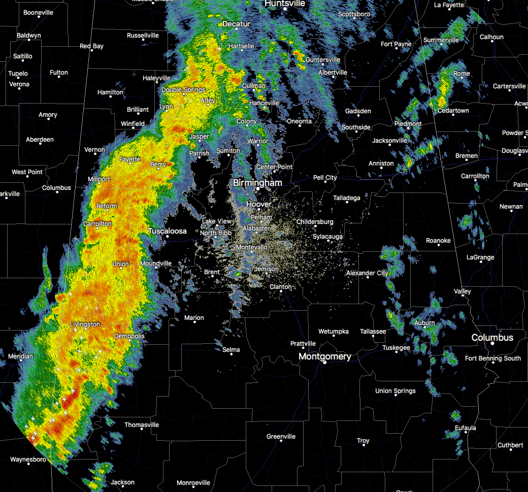
The line of showers and storms now currently stretch from Harvest in Madison County in North-Central Alabama, all of the way down to Silas in Choctaw County in Southwestern Alabama. The strongest cells embedded in the line are currently located in the western portions of Choctaw County. The southern part of this line has been the focal point for the past hour as a couple of tornado warnings were issued. At this point, we haven’t seen any reports of damage.
The line will be in the Tuscaloosa metropolitan area within the next 15-25 minutes and is currently moving into the cities of Jasper, Berry, and Demopolis.
I still believe the timing is on-track for the remainder of the state today… now until 2:00 PM for the western parts of the area (Demopolis, Tuscaloosa, Jasper), 12:00 PM – 4:00 PM for the central parts (Selma, Clanton, Birmingham, Gadsden), and 2:00 PM – 6:00 PM for the eastern parts (Montgomery, Troy, Alexander City, Anniston).
The HRRR is still holding pretty true to the earlier run, keeping the instability over the southern portions of the area along and ahead of the main squall line. Dewpoints are still modeled to be in the upper 50s in the northern half of the area, with lower to mid-60 degree dewpoints in the southern half.
The Storm Prediction Center continues to have the southern-half of Central Alabama in a Marginal Risk for severe storms (south of a line from Reform to Windham Springs to Alabaster to Opelika). The main threat will be from damaging thunderstorm wind gusts up to 60 MPH, with a very small risk of a brief isolated tornado or two.
We’ll continue to have updates throughout the day on the AlabamaWx Weather Blog at AlabamaWx.com and on our Facebook and Twitter feeds at @AlabamaWxBlog.
Category: Alabama's Weather, ALL POSTS
About the Author (Author Profile)
Scott Martin is an operational meteorologist, professional graphic artist, musician, husband, and father. Not only is Scott a member of the National Weather Association, but he is also the Central Alabama Chapter of the NWA president. Scott is also the co-founder of Racecast Weather, which provides forecasts for many racing series across the USA. He also supplies forecasts for the BassMaster Elite Series events including the BassMaster Classic.Subscribe
If you enjoyed this article, subscribe to receive more just like it.


