One More Dry Day; Then Some Rain For The Weekend
SUNNY JANUARY AFTERNOON: Temperatures are in the 55-60 degree range across North/Central Alabama this afternoon under a cloudless sky. Tonight will be clear and cold; we drop to near 30 degrees early tomorrow morning. And, we will enjoy one more dry day tomorrow with a partly to mostly sunny sky… the high will be at or just over 60 degrees. Clouds increase tomorrow night.
THE ALABAMA WEEKEND: A wave of low pressure will move through the northern Gulf of Mexico, meaning some rain at times for our state both days. Expect some rain at times Saturday with high between 57 and 60 degrees. The most widespread rain should come Saturday night into Sunday morning; the rain ends from west to east by the afternoon hours Sunday. Rain amounts over the northern half of the state should be 1/2″ or less, with potential for heavier values over South Alabama. Some thunder is possible, but there is no risk of severe thunderstorms with the surface low passing to the south.
NEXT WEEK: The first half of the week looks cold and dry; looks like we won’t get past the mid 40s Tuesday. Early morning lows will be well down in the 20s early Tuesday and Wednesday morning, with potential for upper teens for colder spots.
A cold front will bring a rain back in here Thursday, and Thursday night, followed by sharply colder air for Friday and the following weekend (February 2-4). The GFS hints at some risk of flurries Thursday night as the cold air begins to arrive, but the 12Z European model shows no show, and ensemble output suggests no real threat of any “winter mischief” for now.
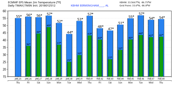
The overall pattern for the first half of February suggests a series of cold fronts that could very well keep temperatures around here, and over much of the eastern U.S., below average. Of course, no skill in a specific forecast beyond 7-10 days. See the Weather Xtreme video for maps, graphics, and more details.
DROUGHT CONDITIONS CREEPING IN: The new U.S. Drought Monitor data released this morning shows drought conditions creeping higher across Alabama…
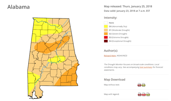
Birmingham has received less than one inch of rain since the first of the year (0.94″), and the total since December 1 is 4.95″, which is 3.19″ below average.
BEACH FORECAST: Click here to see the AlabamaWx Beach Forecast Center page. The Beach Forecast is partially underwritten by the support of Brett/Robinson Vacation Rentals in Gulf Shores and Orange Beach. Click here to see Brett/Robinson’s Hot Deals now!
WEATHER BRAINS: Don’t forget you can listen to our weekly 90 minute netcast anytime on the web, or on iTunes. This is the show all about weather featuring many familiar voices, including our meteorologists here at ABC 33/40.
CONNECT: You can find me on all of the major social networks…
Facebook
Twitter
Google Plus
Instagram
Pinterest
Snapchat: spannwx
I had a great time today back in my childhood hometown of Greenville seeing the kids at Greenville Middle School… be looking for them on the Pepsi KIDCAM today at 5:00 on ABC 33/40 News! The next Weather Xtreme video will be posted here by 7:00 a.m. tomorrow…
Category: Alabama's Weather, ALL POSTS, Weather Xtreme Videos
About the Author (Author Profile)
James Spann is one of the most recognized and trusted television meteorologists in the industry. He holds the AMS CCM designation and television seals from the AMS and NWA. He is a past winner of the Broadcast Meteorologist of the Year from both professional organizations.Subscribe
If you enjoyed this article, subscribe to receive more just like it.


