A Few Breaks In The Clouds At Midday, But Rain Is Expected Later Today
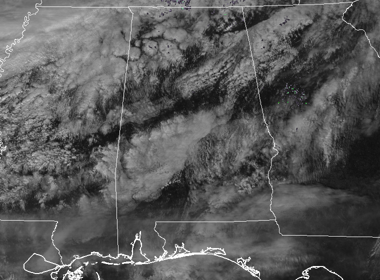
Everyone across Central Alabama is enjoying some rather nice temperatures at this point on your Thursday, ranging from the mid-50s to the mid-60s. The temperature spread is not uniform as usual due to the cloud cover across the state, but temperatures are definitely warmer where the sun is able to break through. Radar at this point is showing a few echoes out there in the southwestern parts of the area near York, Demopolis, and Marion. A few raindrops may be reaching the ground, but most of this is evaporating. Same story up in the northwestern parts of the area, mainly in portions of Marion and Winston counties… echoes are there but are the drops making it to the surface.
At this point, the cold front is still well off to our northwest but will be moving through the area later this afternoon and through the evening and overnight hours. A few scattered showers will begin to develop later this afternoon, but the main rain activity should arrive with the cold front around rush hour in the northwestern parts of the area. The front should make it to Birmingham, Tuscaloosa, and Gadsden by 6-7PM, and to the Montgomery area by 10PM-midnight. Rainfall will come to an end rather quickly after the front moves through and out of the area well before sunrise on Friday morning. Afternoon highs will be in the upper 50s to the upper 60s, with lows dropping into the upper-20s to the mid-40s from northwest to southeast.
Friday’s weather looks to be a nice and cool day with decreasing clouds, and a little breezy at times. Winds will be out of the north and northwest averaging 5-15 MPH, and that will make the daytime highs feel much cooler at times. Highs will be in the lower 40s to the mid-50s. Clouds will begin to move back in during the late night and into the overnight hours, but we will remain dry. Overnight lows will be in the mid-20s to the lower 30s.
ON THIS DAY IN WEATHER HISTORY
1951 – The greatest ice storm of record in the U.S. produced glaze up to four inches thick from Texas to Pennsylvania causing twenty-five deaths, 500 serious injuries, and 100 million dollars damage. Tennessee was hardest hit by the storm. Communications and utilities were interrupted for a week to ten days.
ADVERTISE WITH US
Don’t miss out! Just in the first 30 days of the year, we have enjoyed over 2.3 million page views at AlabamaWx.com. We can customize a creative, flexible and affordable package that will suit your organization’s needs. Contact Bill Murray at (205) 687-0782.
WEATHERBRAINS
Check out the show at www.WeatherBrains.com. You can also subscribe on iTunes. You can watch the show live at live.bigbrainsmedia.com. You will be able to see the show on the James Spann 24×7 weather channel on cable or directly over the air on the dot 2 feed.
Category: Alabama's Weather, ALL POSTS
About the Author (Author Profile)
Scott Martin is an operational meteorologist, professional graphic artist, musician, husband, and father. Not only is Scott a member of the National Weather Association, but he is also the Central Alabama Chapter of the NWA president. Scott is also the co-founder of Racecast Weather, which provides forecasts for many racing series across the USA. He also supplies forecasts for the BassMaster Elite Series events including the BassMaster Classic.Subscribe
If you enjoyed this article, subscribe to receive more just like it.


