Some Rain Tonight; Sharply Colder Tomorrow
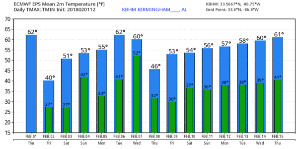
MILD AFTERNOON: Temperatures are in the 60s across much of Alabama this afternoon, but clouds are thickening, and some patches of light rain are beginning to show up on radar ahead of a cold front. We will mention the chance of rain at times through midnight tonight; moisture will be limited, and rain amounts will be 1/4″ or less for most places.
COLDER TOMORROW: Temperatures tomorrow will be about 20 degrees colder than today; despite a mostly sunny sky we won’t get past the mid 40s with a chilly north wind. Then, we go well below freezing late tomorrow night… most places around here will see a low between 21 and 25 early Saturday morning.
MORE QUICK CHANGES FOR THE WEEKEND: We warm nicely during the day Saturday… the high by afternoon will be in the mid 50s with a mix of sun and clouds. Clouds will thicken late in the day, and a soaking rain is likely late Saturday night into Sunday morning. The main window for rain over the weekend will come from about 12:00 midnight Saturday through 12:00 noon Sunday; rain amounts will be in the one inch range. Clouds will linger through Sunday afternoon with a high in the mid 50s.
NEXT WEEK: Monday will feature a good supply of sunshine with a high in the low 50s. Then, on Tuesday, clouds increase during the day as temperatures rise into the low 60s. Rain and thunderstorms are likely Tuesday night into Wednesday morning; we will be monitoring for potential for strong to severe storms as we get closer since there will be some surface based instability involved along with stronger wind fields.
The sky will clear Wednesday night, and Thursday and Friday look dry with seasonal temperatures.
We stress there are no signs of any significant snow or ice issues for Alabama for the next seven to ten days.
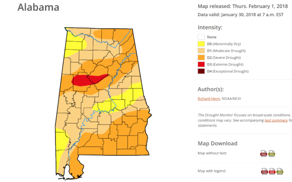
DROUGHT MONITOR: The weekly data was released this morning, and it shows drought conditions continuing to ramp up across Alabama. Parts of Tuscaloosa and Jefferson Counties are in “extreme drought” conditions. On the positive side, we are in an active pattern that will bring frequent rain events to our state for the foreseeable future, which should help.
See the Weather Xtreme video for maps, graphics, and more details.
BEACH FORECAST: Click here to see the AlabamaWx Beach Forecast Center page. The Beach Forecast is partially underwritten by the support of Brett/Robinson Vacation Rentals in Gulf Shores and Orange Beach. Click here to see Brett/Robinson’s Hot Deals now!
WEATHER BRAINS: Don’t forget you can listen to our weekly 90 minute netcast anytime on the web, or on iTunes. This is the show all about weather featuring many familiar voices, including our meteorologists here at ABC 33/40.
CONNECT: You can find me on all of the major social networks…
Facebook
Twitter
Google Plus
Instagram
Pinterest
Snapchat: spannwx
I enjoyed seeing the 4th/5th grades today at West Point Intermediate School in Cullman County… be looking for them on the Pepsi KIDCAM today at 5:00 on ABC 33/40 News! The next Weather Xtreme video will be posted here early tomorrow morning by 7:00…
Category: Alabama's Weather, ALL POSTS, Weather Xtreme Videos
About the Author (Author Profile)
James Spann is one of the most recognized and trusted television meteorologists in the industry. He holds the AMS CCM designation and television seals from the AMS and NWA. He is a past winner of the Broadcast Meteorologist of the Year from both professional organizations.Subscribe
If you enjoyed this article, subscribe to receive more just like it.


