Flood Watch Issued For All Of North Alabama From 12AM Saturday To 6PM Sunday
URGENT – IMMEDIATE BROADCAST REQUESTED
Flood Watch
National Weather Service Huntsville AL
409 AM CST Fri Feb 9, 2018
Heavy Rainfall and Potential Flooding This Weekend
A developing storm system over the central Gulf Coast states will translate into multiple waves of showers and potentially heavy rainfall starting late tonight and continue through Sunday. Total rainfall amounts around 2 to 3 inches are possible with locally higher amounts. The threat for heavy rainfall and flooding will come to an end Sunday afternoon as a low pressure system and attendant cold front move eastward across the area.
FLOOD WATCH IN EFFECT FROM LATE TONIGHT THROUGH SUNDAY AFTERNOON
The National Weather Service in Huntsville has issued a
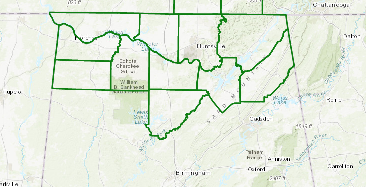
- Flood Watch for portions of Alabama and southern middle Tennessee, including the following areas, in Alabama, Colbert, Cullman, De Kalb, Franklin AL, Jackson, Lauderdale, Lawrence, Limestone, Madison, Marshall, and Morgan. In southern middle Tennessee, Franklin TN, Lincoln, and Moore.
- From late tonight through Sunday afternoon.
- Numerous to widespread showers, some containing heavy rainfall, will develop and spread eastward into the area starting late tonight. Total rainfall amounts around 2 to 3 inches are possible, with locally higher amounts. Excessive runoff may result in flooding of some roads and low lying areas, along with area rivers and streams. The flooding threat is expected to end late Sunday afternoon from west to east with the passage of a frontal boundary.
- People in the watch area should be aware for the possibility of heavy rainfall and flooding. Do not drive through water that covers a road.
PRECAUTIONARY/PREPAREDNESS ACTIONS…
A Flood Watch means there is a potential for flooding based on current forecasts.
You should monitor later forecasts and be alert for possible Flood Warnings. Those living in areas prone to flooding should be prepared to take action should flooding develop.
Category: ALL POSTS, Severe Weather
About the Author (Author Profile)
Scott Martin is an operational meteorologist, professional graphic artist, musician, husband, and father. Not only is Scott a member of the National Weather Association, but he is also the Central Alabama Chapter of the NWA president. Scott is also the co-founder of Racecast Weather, which provides forecasts for many racing series across the USA. He also supplies forecasts for the BassMaster Elite Series events including the BassMaster Classic.Subscribe
If you enjoyed this article, subscribe to receive more just like it.


