More Heavy Rain Overnight, Strong Storms to the Southeast of I-59 on Sunday
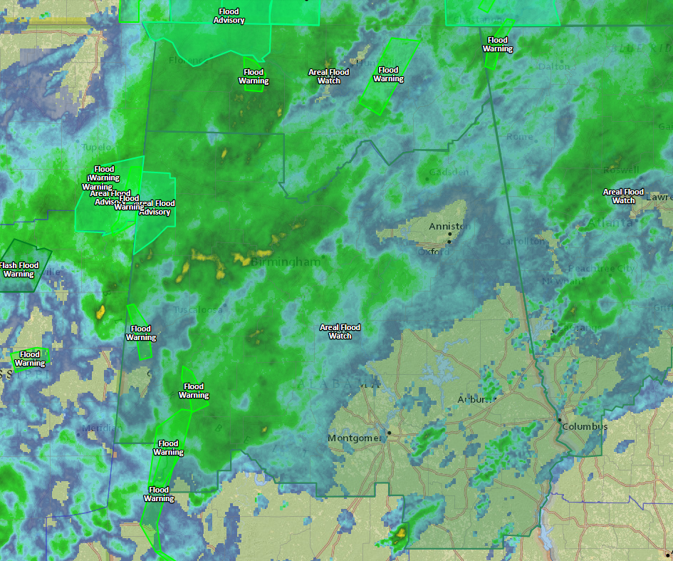
Current flood watches, advisories and warnings with radar.
It is a rainy night across about the northwestern half of Alabama, with moderate to occasionally heavy showers covering areas west of I-65. These moderate to heavy showers extend into eastern Mississippi.
Rainfall amounts have generally been light to moderate, averaging about one half to one inch in areas within about 50 miles west of I-59. Higher amounts have impacted Northwest Alabama, including parts of Marion, Lamar, Winston and Franklin Counties, where 1-3 inch amounts have been common.
Recent rainfall totals include:
0.45 at the Birmingham Airport
1.12 at Tuscaloosa
0.83 at the Shelby County Airport
0.32 at Anniston
0.52 at the Bessemer Airport
I have picked up 0.63 inches here off Acton Road since midnight.
Rainfall is expected to intensify once again over Northwest Alabama over the next few hours as a strengthening upper-level jet enhances upward motion.
Most areas west of I-59 should receive at least another 1 inch of rain on average overnight. Additional amounts of 2-3 inches could fall in areas which have seen some of the heaviest rain so far from this system. This could lead to flooding and warnings are quite possible later tonight.
There is already a flood advisory for much of Lamar County and a couple of Flood Warnings in the Tennessee Valley. A flash flood watch continues for all of Central and North Alabama until tomorrow evening.
The airmass over Central Alabama is slightly unstable, but so far, no lightning this evening. All of the thunder has been limited to areas near the Gulf Coast. There were severe thunderstorm and even a tornado warning in Southwest Alabama earlier though. I don’t think we will deal with severe weather overnight across Central Alabama, although areas south of I-20 have a marginal severe weather risk and there is a slight risk along the Gulf Coast.
Lows tonight will only drop to around 60F.
Rain should push south of I-59 by mid-morning, and I am hopeful that runners at the huge Mercedes Marathon in downtown Birmingham will run in mostly dry conditions.
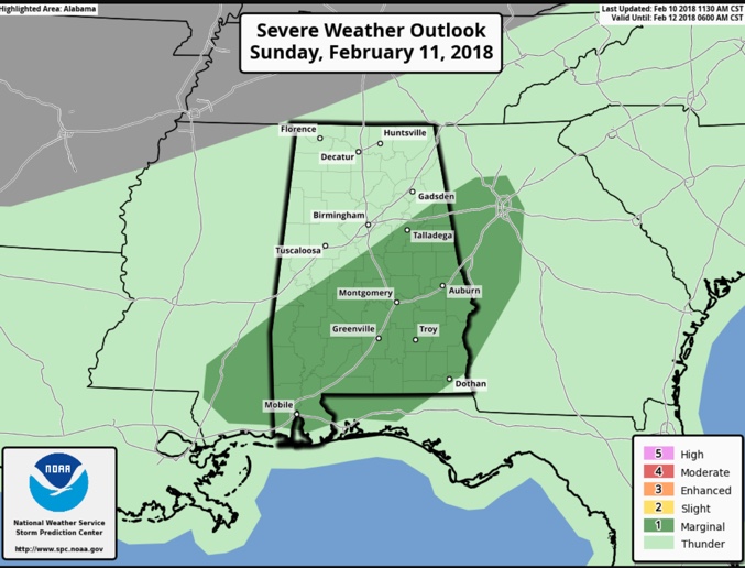
Tomorrow’s severe weather outlook from the SPC. Darker green is the marginal risk area.
A marginal risk of severe weather covers areas south of I-59 tomorrow as storms form by afternoon ahead of an approaching cold front. The main threat will be damaging straight-line winds. With a few breaks in the clouds, things could get a little more interesting across the area at some point, so we will be monitoring it closely.
Areas northwest of I-59 may get by with just a few additional showers during the day. Highs will approach 70F.
Category: Alabama's Weather, ALL POSTS
About the Author (Author Profile)
Bill Murray is the President of The Weather Factory. He is the site's official weather historian and a weekend forecaster. He also anchors the site's severe weather coverage. Bill Murray is the proud holder of National Weather Association Digital Seal #0001 @wxhistorianSubscribe
If you enjoyed this article, subscribe to receive more just like it.


