SPC Thinks Severe Weather Threat May Ramp Up Over South into South Central Alabama Later This Evening
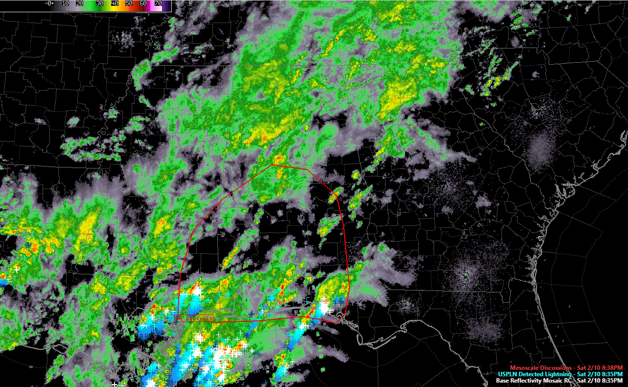
Precipitation, lightning and the SPC mesoscale discussion area highlighted in red
The Storm Prediction Center has just issued a Mesoscale Discussion for much of the southern half of Alabama, southeastern Mississippi and the Florida Panhandle for an increasing threat of severe weather, including the possibility of an isolated tornado or damaging winds.
Storms have strengthened in the past couple of hours over the northern Gulf of Mexico, southeastern Mississippi and Northwest Florida.
This activity will lift northeastward into South and South Central Alabama along with increasing instability and wind shear.
The SPC does not expect to have to issue a watch at this time.
We will of course be monitoring the threat throughout the night.
Here is the complete text of the discussion:
Mesoscale Discussion 0063
NWS Storm Prediction Center Norman OK
0829 PM CST Sat Feb 10 2018
Areas affected…Southeast Mississippi…much of southern Alabama
and the Florida Panhandle
Concerning…Severe potential…Watch unlikely
Valid 110229Z – 110500Z
Probability of Watch Issuance…20 percent
SUMMARY…Storms may increase in coverage and intensity through
evening, with a brief tornado or localized severe wind gust
possible. A watch is not anticipated at this time due to expected
isolated nature of potential severe storms.
DISCUSSION…A moist and generally weakly unstable air mass has been
in place across the region for hours, along with moderately strong
southwest flow aloft. With little focus at the surface, storm
activity has been largely disorganized except for a few confluence
bands at times from southern MS into the FL Panhandle. Despite weak
surface winds, shear profiles have aided a few of these storms with
some weak rotation at times.
Recently, an increase in storm coverage has occurred over the
northern Gulf of Mexico, and now affecting parts of southeast LA,
southern MS/AL and the FL Panhandle. These storms should continue to
shift northward with time.
Shear profiles are expected to become slightly more favorable over
the next several hours as a low-amplitude upper feature develops
northeastward. Instability will remain nearly the same, except for
some increase northward into central AL where MUCAPE is currently
very meager. Given the increase in storm coverage as well as shear,
and some upper support, isolated severe storms are possible. The
surface air mass remains marginally buoyant, and may support a brief
tornado risk with any sustained supercell, within one or more
clusters and/or embedded within a larger precipitation shield.
..Jewell/Thompson.. 02/11/2018
Category: Alabama's Weather, ALL POSTS
About the Author (Author Profile)
Bill Murray is the President of The Weather Factory. He is the site's official weather historian and a weekend forecaster. He also anchors the site's severe weather coverage. Bill Murray is the proud holder of National Weather Association Digital Seal #0001 @wxhistorianSubscribe
If you enjoyed this article, subscribe to receive more just like it.


