Mid-Morning Alabama Weather Update
Showers continue across North and Central Alabama on this Sunday morning. Temperatures are around 60F over the Tennessee Valley and in the lower and middle 60s across Central Alabama.
The cold front is knocking on the door of Northwest Alabama at this hour and you don’t have to go very far back into the colder airmass to find some impressively cold readings. It is 34F in Memphis, 18F in Springfield MO and -2F at Grand Island NE.
But the good news is that the much colder air won’t make it into Alabama this week. The upper-level disturbance that is carving out the trough over the Rockies and Plains is weakening and we stay basically in a southwesterly flow aloft all week, blocking the cold air’s advance.
We will see dewpoints fall tonight, so the Muggies will be gone for Monday. BUt moisture levels will start creeping back up for the rest of the week until a front arrives Friday. Showers will remain in the forecast through the week with that southwesterly flow aloft continuing, but no day will be a washout. Highs will edge back toward 70 degrees for Wednesday and Thursday.
For this afternoon, we continue to monitor a severe weather and a flood threat.
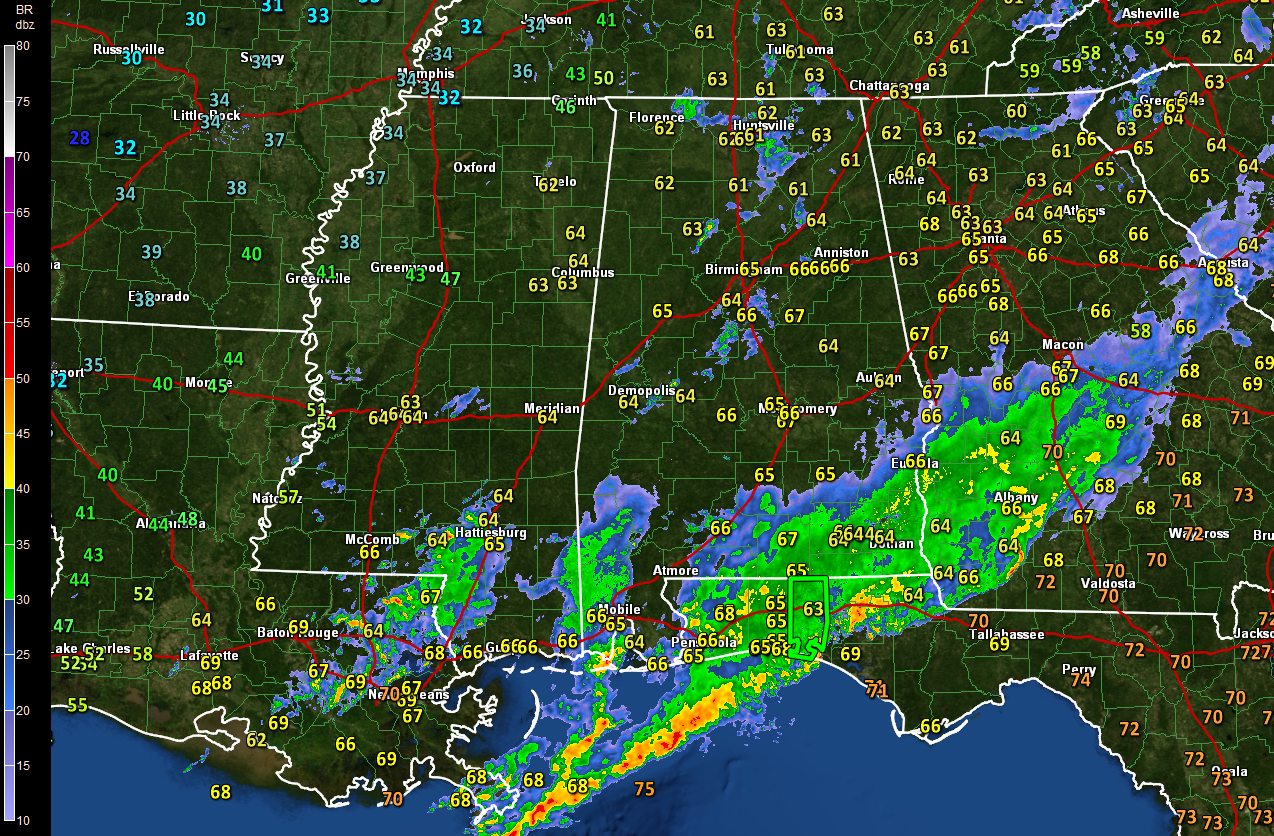
The SPC maintains a marginal risk for severe weather, their base level risk, for areas south of a line from Roanoke to Selma to Thomasville. There is a chance of damaging winds and an isolated tornado in places like Montgomery, Greenville, Auburn, Troy, Dothan and Mobile. Thunderstorms will overspread this area this afternoon with some decent wind shear. Activity will begin weakening this evening, ending the severe weather threat.
The NWS Birmingham maintains a flash flood watch for Autauga, Barbour, Bullock, Calhoun, Chambers, Cherokee, Chilton, Clay, Cleburne, Coosa, Dallas, Elmore, Lee, Lowndes, Macon, Montgomery, Pike, Randolph, Russell, Talladega and Tallapoosa Counties until 6 p.m.
Here is the simulated radar from the HRRR mesoscale model for this afternoon:

As you can see, rain is expected to overspread areas south of I-59 this afternoon with scattered showers to the north. Skies will remain cloudy through early tomorrow. Highs today will range between 65-70F, with the warmest temperatures to the south. Lows tonight will fall into the 40s.
Category: Alabama's Weather, ALL POSTS
About the Author (Author Profile)
Bill Murray is the President of The Weather Factory. He is the site's official weather historian and a weekend forecaster. He also anchors the site's severe weather coverage. Bill Murray is the proud holder of National Weather Association Digital Seal #0001 @wxhistorianSubscribe
If you enjoyed this article, subscribe to receive more just like it.


