

Not Much Sun Through The Weekend
RADAR CHECK: Rain is falling this afernoon over the Tennessee Valley of far North Alabama, back down into the northern half of Mississippi. Otherwise, the sky is mostly cloudy across Alabama this afternoon with temperatures generally in the 60s.
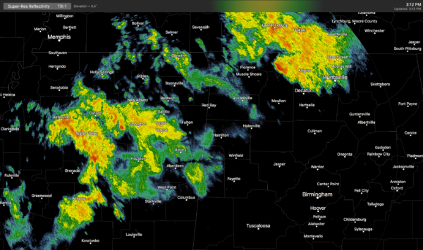
Scattered showers remain possible through the evening hours, then we expect only isolated showers late tonight.
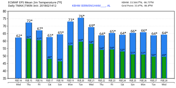
TOMORROW AND FRIDAY: The maps continue to show a strong upper high over the Gulf of Mexico, nosing up into the Gulf Coast region. And, a cold upper trough over the western U.S. Moist air will remain trapped across the Deep South, so the sky will remain mostly cloudy tomorrow and Friday, and we will continue to mention a chance of showers, with the best coverage over the northern third of Alabama. Any showers over the southern half of the state should be few and far between. We rise into the low 70s tomorrow; Friday’s high will be in the mid to upper 60s.
THE ALABAMA WEEKEND: A cold front will stall out near the Tennessee state line Saturday; we will continue to mention a chance of showers Saturday over the northern half of the state. It won’t rain all day, and the rain won’t be especially heavy (nothing like the big downpours last Saturday). Showers will thin out Sunday, and the sun might even peek out a time or two as slightly drier air seeps into the state. Highs over the weekend will be in the 60s.
NEXT WEEK AND BEYOND: Not much change in the overall weather pattern. The week will be mostly cloudy, temperatures will remain very mild, and we will have some risk of showers pretty much daily, with the best coverage over the northern half of Alabama. We will see highs in the warm 70s Monday and Tuesday, with 60s likely Wednesday through Friday.
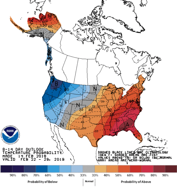
No sign of any Arctic air intrusions into our state for the rest of February as the upper high over the Gulf Coast region persists. And, no sign of any severe thunderstorm or flooding issues as well, with the heaviest rain axis north of Alabama.
BEACH FORECAST: Click here to see the AlabamaWx Beach Forecast Center page.
WEATHER BRAINS: Don’t forget you can listen to our weekly 90 minute netcast anytime on the web, or on iTunes. This is the show all about weather featuring many familiar voices, including our meteorologists here at ABC 33/40.
CONNECT: You can find me on all of the major social networks…
Facebook
Twitter
Google Plus
Instagram
Pinterest
Snapchat: spannwx
I had a great time today visiting with the second graders at Gardendale Elementary School… be looking for them on the Pepsi KIDCAM on ABC 33/40 News at 5:00! The next Weather Xtreme video will be posted here by 7:00 a.m. tomorrow…
Category: Alabama's Weather, ALL POSTS, Weather Xtreme Videos
About the Author (Author Profile)
James Spann is one of the most recognized and trusted television meteorologists in the industry. He holds the AMS CCM designation and television seals from the AMS and NWA. He is a past winner of the Broadcast Meteorologist of the Year from both professional organizations.Subscribe
If you enjoyed this article, subscribe to receive more just like it.


