Is It Early May? Very Nice Across Central Alabama At Midday
Conditions Across Central Alabama At 1:10 PM
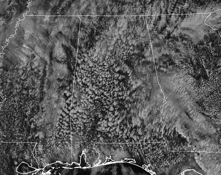
Skies are partly to mostly cloudy out there, but there is enough breaks in between those clouds to allow for a little sunshine to make it to the surface. Temperatures are running from the mid-70s to the lower 80s across the area, with Birmingham sitting at 81 degrees, easily breaking the old record of 78 degrees set back in 1986. We’ll have to wait a little later this evening before we get the official word from NWS Birmingham, but it looks like my record-breaker animated GIF will be seen again on the blog today. Stay tuned!
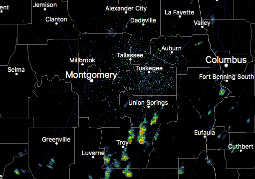
There are a few showers showing up over the southeastern parts of the area, mainly over Pike and Bullock counties. These showers are mainly moving to the north and we haven’t seen any lightning associated with these so far.
For The Remainder Of Your Tuesday
We’ll continue to have partly cloudy skies across the area throughout the rest of the afternoon and into the early evening hours across the area, with a very small risk of a few showers over the eastern half of the area. Highs are expected to reach the upper 70s to the mid-80s, and a few record highs may fall once again. For tonight, skies will continue to be partly to mostly cloudy across the area. We do have a small risk for a few scattered showers, but the higher possibilities will be in the eastern half of the area. With that being said, the highest risk is only around 30%. Overnight lows will be in the mid to upper 60s.
Wednesday’s Weather
The latest NAM model run is keeping much of Central Alabama dry throughout the daytime and into the early evening hours on Wednesday, but there is still a very small chance of a stray shower or two over mainly the western half of the area. Afternoon highs will once again be pushing the record territory, making it into the upper 70s to the lower 80s under mostly cloudy skies. Those highs could creep a little higher if there are any larger breaks in the clouds, especially in the afternoon hours. For Wednesday night, skies will continue to be mostly cloudy with a very small risk of a few showers, mainly over the western and northwestern parts of the area. Lows will only dip down into the lower to mid-60s.
Beach Forecast Center
Is it warm or cold at the beach today? Will it rain in two days? Get the latest forecast for the beaches from Fort Morgan to Panama City on our Beach Forecast Center page. There, you can select the forecast of the region that you are interested in.
WeatherBrains
Don’t forget you can listen to our weekly 90 minute netcast anytime on the web at WeatherBrains.com or on iTunes. This is the show all about weather featuring many familiar voices, including the meteorologists at ABC 33/40.
On This Day In Weather History
1989 – Thunderstorms developing during the early afternoon produced severe weather from eastern Texas to Alabama and northwest Florida. Thunderstorms spawned a dozen tornadoes during the afternoon and evening. Thunderstorms also produced 90 mph winds around Vicksburg MS, and 100 mph winds around Jackson MS.
Category: Alabama's Weather, ALL POSTS
About the Author (Author Profile)
Scott Martin is an operational meteorologist, professional graphic artist, musician, husband, and father. Not only is Scott a member of the National Weather Association, but he is also the Central Alabama Chapter of the NWA president. Scott is also the co-founder of Racecast Weather, which provides forecasts for many racing series across the USA. He also supplies forecasts for the BassMaster Elite Series events including the BassMaster Classic.Subscribe
If you enjoyed this article, subscribe to receive more just like it.


