Warm Through Friday; Only Isolated Showers
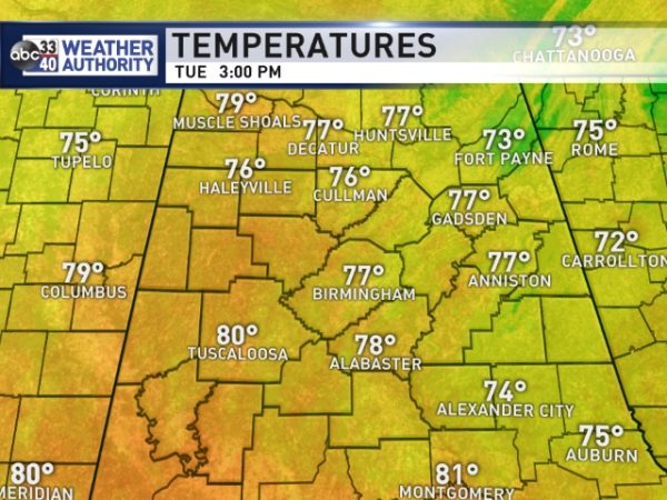
TEMPERATURES REMAIN AT RECORD LEVELS: As of 3:00, Birmingham’s maximum temperature today is 78; that ties the record high for February 20, last set in 1986. One of the warmest places in the state is Tuscaloosa with 80 degrees… that is one degree shy of the record high for the date, 81 set in 2014. We have a mix of sun and clouds, and a few isolated showers are over Southeast Alabama… mostly east of I-65, and south of I-85. Those showers will dissipate once the sun goes down.
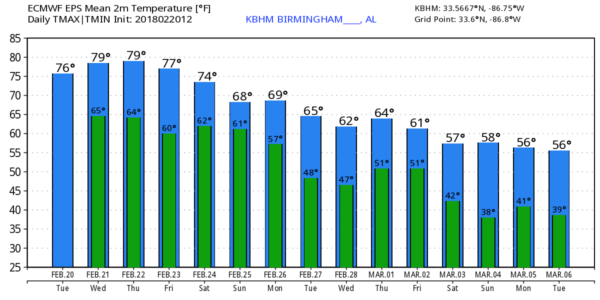
TOMORROW THROUGH FRIDAY: The high amplitude pattern will persist over the nation, with very cold air over the northern and western states, and spring like warmth for the South and East. The upper ridge will hold across the Deep South, meaning highs around 80 degrees each afternoon. And, while a few showers could pop up during the afternoon and evening hours around here, the most widespread rain will remain north and west of Alabama along the sharp surface front that represents the leading edge of the very cold air. Bottom line is that warm, and mostly dry weather will continue through Friday. We are forecasting a high of 82 in Birmingham Friday; that is within one degree of the all time record for February, 83 set on Feb 8, 1918… Feb 13, 1962… and Feb 23, 1996.
THE ALABAMA WEEKEND: Not much change Saturday; the day looks warm and mostly dry with only isolated afternoon showers; the high will be close to 80. But, the front gets a southward push, and we will forecast a good chance of showers and thunderstorms Saturday night into Sunday morning. Seems like the best chance of rain comes from about 9:00 p.m. Saturday through 9:00 a.m. Sunday. SPC has a risk of severe storms in place for the northwest corner of Alabama, but instability values will fade late Saturday night, and the overall severe weather threat, for now, looks low with the main dynamic support passing well to the north. We could see some clearing Sunday afternoon, and the day will be cooler with a high in the 60s.
NEXT WEEK: The front will become stationary somewhere across Alabama, and most likely we will have some risk of showers on just about a daily basis with highs mostly in the 60s.
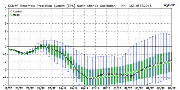
MARCH: With the Arctic Oscillation and North Atlantic Oscillation going negative, that sure opens the door for some sharp cold snaps next month, and maybe a few rounds of strong/severe storms. Winter is not over. See the Weather Xtreme video for maps, graphics, and more details.
BEACH FORECAST: Click here to see the AlabamaWx Beach Forecast Center page.
WEATHER BRAINS: Don’t forget you can listen to our weekly 90 minute netcast anytime on the web, or on iTunes. This is the show all about weather featuring many familiar voices, including our meteorologists here at ABC 33/40.
CONNECT: You can find me on all of the major social networks…
Facebook
Twitter
Google Plus
Instagram
Pinterest
Snapchat: spannwx
I had a great time today visiting with the 3rd graders at Walter Kennedy Elementary in Pell City… be looking for them on the Pepsi KIDCAM today at 5:00 on ABC 33/40 News! The next Weather Xtreme video will be posted here by 7:00 a.m. tomorrow…
Category: Alabama's Weather, ALL POSTS, Weather Xtreme Videos
About the Author (Author Profile)
James Spann is one of the most recognized and trusted television meteorologists in the industry. He holds the AMS CCM designation and television seals from the AMS and NWA. He is a past winner of the Broadcast Meteorologist of the Year from both professional organizations.Subscribe
If you enjoyed this article, subscribe to receive more just like it.


