Strong Storms to Reach NW Alabama by 10-11 p.m., Tuscaloosa / Birmingham by 3-4 a.m.
We continue to monitor a severe weather threat for the Mid-South into the Ohio Valley and southward into Arklatex,
The threat extends into Alabama for later tonight.
Here is the situation at 6:45…
RADAR CHECK
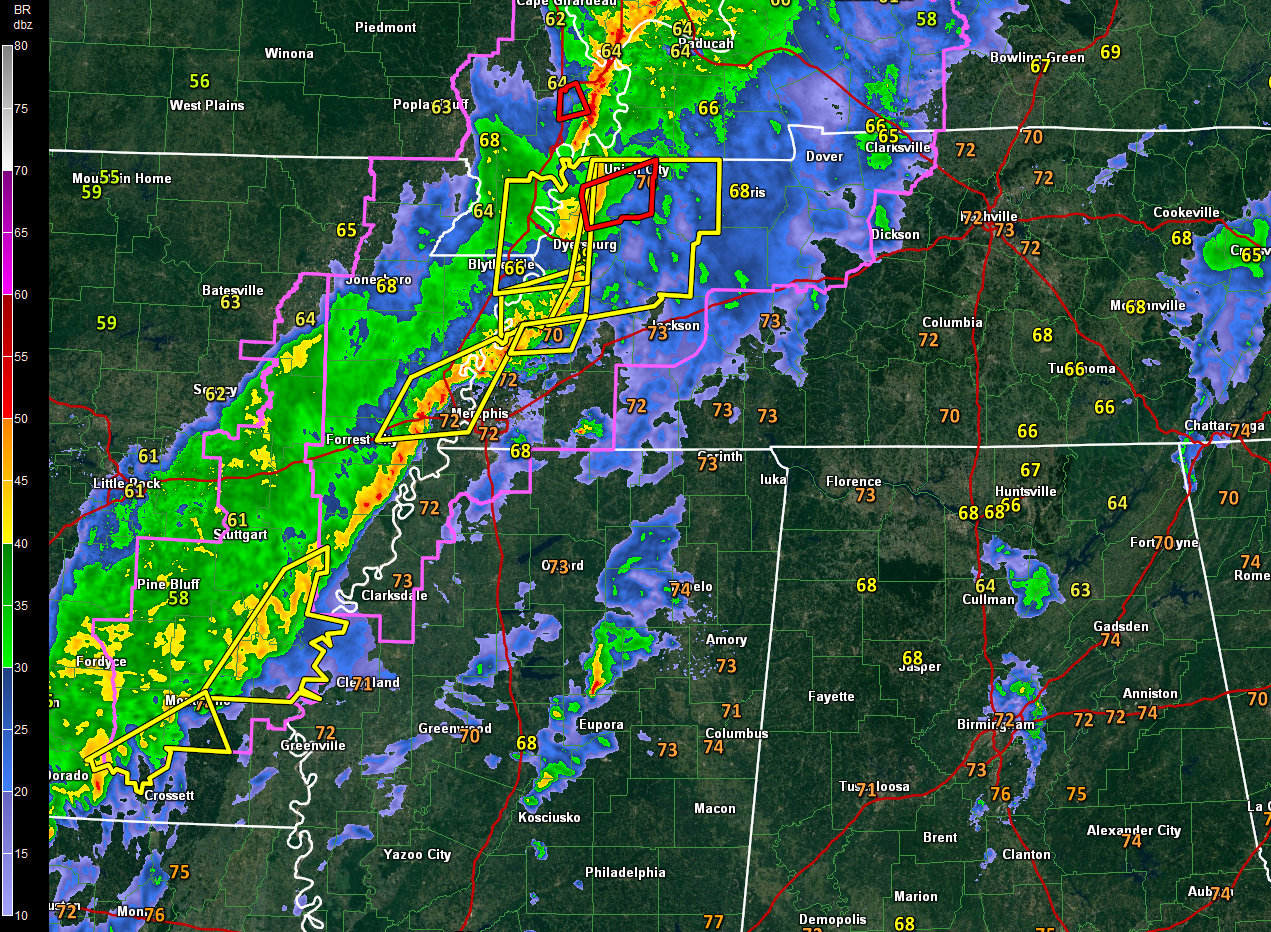
A few showers continue to move across North and Central Alabama early this evening. One complex is moving through eastern portions of the Birmingham Metro area. Other showers extend across Blount, Cullman and Morgan Counties. Everything is moving north-northeast. No lightning yet in any of this activity, although some brief heavy rain is occurring in spots.
Back in Mississippi, a few showers are east of I-55. No lightning in those cells either.
Further back, a line of storms extends from Northeast Texas, through the Shreveport area to the west of Memphis and then to the Missouri Bootheel.
A tornado watch extends from southeastern Arkansas into Northwest Mississippi and western Tennessee and then into southeastern Missouri and western Kentucky. Even a small portion of southern Illinois is in on the watch. A large and extremely dangerous tornado was on the ground in northwestern Tennessee near Ashport around 615 p.m. Other radar confirmed tornadoes have been reported in southeastern Missouri.
There is a tornado warning currently for the Union City area of NW Tennessee as well as for two counties in southeastern Missouri.
There are severe thunderstorm warnings across much of western Tennessee back into southeastern Arkansas.
But there are signs that the tornado watch will not be extended further east. Here is the thinking:
…Instability over eastern Mississippi and Alabama is waning slowly and convective inhibition is increasing. This inhibition, in the form of warmer mid-level temperatures, will make it harder for storms to become really strong, especially as we go through the evening.
…At 5,000 feet or 850 millibars, the strong low-level jet has become more southwesterly in direction, reducing the low-level wind shear.
…The surface low (1002 millibars) is over southeastern Missouri. Surface winds are backed, are more southeasterly over western Kentucky and western Tennessee. But over Mississippi and Alabama, the winds are more southerly and southwesterly. This will again, limit the low-level shear.
There still will be tornado reports over western Tennessee and western Kentucky over next 2 hours or so. And wind shear will be sufficient for some damaging winds into the overnight hours across northern Mississippi, western Tennessee and northwestern Alabama.
The line of storms should reach Northwest Alabama by 10-11 p.m., Hamilton by midnight, Jasper by 2 a.m., Tuscaloosa/Birmingham/Gadsden by 3-4 a.m. and Clanton and Anniston by 5 a.m.
It will reach the I-85 corridor by 8-9 a.m.
The storms will be weakening slowly as they push across North and Central Alabama. Damaging winds will be possible northwest of I-59.
The frontal system will stall near I-85 tomorrow morning. Another couple of rounds of showers and storms will overspread Central Alabama during the afternoon and overnight hours tomorrow, finally pushing out of the area Monday morning. Severe weather is possible tomorrow in places like Gadsden, Birmingham, Anniston, Chilton, Montgomery, Auburn, Greenville and Mobile.
Category: Alabama's Weather, ALL POSTS
About the Author (Author Profile)
Bill Murray is the President of The Weather Factory. He is the site's official weather historian and a weekend forecaster. He also anchors the site's severe weather coverage. Bill Murray is the proud holder of National Weather Association Digital Seal #0001 @wxhistorianSubscribe
If you enjoyed this article, subscribe to receive more just like it.


