A Few Showers At Midday, Strong Storms Possible In NW Alabama Later Today
Weather Check At 1:00 PM
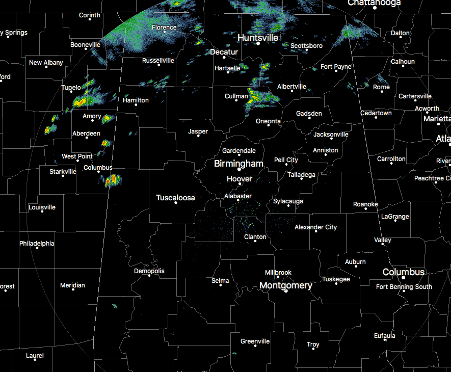
Conditions for most of North and Central Alabama are dry at this point, but there are several scattered showers out there over the northern half of the area. None of these showers are especially heavy, but more rain is expected to move through this afternoon and evening. Temperatures are currently in the lower 60s to the mid-70s throughout Central Alabama, with Birmingham sitting at 70 degrees.
Weather For The Rest Of Your Wednesday
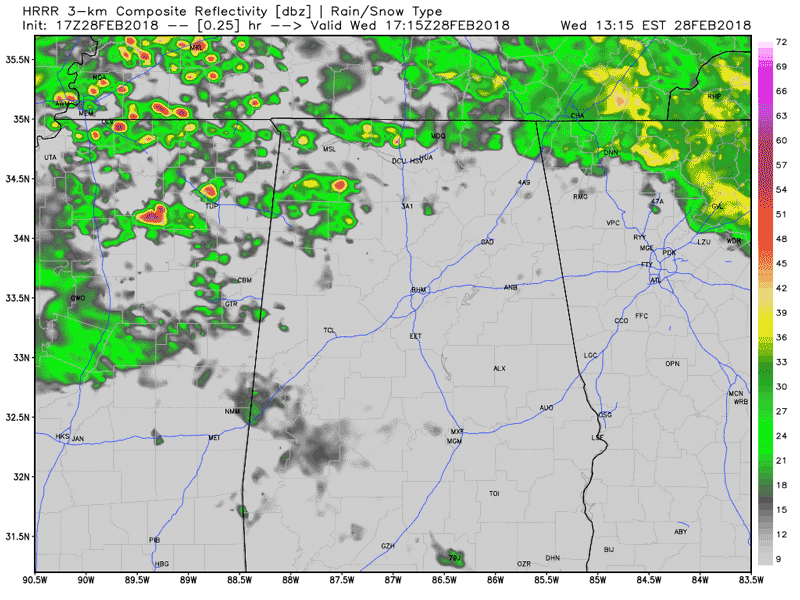
HRRR Simulated Radar solution valid through 6AM Thursday.
We’ll continue to have periods of showers and a few thunderstorm move through the northern half of the area and into North Alabama, while the southern half of the area will have a much smaller chance of a shower or two. Some of the storms passing through the western parts of North Alabama could be strong to severe this afternoon and evening, with strong winds being the main threat. At this point, the SPC does not have a defined risk for the area, but we’ll keep you posted on that. Another 1 to 3 inches of rainfall can be expected in North Alabama as well, and a Flood Watch is in effect. Highs in Central Alabama will top out in the upper 60s to near 80 degrees throughout the area, with lows in the 60s.
More Rain And Storms For Thursday
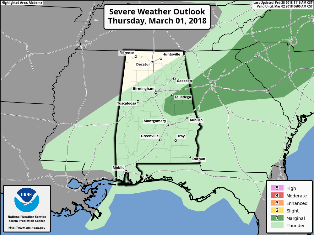
We’ll continue to have multiple waves of showers and thunderstorms move through Central Alabama for much of the day. There may be a few strong to marginally severe storms that develop out ahead and along the cold front over the west-central parts of the area, with the main threat being from damaging wind gust of 60 MPH. The tornado threat is very low but not zero, so we’ll have to watch for any brief spin-ups. Winds will be gusty at times as well due to the tightening pressure gradient. Winds will be averaging 15-25 MPH with gust up to 35 MPH possible. Afternoon highs will be in the mid-60s to the lower 80s from north to south. Much of the rain activity will be out of the area by the time we reach the newscast at 10PM, but a few lingering showers may be possible for a couple of more hours, especially over the extreme southern parts of the area. Lows will be in the upper 30s to the upper 40s.
Flood Watch In Effect For North Alabama
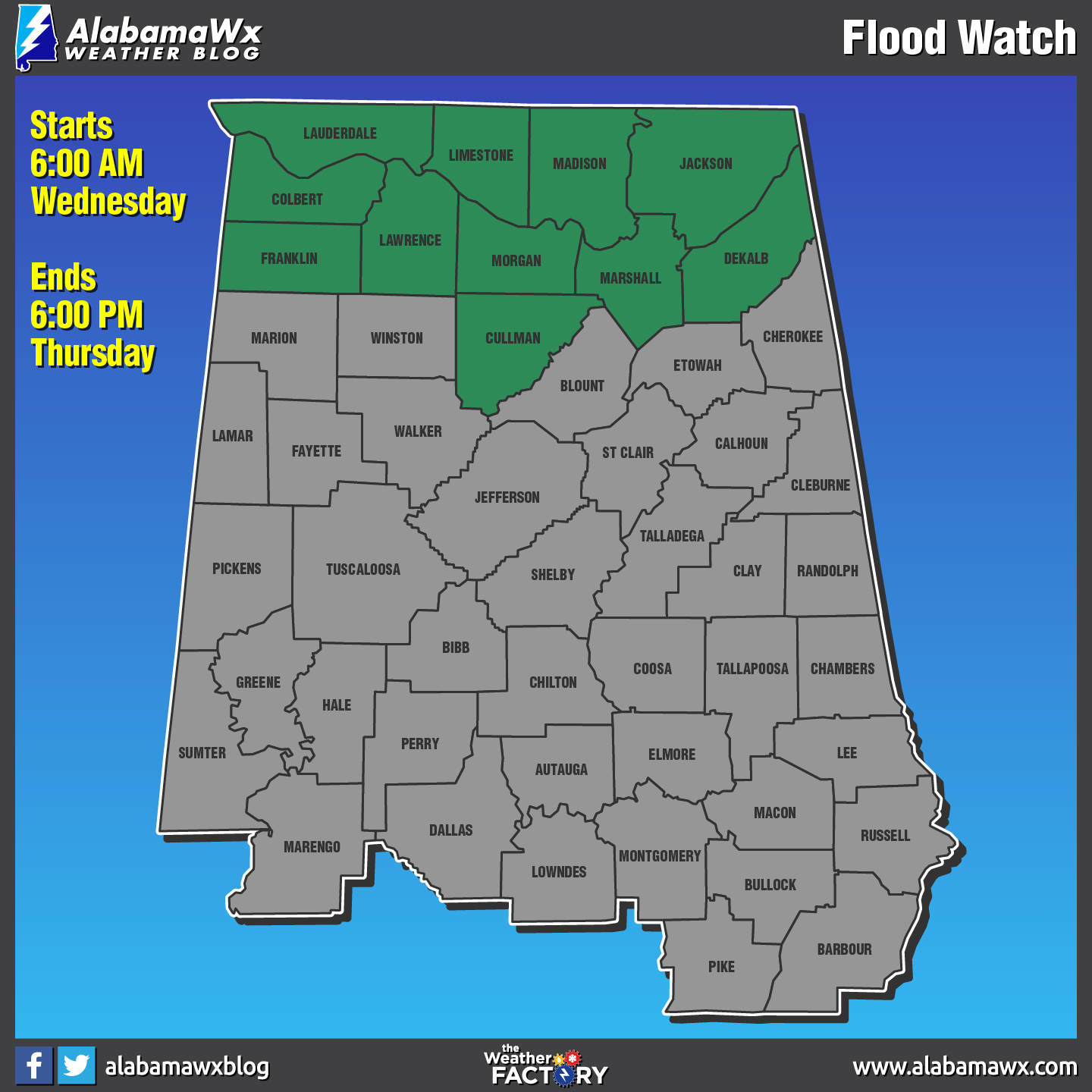
A Flood Watch remains in effect through Thursday afternoon for the following counties in North Alabama:
Colbert, Cullman, Dekalb, Franklin, Jackson, Lauderdale, Lawrence, Limestone, Madison, Marshall, and Morgan. 2 to 4 inches of rainfall is expected, with locally higher amounts up to 5 inches, are possible through Thursday afternoon. With area rivers and streams already running high combined with the saturated soils, it will not take much rain for areal and river flooding of low lying areas and some roadways to occur. Be smart… DO NOT DRIVE THROUGH WATER THAT IS COVERING THE ROAD.
Beach Forecast Center
Is it warm or cold at the beach today? Will it rain in two days? Get the latest forecast for the beaches from Fort Morgan to Panama City on our Beach Forecast Center page. There, you can select the forecast of the region that you are interested in.
WeatherBrains
This week, the panel entertained the Director of the GOES-R and JPSS satellite programs, Greg Mandt. Don’t forget you can listen to our weekly 90 minute netcast anytime on the web at WeatherBrains.com or on iTunes. This is the show all about weather featuring many familiar voices, including the meteorologists at ABC 33/40.
E-Forecast
Get the AlabamaWx Weather Blog’s Seven-Day Forecast delivered directly to your inbox by email twice daily. It is the most detailed weather forecast available in Central Alabama. Subscribe here… It’s free!
Advertise With Us
Don’t miss out! We can customize a creative, flexible and affordable package that will suit your organization’s needs. Contact Bill Murray at (205) 687-0782.
On This Day In Weather History
1987 – A powerful storm produced severe thunderstorms in Louisiana and Mississippi early in the day. About mid morning a monstrous tornado touched down near Moselle MS and grew to a width of two miles as it passed near Laurel MS. The tornado traveled a distance of 40 miles killing six persons, injuring 350 others, and causing 28.5 million dollars damage. The tornado swept homes right off their foundations, and tossed eighteen wheel trucks about like toys. Strong straight line winds associated with the powerful storm system gusted to 70 mph at Jonesboro AR and Carbondale IL.
Category: Alabama's Weather, ALL POSTS
About the Author (Author Profile)
Scott Martin is an operational meteorologist, professional graphic artist, musician, husband, and father. Not only is Scott a member of the National Weather Association, but he is also the Central Alabama Chapter of the NWA president. Scott is also the co-founder of Racecast Weather, which provides forecasts for many racing series across the USA. He also supplies forecasts for the BassMaster Elite Series events including the BassMaster Classic.Subscribe
If you enjoyed this article, subscribe to receive more just like it.


