Dry Weekend; Chilly Nights
SEVERE CLEAR: A cool, dry airmass covers Alabama this morning with temperatures mostly in the 40s at daybreak. Look for sunshine in full supply today with a high in the low 60s along with a cool north breeze. Tonight will be clear but rather chilly; we will see a low in the 32-35 degree range early tomorrow morning with scattered frost; colder pockets could visit the upper 20s.
Sunny, cool weather continues tomorrow and Sunday with highs in the 60s. Sunday morning will be cold again with a low in the 30-35 degree range for most places.
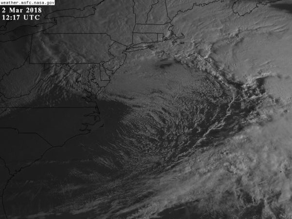
MAJOR NOR’EASTER: A rapidly deepening surface low is off the upper Atlantic coast of the U.S., producing very high winds from Maine down to Washington and Baltimore; it will bring coastal flooding, heavy rain, and some heavy snow to parts of the Northeast U.S. today. Air travelers beware… expect major disruptions and many cancelled flights.
We note a wind gust to 102 mph was recorded this morning atop Grandfather Mountain, NC (elevation 5,945′).
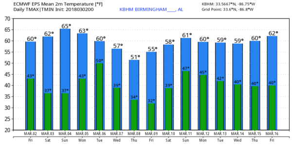
NEXT WEEK: Clouds increase Monday, and we will have a band of showers and storms in here late Monday afternoon and Monday night ahead of a cold front. Rain amounts of 1/2 to 1 inch look likely, and for now organized severe storms are not expected. The rain will end early Tuesday morning, and the latter half of the week looks pretty chilly as an upper trough sets up over the eastern U.S. We will have a hard time getting out of the 40s Wednesday and Thursday, and freezing temperatures seem likely both Thursday and Friday morning. See the Weather Xtreme video for maps, graphics, and more details.
ON THIS DATE IN 2012: A multiple-vortex EF-2 tornado crossed Lake Martin near the beginning of its path before passing near Jackson’s Gap, Eagle Creek, and Trammel Crossroads. Several homes sustained significant damage, and multiple mobile homes were completely destroyed. One mobile home frame was wrapped completely around a tree trunk. Thousands of trees were snapped and uprooted along the path… one was killed and two other people were injured.
The same day an EF-3 tornado moved through parts of Limestone and Madison Counties… it first moved through multiple subdivisions near Athens, with roofs torn off homes, windows and garage doors blown out, exterior walls damaged, and garages collapsed. The tornado then caused major roof and exterior wall damage to homes in and around Harvest. Homes at the north edge of Meridianville had their roofs torn off, a metal shed was severely damaged, a concrete power pole was snapped, and buildings at Meridianville Middle School sustained roof damage. The most intense damage occurred near Hazel Green, where several homes had roofs torn off and walls collapsed, and three were reduced to rubble.
BEACH FORECAST: Click here to see the AlabamaWx Beach Forecast Center page.
WEATHER BRAINS: Don’t forget you can listen to our weekly 90 minute netcast anytime on the web, or on iTunes. This is the show all about weather featuring many familiar voices, including our meteorologists here at ABC 33/40.
WEATHER BRAINS: Don’t forget you can listen to our weekly 90 minute netcast anytime on the web, or on iTunes. This is the show all about weather featuring many familiar voices, including our meteorologists here at ABC 33/40.
CONNECT: You can find me on all of the major social networks…
Facebook
Twitter
Google Plus
Instagram
Pinterest
Snapchat: spannwx
I have weather programs today at Miles Jewish Day School in Birmingham, and Montevallo Elementary School… look for the next Weather Xtreme video here by 4:00 this afternoon. Enjoy the day!
Category: Alabama's Weather, ALL POSTS, Weather Xtreme Videos
About the Author (Author Profile)
James Spann is one of the most recognized and trusted television meteorologists in the industry. He holds the AMS CCM designation and television seals from the AMS and NWA. He is a past winner of the Broadcast Meteorologist of the Year from both professional organizations.Subscribe
If you enjoyed this article, subscribe to receive more just like it.


