Decent and Warm St. Patty’s Day Afternoon
It was a soggy start to the day but through the day we have seen improving weather and for the rest of today, we should see decent weather.
Though a few light showers will remain possible, we should see a mix of sun and clouds with temperatures well into the 70s this afternoon.

A weak cold front will push into the area this evening, triggering a few showers, and maybe a little thunder, but severe weather shouldn’t be a threat and for the most part I think we should remain dry across North/Central Alabama tonight, with temperatures in the 50s and areas of patchy fog.
STORMY TIMES AHEAD: The weak front settles into Central Alabama and stalls overnight. For our Sunday, the day will be mostly cloudy, but a little sunshine will push temperatures into the lower 70s by tomorrow afternoon. Another disturbance will slide eastward towards Alabama late Sunday and into early Monday morning, triggering a round of extensive rain and some thunderstorms.
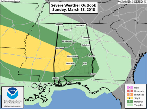
We note the SPC has much of Alabama highlighted in a “marginal risk” (level 1 out of 5) tomorrow with a “slight risk” extending into southwestern portions of the state, and this will be due to a warm front lifting back to the north we would allow for an enhancement of dynamics as well as instability building north. Scattered strong and severe storms are possible Sunday afternoon and night. Damaging wind gusts, hail, and tornadoes will be possible. Rainfall amounts could be pretty decent with this system, totaling over an inch. This will be round one of possible severe weather with round two arriving Monday.
Category: Alabama's Weather, ALL POSTS
About the Author (Author Profile)
Macon, Georgia Television Chief Meteorologist, Birmingham native, and long time Contributor on AlabamaWX. Stormchaser. I did not choose Weather, it chose Me. College Football Fanatic. @Ryan_StinnetSubscribe
If you enjoyed this article, subscribe to receive more just like it.


