Stormy ! !
The weather will be stormy for the next couple of days as the Southeast US experiences the threat of severe weather. Sunday is starting out with some cloudiness with a weak cold front located just north of the Birmingham area as evidenced by dew points on the surface map. Temperatures are in the middle 50s at this writing around 6 am. Aloft we have a trough digging into the West Coast that will quickly move out into the Central Plains on Monday. This feature will send out a weak disturbance that will bring the first round of severe weather to southern sections of the Southeast US today. This is NOT the main event. Conditions today and this evening appear favorable for a round of severe thunderstorms with damaging wind the most likely occurrence. This threat appears to be south and southwest of the Birmingham area generally along and south of the US 80 corridor from Demopolis to Montgomery to Eufaula.

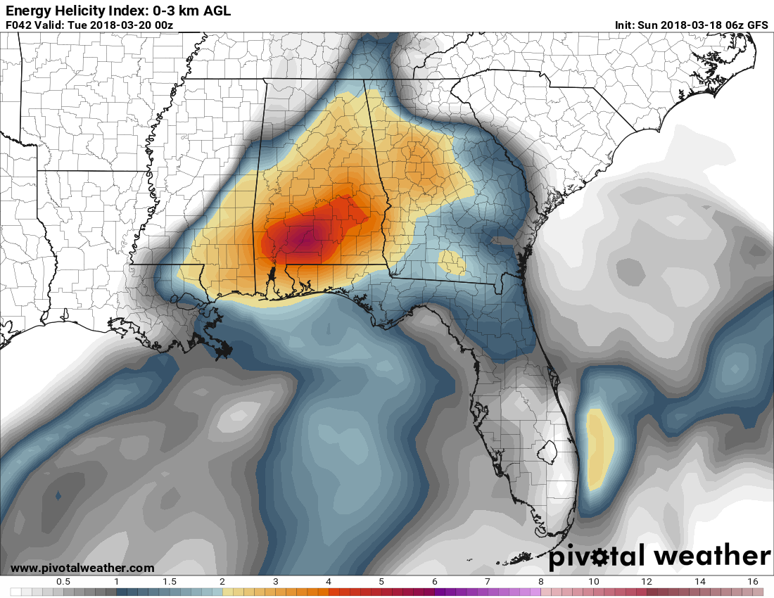
As the upper trough comes out into the Central US over southern Missouri, the real action will come Monday afternoon. Energy Helicity Index or EHI looks at the instability (CAPE) and the Storm Relative Helicity (SRH). EHI values greater than 1-2 have been associated with significant severe weather associated with supercells. EHI values climb to values above 3 across the northern two-thirds of Alabama Monday afternoon around 4 pm. The storms later today are expected to lift north into the Tennessee Valley and north Georgia. We should be in the warm sector from late morning into early afternoon making for a pretty nice day. But that is when the influence of the upper trough will begin to have an impact along with destabilization of the atmosphere with strong heating. All modes of severe weather will be possible including tornadoes, large hail, and damaging wind.
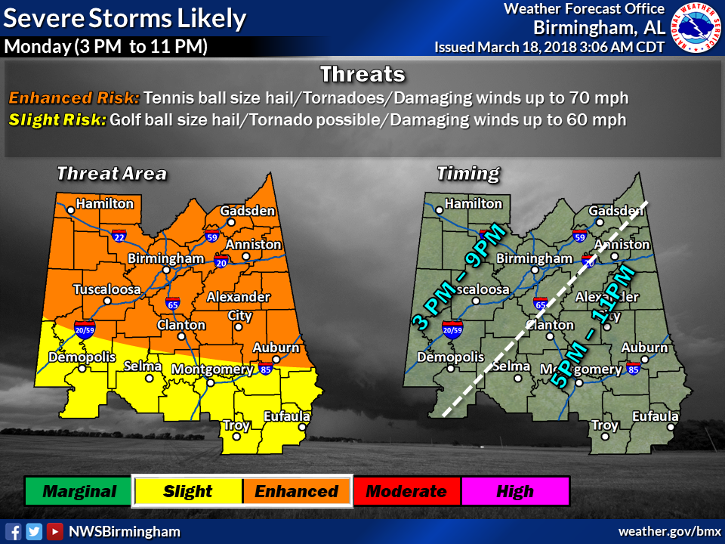
This corresponds pretty well with the SPC severe weather outlook as well as the outlook coming out of NWS Birmingham for Sunday afternoon. Timing shown in the NWS Birmingham graphic below gives you a good idea of when you can expect to see severe weather in Central Alabama.
The upper closed low opens up on Tuesday as it moves by bringing an end to the severe weather around midnight. A trailing upper trough over the western Great Lakes area digs into the Southeast US right behind the first trough reinforcing a deep trough over the East Coast. This will bring a northerly flow at the surface along with a good northwesterly flow aloft which will push morning lows back into the 30s for Wednesday and Thursday mornings.
But don’t dismay! In true Southeast US fashion we come under an upper ridge by Friday promoting a return to warm weather with highs by Friday climbing into the 70s. Another short wave trough in the Central US will develop a surface low over northeast Kansas that will move rapidly eastward to Virginia on Saturday trailing a cold front into the Southeast US and bringing the threat of showers. Precipitable water values are fairly low, so I only expect to see scattered showers with this system.
The GFS is projecting a nice upper ridge in place by midday on Sunday which could produce another very warm day with highs coming close to the 80-degree mark.
Looking into voodoo country, warm with sticks around with an upper ridge through the 27th of March. Another strong trough/short wave is forecast to come out of the Southwest US around the 30th which could produce another round of severe weather. That short wave moves to the Carolinas by April 1st bringing only a slight cool down to the Southeast US with a northwest flow that only originates in the Central US.
Beach Forecast: Click here to see the AlabamaWx Beach Forecast Center page.
WeatherBrains: Don’t forget you can listen to our weekly 90 minute netcast anytime on the web, or on iTunes. This is the show all about weather featuring many familiar voices, including our meteorologists here at ABC 33/40.
Special thanks to Bill Murray for handling the blog video yesterday. Due to travel and illness, I ended up working all of the weather shifts on Friday starting with the early news at 4:30 am and going through the day to the 10 pm news Friday night. If I had tried to produce a video on Saturday morning, it would have been a disaster!! Please be aware of the severe weather potential over the next two days and keep weather safety at the forefront of your thinking. I’ll be filling in for Charles Daniel this evening on ABC 3340 News at 5 and 10 pm, so be sure to tune in for the latest update on the severe weather potential.
-Brian-
.
Category: Alabama's Weather, ALL POSTS, Weather Xtreme Videos
About the Author (Author Profile)
Brian Peters is one of the television meteorologists at ABC3340 in Birmingham and a retired NWS Warning Coordination Meteorologist. He handles the weekend Weather Xtreme Videos and forecast discussion and is the Webmaster for the popular WeatherBrains podcast.Subscribe
If you enjoyed this article, subscribe to receive more just like it.


