Line Of Showers Entering The Central Parts Of The Area; Strong/Severe Storms Still Possible

The good news is that the severe threat currently still remains very low across Central Alabama, but as the atmosphere starts to destabilize with the approaching dynamics of the system and the heating of the day, there is still the potential for a few severe storms. Main threats continue to be from damaging thunderstorm wind gusts of 60MPH and a few tornadoes.
As of 11:30 AM, the line of showers and embedded heavier rain is approaching the central parts of the area. Demopolis, Tuscaloosa, and Parrish will be the next larger locations that will see the line move into their areas. Winds will be a little gusty along and out ahead of the line, but there is no lightning showing up at this time.
NWS Birmingham will be launching a special sounding at noon before the line moves into the area to see what the atmospheric conditions hold at that point.

The Storm Prediction Center continues to have much of Central Alabama in a Slight Risk for severe storms throughout the day, while much of the rest of the state is defined in a Marginal Risk. I believe once the line passes your location, the threat for any severe storms will be over. The risk areas have been reduced in size and the western parts of the state have been removed from any risks.
Stronger to a few severe storms still look possible over the central and eastern parts of the area. The northeastern parts of the area have received a decent amount of sunshine throughout the morning, so we may have to watch for stronger storm development up in that area. Surface-based instability is continuing to build over the eastern 2/3rds of Central Alabama, and will be approaching 1200 J/kg soon. We’ll also have decent shear values in the lower levels, and that will allow for the possibility of a few supercells capable of producing damaging wind gusts and a few tornadoes.
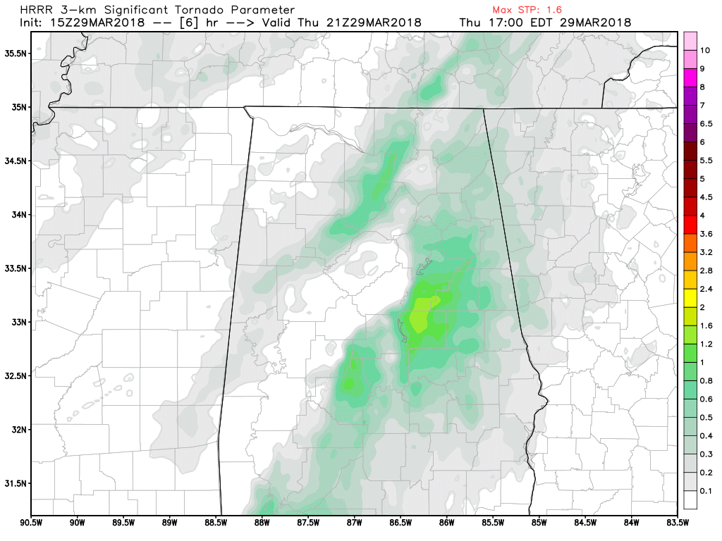
HRRR Significant Tornado Parameter values at 4:00 PM today.
Significant tornado parameter values are maxing out at 1.6 over the eastern parts of the area this afternoon. This is no where near the values that we experienced back on March 19th, but this does show that there is a possibility of a brief tornado or two.
Timing still looks about the same as the earlier update. From now until 5:00 PM for much of the central parts of the area (including the cities of Birmingham, Tuscaloosa, Jasper, Demopolis, Selma, and Clanton), and from 3:00 PM until 7:00 PM for the eastern parts of the area (including the cities of Gadsden, Anniston, Alexander City, Auburn, Montgomery, Troy, and Eufaula).
Rain will be out of here just after midnight and skies will begin to clear out some during the overnight hours. Lows will dip down into the upper 40s to the mid-50s throughout the area by sunrise Friday morning.
Continue to check the blog throughout the afternoon. We’ll keep you posted any forecast changes and we’ll have active warnings listed on our site when/if issued.
Category: Alabama's Weather, ALL POSTS
About the Author (Author Profile)
Scott Martin is an operational meteorologist, professional graphic artist, musician, husband, and father. Not only is Scott a member of the National Weather Association, but he is also the Central Alabama Chapter of the NWA president. Scott is also the co-founder of Racecast Weather, which provides forecasts for many racing series across the USA. He also supplies forecasts for the BassMaster Elite Series events including the BassMaster Classic.Subscribe
If you enjoyed this article, subscribe to receive more just like it.


