Showers & Storms Moving In; Forecast For Possible Strong To Severe Storms Still On Track
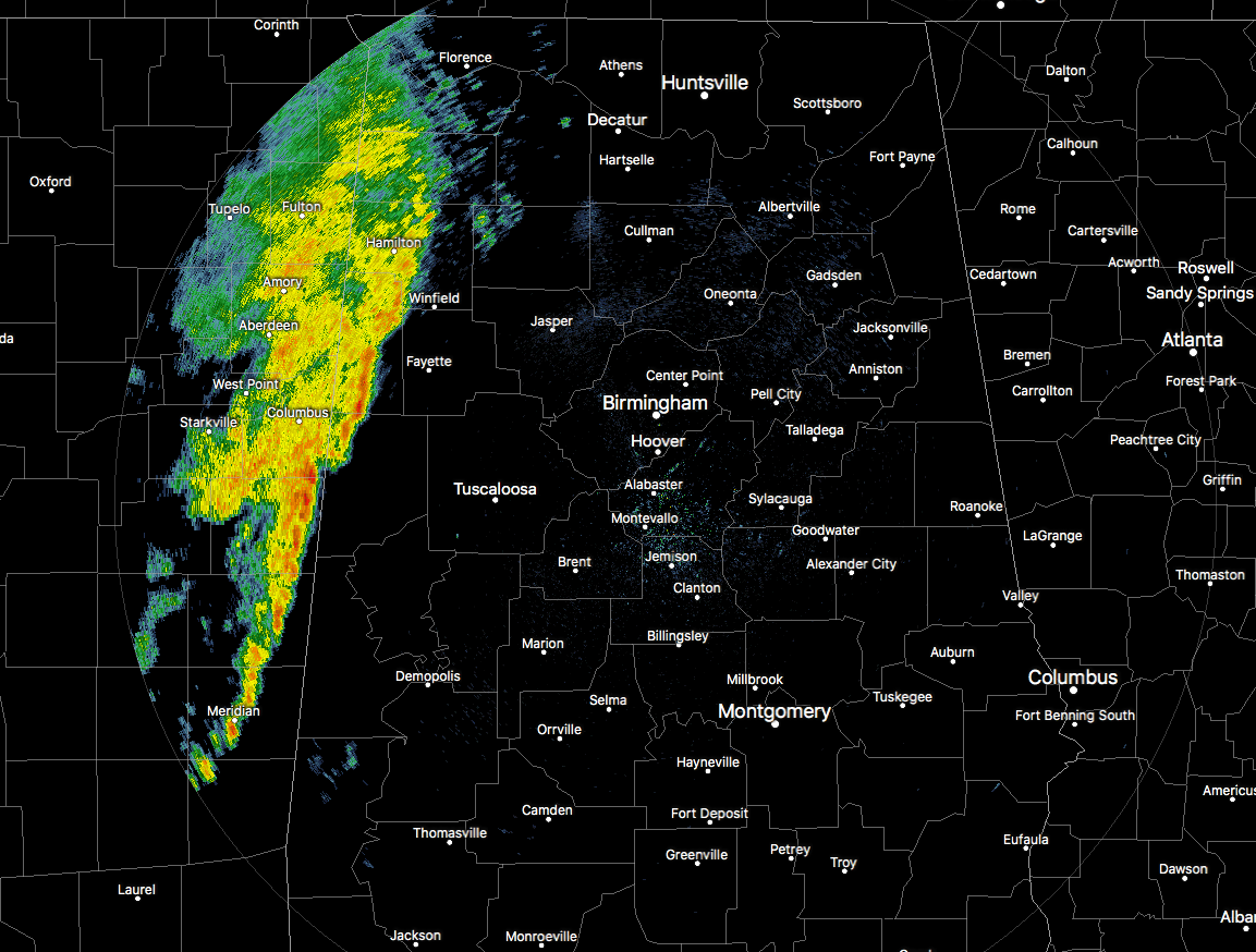
Showers and a few embedded rumbles of thunder have now entered the northwestern parts of Central Alabama, mainly affecting the western parts of Marion, Lamar, and Pickens counties. The good news is that there are no active severe weather watches and warnings in effect for anyone in Mississippi or Alabama at this point, and let’s hope it stays that way. This activity will continue to slowly push eastward throughout the day. More active weather is expected to fire up during the afternoon and early evening hours. Details are listed below.
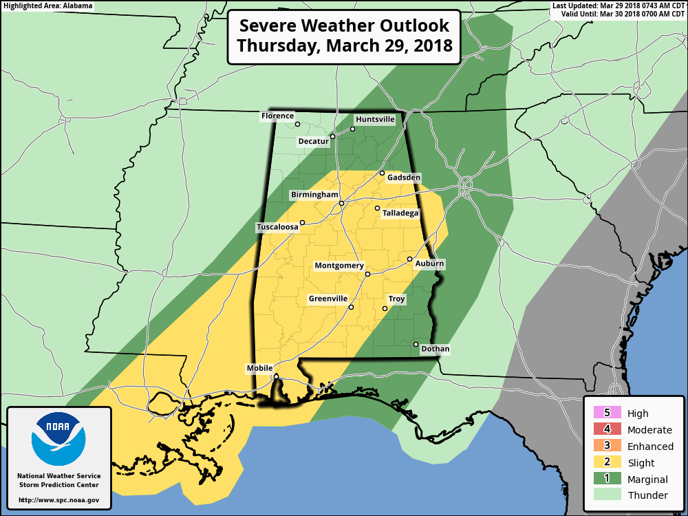
The Storm Prediction Center continues to have much of Central Alabama in a Slight Risk for severe storms throughout the day, while much of the rest of the state is defined in a Marginal Risk. Main threats will be from damaging straight line thunderstorm wind gusts up to 60 MPH and a few tornadoes in the Slight Risk areas. Those same threats are less likely for the Marginal Risk areas but cannot be completely ruled out.
At this point, the forecast is still in line with earlier thinking, with the possibility of strong to severe storms not occurring until the afternoon and evening hours. That will be when the atmosphere will have a chance to better destabilize with the heating of the day, along with when the better dynamics with this system arrives. The low-level jet is expected to reach 40-50 knots and surface-based instability (CAPE) values up to 1200 J/kg. Those values, along with 30-35 knot low-level shear, will allow for the possibility of isolated damaging thunderstorm wind gusts up to 60 MPH and the threat of a tornado or two.
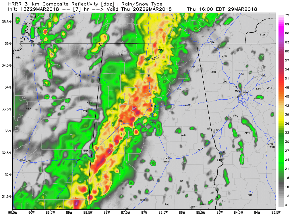
HRRR Simulated Radar at 3:00 PM today.
The main window for strong to severe storms throughout Central Alabama will be from noon until 7:00 PM tonight. Storms will be the most active in the west-central and central parts of the area from noon until 5:00 PM (mainly west of a line from Sardis City in Etowah County to Clanton to Benton in Lowndes County), including the cities of Birmingham, Tuscaloosa, Demopolis, and Selma. Those active storms will make it into the eastern parts of the area by 3:00 PM and will persist until around 7:00 PM for locations east of a line from Sardis City to Clanton to Benton (including the cities of Gadsden, Anniston, Alexander City, Auburn, Montgomery, Troy, and Eufaula).
Even though this will be nothing like the event on March 19th, we still want you to have your safety kit and plan ready to go just in case you are placed in a warning. Have your smartphones charged and fresh batteries in your flashlights and NOAA Weather Radio. We’ll keep you posted on the blog throughout the day.
Category: Alabama's Weather, ALL POSTS
About the Author (Author Profile)
Scott Martin is an operational meteorologist, professional graphic artist, musician, husband, and father. Not only is Scott a member of the National Weather Association, but he is also the Central Alabama Chapter of the NWA president. Scott is also the co-founder of Racecast Weather, which provides forecasts for many racing series across the USA. He also supplies forecasts for the BassMaster Elite Series events including the BassMaster Classic.Subscribe
If you enjoyed this article, subscribe to receive more just like it.


