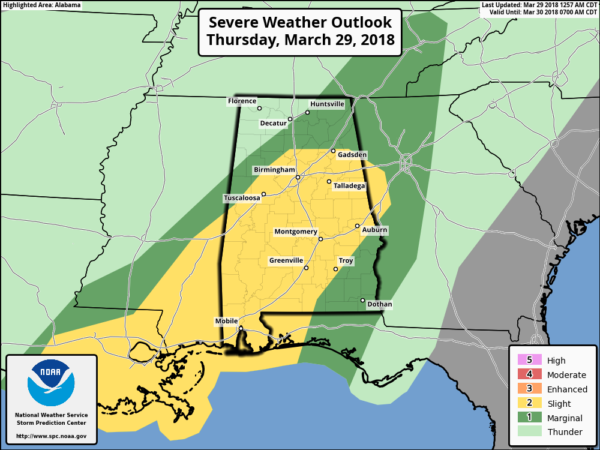
A Few Strong/Severe Storms Possible Later Today
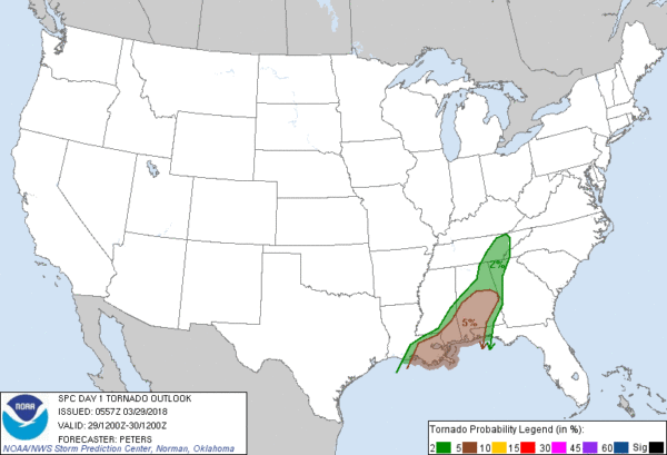
ACTIVE WEATHER DAY: An approaching upper trough/surface front will bring showers and thunderstorms to Alabama today. SPC maintains some risk of severe storms over a decent part of the state…
TIMING: Things are fairly quiet at daybreak with just a few showers over far West and Northwest Alabama; the main threat of stronger storms will come this afternoon when the air will be more unstable, generally from 11:00 a.m. until 6:00 p.m.
THREATS: The core risk with the heavier storms will come from strong, gusty straight line winds and small hail. An isolated short lived tornado can’t be ruled out, especially over the southern half of the state, where instability values will be a little higher.
RAIN AMOUNTS: A flood watch is in effect for three counties in far Northwest Alabama… Lauderdale, Franklin, and Colbert. Rain amounts there could approach two inches, otherwise totals will be around 1 inch or less, and no flooding issues are expected.
The bottom line is that shear, instability, wind fields, and lapse rates just aren’t that impressive for severe storms today, but when it comes to thunderstorms, you have to expect the unexpected and we will keep a close watch on convection the forms. We stress this will be nothing like March 19, when we had 15 tornadoes and destructive hail across our state.
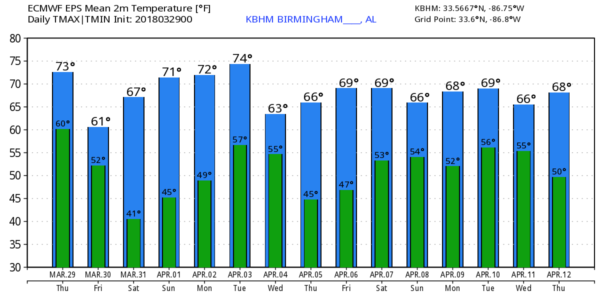
TOMORROW AND THE WEEKEND: Look for a clearing sky tomorrow with a high in the 60s; then we will enjoy a delight Easter weekend. Ample sunshine on Saturday with a high in the mid 70s; a partly to mostly sunny sky Sunday with a high holding in the mid 70s.
NEXT WEEK: The latest GFS hints that most of the state will stay dry and very mild Monday and Tuesday with highs in the 77-80 degree range; a cold front will then bring a good chance of rain and storms Tuesday night into early Wednesday, followed by cooler, drier air. But, model inconsistency is not good and the forecast confidence for next week is low at this point. See the Weather Xtreme video for maps, graphics, and more details.
BEACH FORECAST: Click here to see the AlabamaWx Beach Forecast Center page.
WEATHER BRAINS: Don’t forget you can listen to our weekly 90 minute netcast anytime on the web, or on iTunes. This is the show all about weather featuring many familiar voices, including our meteorologists here at ABC 33/40.
CONNECT: You can find me on all of the major social networks…
Facebook
Twitter
Google Plus
Instagram
Pinterest
Snapchat: spannwx
Look for the next Weather Xtreme video here by 4:00 this afternoon… enjoy the day!
Category: Alabama's Weather, ALL POSTS, Weather Xtreme Videos
About the Author (Author Profile)
James Spann is one of the most recognized and trusted television meteorologists in the industry. He holds the AMS CCM designation and television seals from the AMS and NWA. He is a past winner of the Broadcast Meteorologist of the Year from both professional organizations.Subscribe
If you enjoyed this article, subscribe to receive more just like it.


