Egg-Ceptional Weather for Easter Weekend
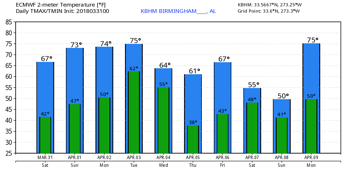
The satellite view of Alabama early this morning showed clear sky with only a few cirrus clouds streaming across the southeast corner. Temperatures were fairly chilly with readings in the upper 30s and lower 40s. Look for a sunny day today with highs climbing into the lower 70s – great weather for the first half of the Easter weekend.
The nearly zonal flow aloft remains with us for Easter Sunday promising another fine day with a few more clouds as a weak front dissipates to our north. We should see highs in the upper 70s.
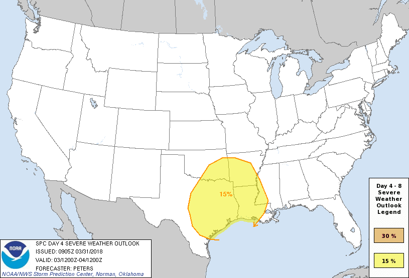
On Monday we see an upper trough taking shape in the Northwest US that will move quickly into the eastern Dakotas on Tuesday and eastern Great Lakes region by Wednesday. This will generate a surface low in eastern Wyoming Monday that moves to the vicinity of Chicago on Tuesday and northern Maine by Wednesday. This will bring a cold front into the Lower Mississippi River Valley at midday on Tuesday that will produce thunderstorms across the Southeast US from late Tuesday into Wednesday. While the primary dynamics remain fairly far north, CAPE values surge upward on Tuesday evening and early Wednesday morning into the 1200 to 1400 j/kg range with fairly good shear across the northern half of Alabama. EHI values are in the range of 1 to 2, so severe weather is a possibility. At least for now, the primary threat appears to be that of damaging wind. SPC has outlined a risk area for Day 4.
The upper trough moves into the Atlantic as the front sweeps out of the area in the latter half of Wednesday bringing an end to the precipitation. Wednesday will be a rather chilly day with temperatures during the day mainly in the 50s.
Thursday morning the surface high settles in across Alabama. With northwesterly flow aloft, it looks like we could see good radiational cooling for Thursday morning with lows in the middle and upper 30s. We potentially have a risk for seeing some frost on Thursday morning.
Friday should be dry with little change to the pattern, but a short wave trough moving across Texas on Friday and into Mississippi on Saturday promises to bring us a wet start to next weekend with a broad low pressure area along the Central Gulf Coast. This poses another potential scenario for a round of severe weather in the Day 7 and Day 8 time frame, but predictability this far out is not generally good plus there are model differences, so we’ll maintain a close watch on this situation in future runs. Friday should be a bit warmer with highs in the lower 70s while Saturday could be cooler with highs in the 60s. Temperatures next Saturday will depend on strength and position of the surface low.
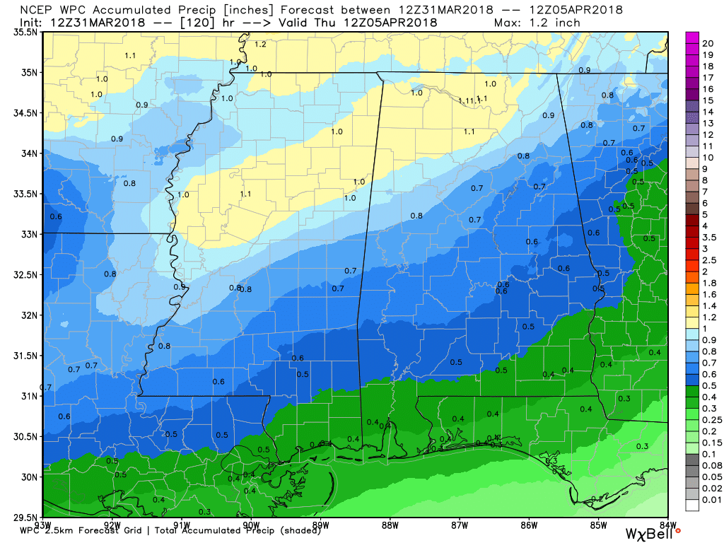
Rainfall during the next five days will once again present with a northwest to southeast gradient with around an inch in the northwest corner to around a half inch in the southeast corner.
Looking into voodoo country, the upper ridge becomes strong around the 9th of April signaling a fairly warm period. The GFS projects a strong trough coming into the Lower Mississippi River Valley on the 11th of April which definitely has a severe weather look to it. But the upper ridge returns strongly around the 15th of April.
Beach Forecast: Click here to see the AlabamaWx Beach Forecast Center page.
WeatherBrains: Don’t forget you can listen to our weekly 90 minute netcast anytime on the web, or on iTunes. This is the show all about weather featuring many familiar voices, including our meteorologists here at ABC 33/40.
I’ll be filling in for Charles Daniel this weekend, so you can catch the latest forecast with ABC 3340 News at 5 and 10:45 pm this evening. The late news will be a little later than usual as we broadcast the movie The Ten Commandments. Have a great day and Godspeed.
-Brian-
.
Category: Alabama's Weather, ALL POSTS, Weather Xtreme Videos
About the Author (Author Profile)
Brian Peters is one of the television meteorologists at ABC3340 in Birmingham and a retired NWS Warning Coordination Meteorologist. He handles the weekend Weather Xtreme Videos and forecast discussion and is the Webmaster for the popular WeatherBrains podcast.Subscribe
If you enjoyed this article, subscribe to receive more just like it.


